
Threatened Ecological Communities

By 2023, the implementation of priority actions is leading to an improvement in the condition of EPBC Act listed Threatened Ecological Communities.
Investment Priorities:
- Brigalow (Acacia harpophylla dominant and codominant).
- Broad leaf tea-tree (Melaleuca viridiflora) woodlands in high rainfall coastal north Queensland.
- Coolibah – Black Box Woodlands of the Darling Riverine Plains and the Brigalow Belt South Bioregions.
- Littoral Rainforest and Coastal Vine Thickets of Eastern Australia.
- Natural Grasslands of the Queensland Central Highlands and northern Fitzroy Basin.
- Poplar Box Grassy Woodland on Alluvial Plains.
- Semi-evergreen vine thickets of the Brigalow Belt (North and South) and Nandewar Bioregions.
- The community of native species dependent on natural discharge of groundwater from the Great Artesian Basin.
- Weeping Myall Woodlands.
Background Information:
An ecological community is a collection of native species (plants, animals and other organisms) that are found in a specific geographic location and that have evolved together over time. The species in the community interact with each other and with other factors in the environment, such as the soil and climate in such a way that the community is unique.
Ecological communities are often defined by their dominant vegetation type or structure and the location. Preservation of the community requires that the system as a whole is preserved, thereby maintaining the organisms and relationships that make the community unique.
An ecological community is considered threatened when the extent and condition of the community has been compromised to the extent that it is at risk of extinction. Threatened Ecological Communities are prescribed under the Environment Protection and Biodiversity Conservation Act 1999 and are classified as Critically Endangered, Endangered or Vulnerable.
There are 17 Threatened Ecological Communities in Queensland and 8 in the Burdekin Dry Tropics region, one of which is Critically Endangered, while the other 7 are Endangered. The table below summarises the name, status and occurrence of the eight Threatened Ecological Communities of the region.
| Abbreviated Name | Status | Occurrence in Area |
| Brigalow | Endangered | Known to occur |
| Broad-leaf tea-tree woodlands | Endangered | Likely to occur |
| Coolibah-Black Box Woodlands | Endangered | May occur |
| Littoral Rainforest & Coastal Vine Thickets | Critically Endangered | Likely to occur |
| Natural Grassland of Central Highlands & northern Fitzroy Basin | Endangered | Likely to occur |
| Poplar Box Grassy Woodland | Endangered | Likely to occur |
| Semi-evergreen vine thickets of the Brigalow Belt & Nandewar Bioregions | Endangered | Likely to occur |
| Great Artesian Basin community | Endangered | Likely to occur |
| Weeping Myall Woodlands | Endangered | Likely to occur |

Alignment with Sub-regional aspirations and regional goals
These threatened ecological communities lie within the following sub-regions and aligns with their sub-regional goals:
- Burdekin rangelands sub-region: Sustainable land use – Our community would like to protect our land, which is a source of cultural identity and an inspiration for current and potential new enterprises, including tourism. We will continue to support property management, which integrates actions to look after soils, water, vegetation, weeds and feral animals, with agricultural best practice and business sustainability. We will strive to achieve good soil biodiversity, which benefits pasture, captures moisture and carbon, and prevents erosion (Page 14).
- Townsville Coastal Plains and Offshore sub-region: Connected corridors and urban green space – Our region is managed for residential lifestyles which are integrated with, and sensitive to, the natural environment. Our community wants to improve this by creating more natural links between urban green spaces and within agricultural land, identifying biodiversity hot spots, enhancing habitat and riparian corridors, and protecting intact coastal foreshores. The integrity of our coastline is important to protect against storm surges, waves, wind and overland flows, which may require sand and vegetation restoration works (Page 16).
- Lower Burdekin and offshore sub-region: Recognised land stewardship and control of introduced pests – Our farmers are stewards of the land, who seek to achieve social, economic and environmental outcomes for their enterprises to create security for their families and the community. Our community will encourage them to increase their uptake of best management practices and explore opportunities for financial incentives to reward sustainable practices. We will encourage urban development without the loss of prime farm land, and promote the importance of urban, rural and peri-urban residents proactively working together to tackle pest and weed issues. We would like to foster strategic and compatible land use to realise its full potential, while maintaining soil health and reducing unnecessary financial inputs (page 18).
- Bowen catchments and offshore sub-region: Passionate people caring for our landscapes – Our community greatly values the wetlands, beaches, rivers, dunes and woodlands that make up our region. One of our greatest resources is a community that is passionate about caring for these landscapes. Our diverse marine and terrestrial habitats support a variety of industries. We are a small community, and to sustain these environments and industries into the future we need appropriate long-term career pathways and methods to retain NRM professionals with local knowledge. We believe technology can increase community awareness, and may encourage greater local actions to support sustainability (page 20).
- Belyando–Suttor sub-region: Landholder and industry capacity for strong bio-security – Working with government, we would like to be empowered to undertake effective bio-security practices that mitigate risks to and from local industries. We would like to see collaborative decision making lead to proactive funding and support that allows landholders to achieve outcomes, and industries to conserve important natural ecosystems (page 22).
This outcome aligns with the regional goal in the NRM Plan:
- The unique biodiversity of the Burdekin Dry Tropics region is protected and enhanced to increase the resilience of native species, ecosystems and ecological processes (page 67).
The right to protect Country and culture is fundamental to Traditional Owners as the custodians of Country based on a history of more than 60,000 years. Traditional Owners aspire to have greater management, involvement and empowerment over Country and their cultural knowledge and understanding of Country are embraced. The Traditional Owner aspirations for the region can be found in the Burdekin Dry Tropics NRM Plan (pages 25-26), Caring for Country Plan (2005) and the Indigenous Participation Plan. Access to Country to connect and manage cultural and natural resources continue to be priorities for Traditional Owners. A map of Traditional Owner group areas can be accessed here.
Links and further information:
More information on Threatened Ecological Communities – https://www.environment.gov.au/biodiversity/threatened/communities/about
 Brigalow – dominant and codominant
(Acacia harpophylla)
Status: Endangered – Environment Protection and Biodiversity Conservation Act 1999 (EPBC Act).
Conservation Advice: There an Approved Conservation Advice for this ecological community (2013).
Recovery Plan: There no adopted or made Recovery Plan for this ecological community.
Threat Abatement Plan: There is one Threat Abatement Plan for this ecological community (Cane toads).
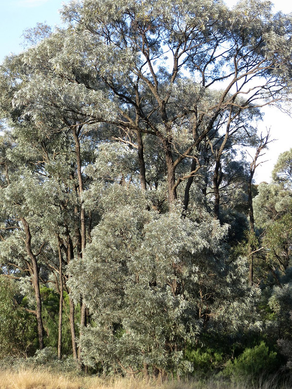
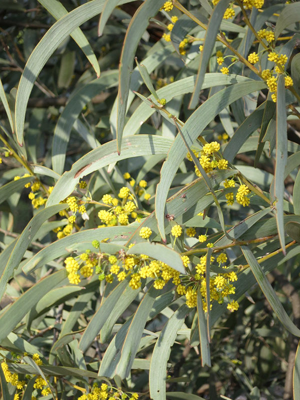
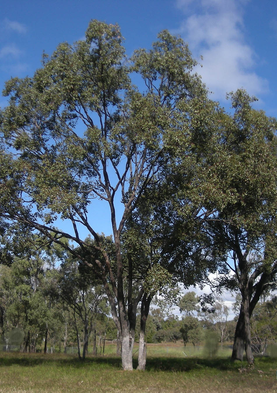
Acacia harpophylla is a native Australian species of acacia, with the common name of Brigalow. It grows to around 25m in height and is found on predominantly fertile, clay soils. It is characterised by a dark, hard bark, silvery-grey leaves and yellow flowers, that are similar to other wattle species. It is usually found with other native plant species such as casuarina and eucalypt species.
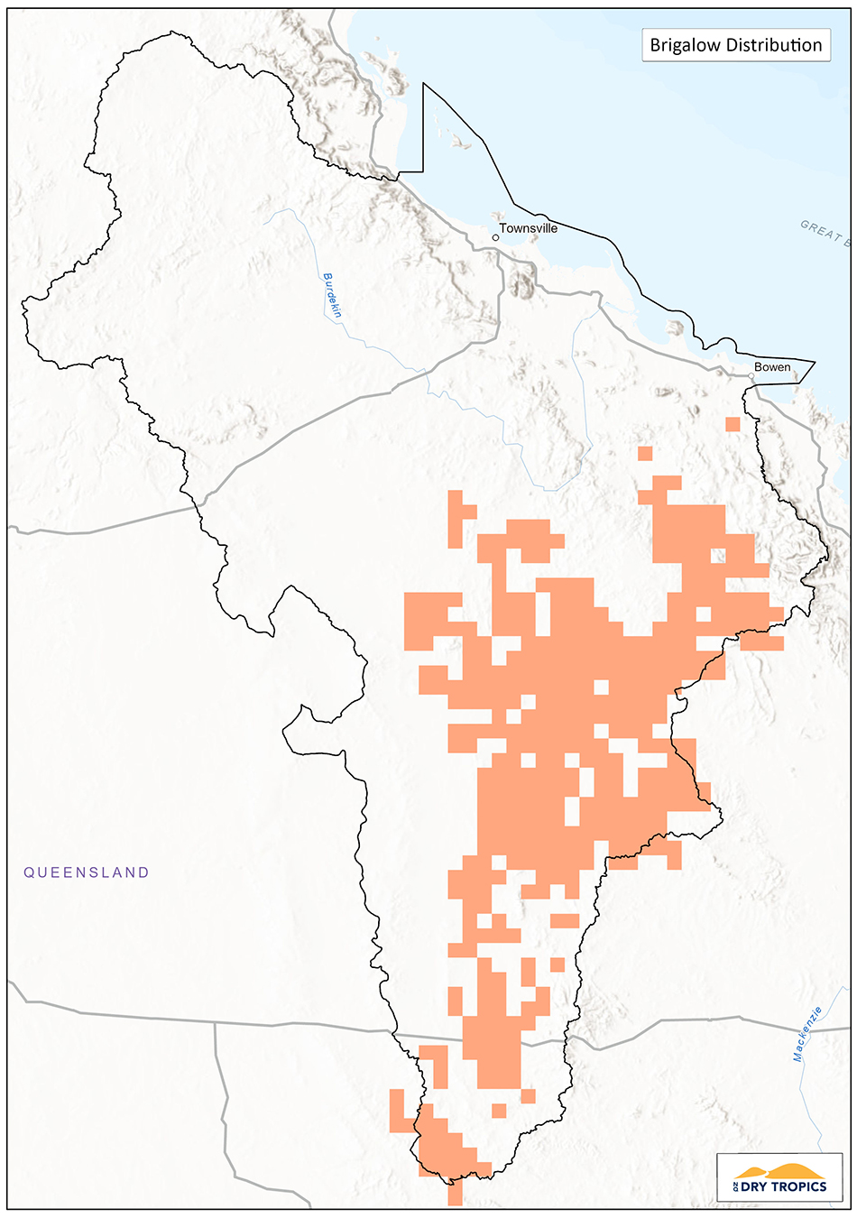
The Brigalow Belt bioregion is band of acacia woodland and grassland that stretches from the QLD-NSW border to Townsville at the most northern extent. Remnants of Brigalow in Queensland are found in this bioregion. The community is classified as Endangered, as it has declined to about 10 per cent of its former range. There is no adopted or made Recovery Plan for this community.
In the Burdekin Dry Tropics region, Brigalow is found in the Cape River Hills, Belyando Downs, Bogie River Hills, Broken River, Townsville Plains and Upper Belyando Floodout subregions.
The Brigalow Ecological community has become threatened primarily through clearing. As the species occurs primarily on agricultural land clearing has been undertaken predominantly for purposes of increasing pasture area for grazing in the Burdekin Dry Tropics region. Historically, much of this clearing was encouraged and incentivised. While this species does produce seeds, new recruitment is usually through suckers from the roots of existing trees. This can produce dense areas of Brigalow (whipstick Brigalow), which can prevent pasture from growing and access for cattle, leading to repeated clearing of Brigalow dominated vegetation. These areas of regrowth also do not have the ecological value of original, uncleared remnants. Remnant areas of Brigalow are now under threat by high-intensity fires, weeds and pest animals.
Brigalow communities provide habitat for 17 species that are threatened in Queensland, or nationally, many of them rare reptiles. Some species found in Queensland brigalow include: the ornamental snake, brigalow scaly-foot, glossy-black cockatoo, painted honeyeater, spotted bowerbird, and the rare pale imperial hairstreak butterfly.
 Current Projects:
Project Name: Conserving Brigalow Corridors
Project Duration: 2018 – 2023
Managed by: NQ Dry Tropics
Funding Program: Regional Land Partnerships
Project website: Conserving-brigalow-corridors/
Summary: This project is meeting the Five Year Outcome of ‘By 2023, the implementation of priority actions is leading to an improvement in the condition of EPBC Act listed Threatened Ecological Communities’ by working with landholders in the Suttor region to address threats to the condition of Brigalow community remnants on their properties, such as pests and weeds, in accordance with the Queensland Governments Brigalow management guidelines.
Key Collaborators
This list does not cover all groups or organisations, but rather represents the ‘key’ organisations and groups whose assistance, advice, approval or cooperation would be required to work on the Brigalow Threatened Ecological Community in the Burdekin Dry Tropics region.
- Department of Agriculture, Water and Environment (DAWE).
- Queensland Department of Environment and Science.
- Landholder s and managers (for work on privately held properties).
- Traditional Owners – check.
- NQ Dry Tropics (regional NRM group).
 Monitoring:
There are currently no monitoring programs underway for the Brigalow community, outside that undertaken for specific projects.
- Potential indicators for Brigalow communities include:
- Size, condition and functionality of remnants.
- Connectivity of remnants.
- Presence of habitat features for key species
- Presence and abundance of key species.
- Threat level and management.
Links and further information:
- Species Profile and Threats Database (SPRAT) – https://www.environment.gov.au/cgi-bin/sprat/public/publicshowcommunity.pl?id=28
- Queensland Department of Environment and Science – Biodiversity Planning Assessment for the Brigalow Belt Bioregion – https://www.qld.gov.au/__data/assets/pdf_file/0029/68186/bb-bpa-summary-report.pdf
- Queensland Government Brigalow Management Guides – https://www.qld.gov.au/environment/plants-animals/habitats/regrowth/regrowth-guides/brigalow
- Department of Agriculture, Water and Environment – Brigalow Belt North Bioregion – https://www.environment.gov.au/system/files/resources/a8015c25-4aa2-4833-ad9c-e98d09e2ab52/files/bioregion-brigalow-belt-north.pdf
- Threatened Species Scientific Committee – Conservation Advice – http://www.environment.gov.au/node/14496
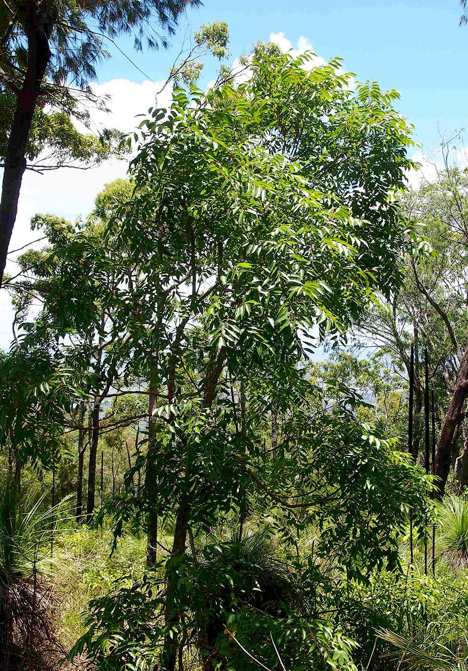
Broad leaf tea-tree woodlands in high rainfall coastal north Queensland
 (Melaleuca viridiflora)
Status: Endangered – Environment Protection and Biodiversity Conservation Act 1999 (EPBC Act).
Conservation Advice: There an Approved Conservation Advice for this ecological community (2012),
Recovery Plan: There no adopted or made Recovery Plan for this ecological community.
Threat Abatement Plan: There is one Threat Abatement Plan for this ecological community (Phytophthora).
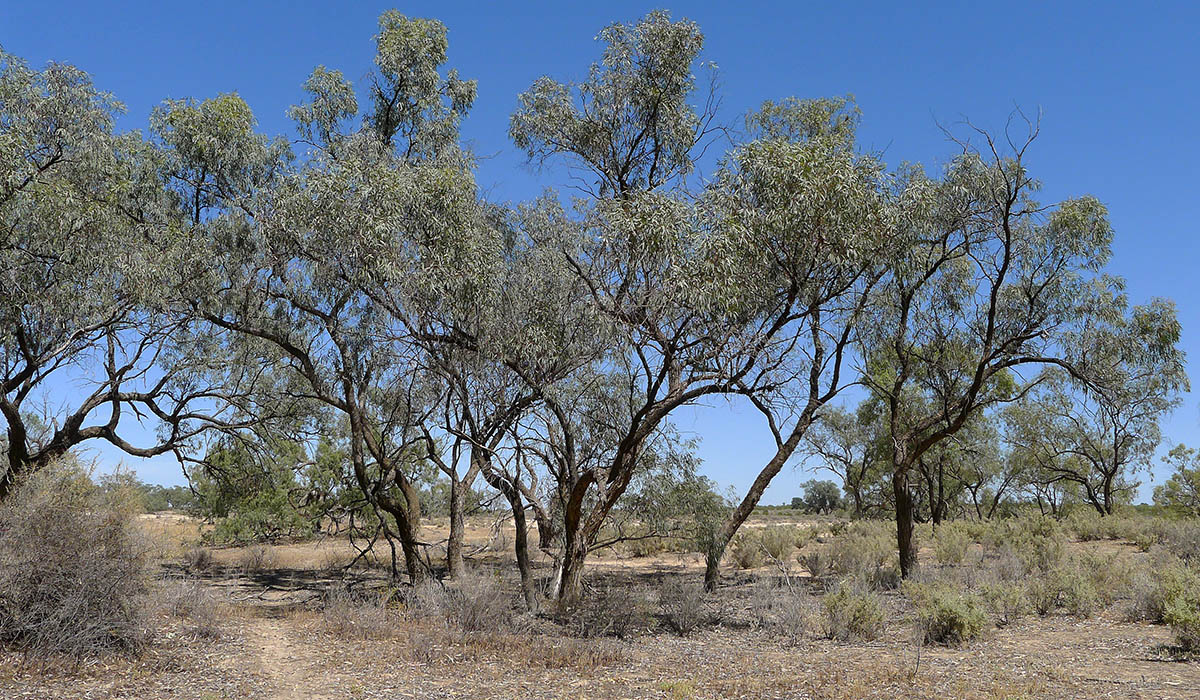
Melaleuca viridiflora is a native Australian species of myrtle, with the common name of Broad-leaf tea-tree or Broad-leaf paperbark. It normally grows to a height of around 10m and is found in areas that receive monsoonal rain and remain wet such as swamps, waterways and woodlands. It is characterised by paper-like bark and flowers that are of the typical size and structure of melaleuca species, however flowers can be cream, yellow, yellow-green or occasionally red.
The key defining attributes for the ecological community are:
- it occurs in the Wet Tropics and Central Mackay Coast bioregions in landscapes characterised by high rainfall and near coastal or floodplain locations;
- sites are seasonally inundated during the wet season but are not permanently waterlogged;
- the tree canopy is clearly dominated (i.e. more than 50% of canopy cover) by Melaleuca viridiflora;
- a shrub layer is typically absent or sparse (juvenile canopy species and/or a conspicuous layer of Xanthorrhoea (grass tree) may sometimes be present); and
- there is a diverse ground-layer of grasses, sedges and forbs which includes species listed under the Description section.
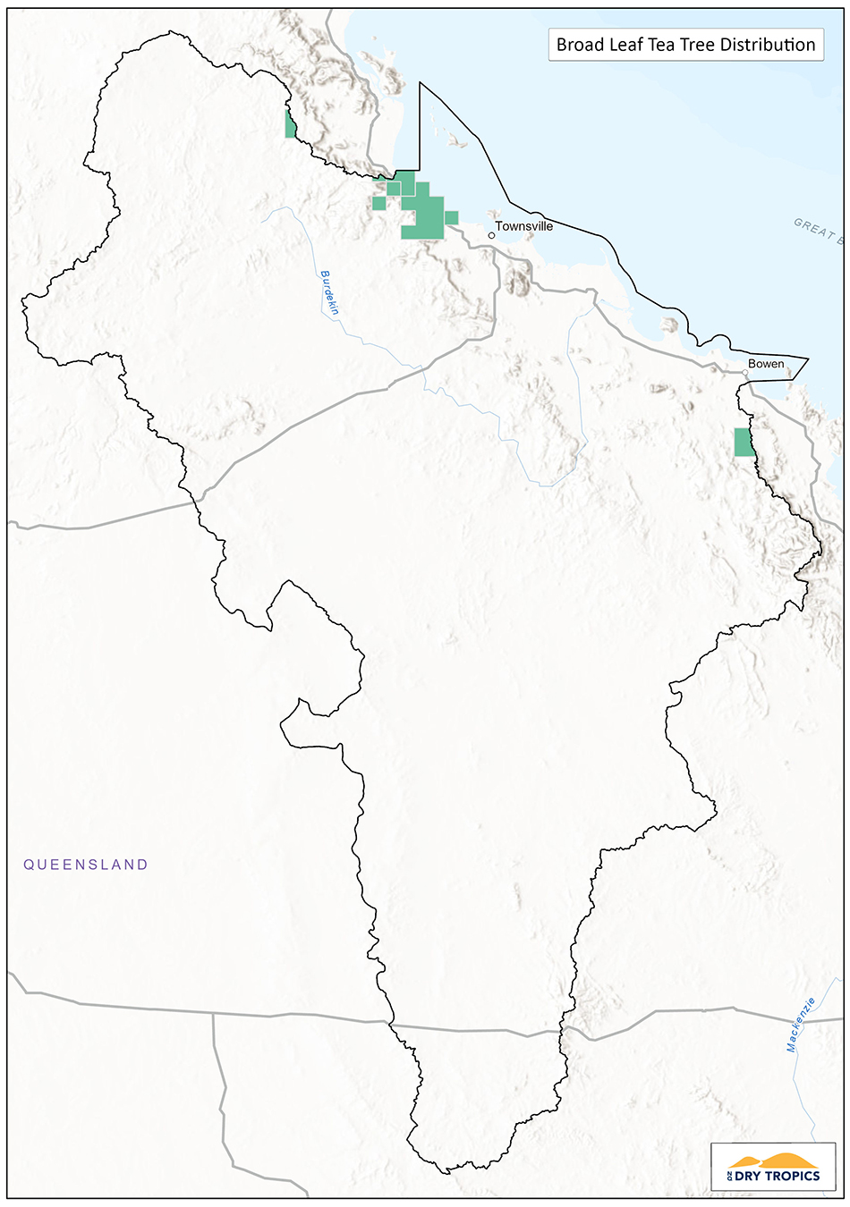 In the Burdekin Dry Tropics region, Broad leaf tea-tree is found in the southern-most area of the region (between Bowen and Mackay) and in the northern most area that encompasses the Wet Tropics.
The community has become threatened initially through clearing for agriculture, however, while there is no longer widespread clearing, habitat fragmentation through clearing of smaller areas remains a threat and weeds, inappropriate fire regimes, feral animals and disease threaten the condition of the remnant areas. The total reduction of the community is estimated at 71%, with 77% of the remaining patches are less than 10ha in size.
Broad leaf tea-tree woodlands are known to provide habitat for a range of flora and fauna species, some of which are also endangered, including several species of orchid and when flowering, the Broad leaf tea-tree is an important source of nectar for native species.
Current Projects
There are currently no projects being undertaken in Broad-leaf tea-tree in the Burdekin Dry Tropics region.
Key Collaborators
This list does not cover all groups or organisations, but rather represents the ‘key’ organisations and groups whose assistance, advice, approval or cooperation would be required to work on the Broad leaf tea-tree Threatened Ecological Community in the Burdekin Dry Tropics region:
- Department of Agriculture, Water and Environment (DAWE)
- Queensland Department of Environment and Science
- Landholder / managers (for work on privately held properties)
- Gia, Juru and Birriah Traditional Owners
- NQ Dry Tropics (regional NRM group)
Monitoring
There are currently no monitoring programs underway for the Broad leaf tea-tree community, outside that undertaken for specific projects.
Potential indicators for Broad-leaf tea-tree communities include:
- Size, condition and functionality of remnants
- Connectivity of remnants
- Presence of habitat features for key species
- Presence and abundance of key species
- Threat level and management
Links and further information:
- Burdekin Dry Tropics Conservation Action Planning Summary Report
- Species Profile and Threats Database (SPRAT) – https://www.environment.gov.au/cgi-bin/sprat/public/publicshowcommunity.pl?id=122&status=Endangered
- Conservation Advice – http://www.environment.gov.au/biodiversity/threatened/communities/pubs/122-conservation-advice.pdf
- Listing Advice – http://www.environment.gov.au/biodiversity/threatened/communities/pubs/122-listing-advice.pdf
- Fact sheet – https://www.environment.gov.au/system/files/resources/882adf7f-38d1-40d8-a62f-8d33b4fc0a6e/files/broad-leaf-tea-tree-and-landholders.pdf
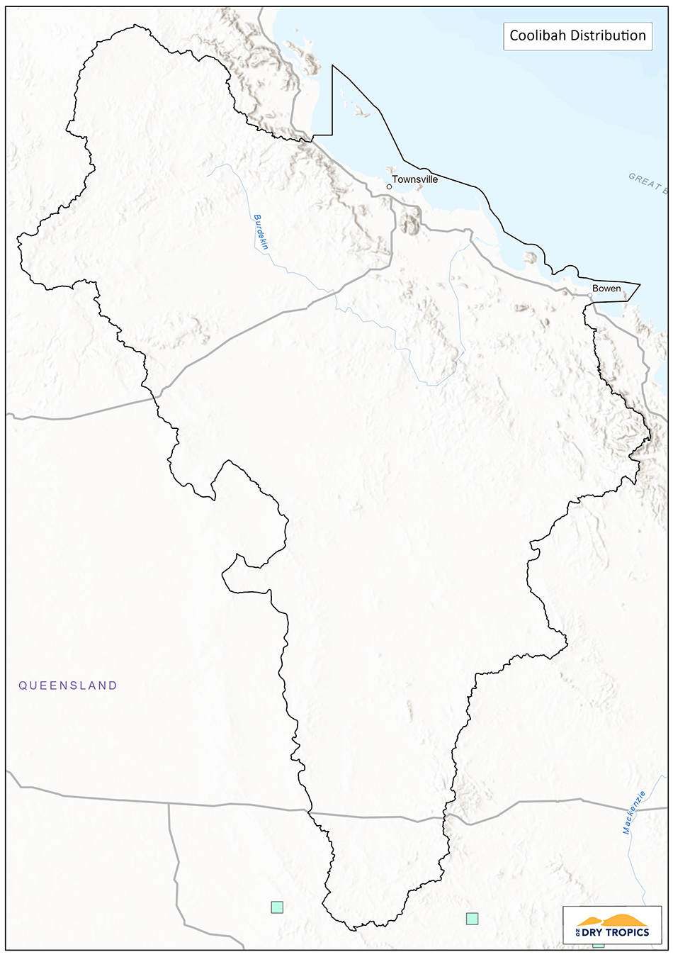
Coolibah – Black Box Woodlands of the Darling Riverine Plains and the Brigalow Belt South Bioregions
Status: Endangered – Environment Protection and Biodiversity Conservation Act 1999 (EPBC Act).
Conservation Advice: There an Approved Conservation Advice for this ecological community (2011).
Recovery Plan: There no adopted or made Recovery Plan for this ecological community.
Threat Abatement Plan: There are no Threat Abatement Plans identified as relevant for this ecological community.
Coolibah – Black Box woodlands are open, sub-tropical woodland that are dominated by Eucalyptus coolabah and may be co-occuring with Eucalyptus largiflorens (Black Box). The range of potential occurrence of this type of woodland extends from the Brigalow Belt South (with the most northerly extension just north of Rockhampton) and extending down to the NSW border. The canopy ranges from 5 – 15m high and other species of eucalypt, acacia and casuarina may be present. The woodland also includes a shrub layer and grassland and is home to a wide variety of fauna that utilise woodlands, particularly those species that require tree hollows.
 The key diagnostic attributes for the Coolibah – Black Box Woodlands of the Darling Riverine Plains and the Brigalow Belt South Bioregions ecological community are as follows:
- Distribution is limited to the Darling Riverine Plains and the Brigalow Belt South bioregions
- It typically occurs on the grey, self-mulching clays of periodically waterlogged floodplains, swamp margins, ephemeral wetlands and stream levees.
- A tree canopy layer is present that shows these features:
-
- Eucalyptus coolabah subsp. coolabah (Coolibah) must be present in the tree canopy;
- Coolibah typically is dominant (≥50% of tree crown cover);
- Where Coolibah and E. largiflorens (Black Box) co-occur, together they make up the dominant species in the tree canopy layer (≥50% of tree crown cover);
- Hybrids of Coolibah or Black Box with each other and other Eucalyptus species (typically Bimble Box) are included as dominant tree species.
- The mid or shrub layer may or may not be present. When present it is typically sparse or clumped and is of variable composition.
- The ground layer is of variable composition and cover ranging from sparse to dense. Ground cover lifeforms typically comprise native graminoids, other herbs, chenopods and other low shrubs that are typically under 50 cm tall.
This ecological community has become threatened due to clearing and fragmentation, changes to water flows and patterns, inappropriate grazing regimes, invasion of exotic species and low levels of protection within reserves. Future threats are further clearing and fragmentation, further changes to water flows and patterns from infrastructure and water storage for irrigation and the impacts of climate change.
Although the most northerly section of the Brigalow Belt South is in the lower area of the Burdekin Dry Tropics, there are no records of Coolibah-Black Box woodlands in this area.
Current Projects
There are currently no projects being undertaken in Broad-leaf tea-tree in the Burdekin Dry Tropics region.
Key Collaborators
This list does not cover all groups or organisations, but rather represents the ‘key’ organisations and groups whose assistance, advice, approval or cooperation would be required to work on the Broad leaf tea-tree Threatened Ecological Community in the Burdekin Dry Tropics region:
- Department of Agriculture, Water and Environment (DAWE)
- Queensland Department of Environment and Science
- Landholder / managers (for work on privately held properties)
- Traditional Owners – check
- NQ Dry Tropics (regional NRM group)
Monitoring
There are currently no monitoring programs underway for the Broad leaf tea-tree community, outside that undertaken for specific projects.
Potential indicators for Broad-leaf tea-tree communities include:
- Size, condition and functionality of remnants
- Connectivity of remnants
- Presence of habitat features for key species
- Presence and abundance of key species
- Threat level and management
Links and further information:
- Species Profile and Threats Database (SPRAT) – https://www.environment.gov.au/cgi-bin/sprat/public/publicshowcommunity.pl?id=122&status=Endangered
- Conservation Advice – http://www.environment.gov.au/biodiversity/threatened/communities/pubs/122-conservation-advice.pdf
- Listing Advice – http://www.environment.gov.au/biodiversity/threatened/communities/pubs/122-listing-advice.pdf
- Fact sheet – https://www.environment.gov.au/system/files/resources/882adf7f-38d1-40d8-a62f-8d33b4fc0a6e/files/broad-leaf-tea-tree-and-landholders.pdf
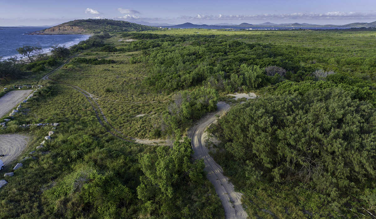
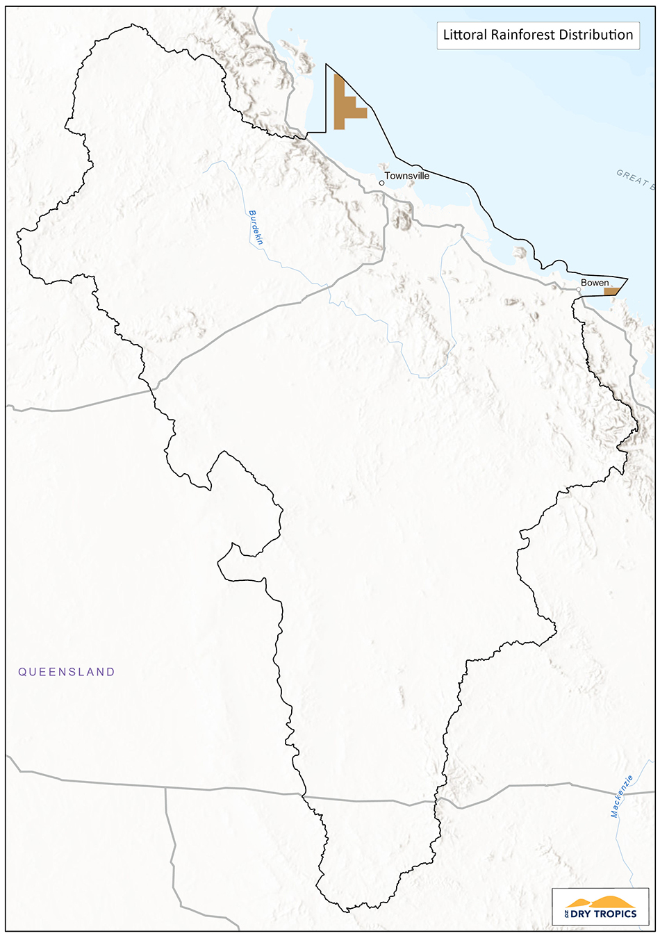
Littoral Rainforest and Coastal Vine Thickets of Eastern Australia
Status: Critically Endangered – Environment Protection and Biodiversity Conservation Act 1999 (EPBC Act).
Conservation Advice: There an Approved Conservation Advice for this ecological community (2015).
Recovery Plan: There is a National Recovery Plan for this ecological community.
Threat Abatement Plan: There is one Threat Abatement Plan identified as relevant for this ecological community (Cane toads).
Littoral (meaning on the shore) Rainforest and Coastal Vine Thickets ecological community is a complex of rainforest and coastal vine thickets on the east coast of Australia. It typically occurs within two kilometres of the coast or adjacent to a large salt water body, such as an estuary and so is strongly influenced by its proximity to the sea and the saline nature of the location. It is distributed as a series of unconnected, localised stands and can be found on a variety of soil types and geographic features. It is spread along the eastern coast of Australia, including off-shore islands, from the south-eastern corner in Victoria, up to the Cape York peninsula, north of Cooktown. As the community is spread over a wide geographical range, the diversity, height and structure of the vegetation is different between northern and southern communities.
The rainforest canopy helps to protect plants underneath it and within it from the effects of being so close to the coast, such as salty wind spray, however all areas are affected by the saline nature of the environment.
 Key Diagnostic Characteristics:
- The ecological community occurs in the following IBRA bioregions: Cape York Peninsula (from Princess Charlotte Bay southwards), Wet Tropics, Central Mackay Coast, South Eastern Queensland, NSW North Coast, Sydney Basin and South East Corner.
- Patches of the ecological community occur within two kilometres of the east coast, including offshore islands, or adjacent to a large body of salt water, such as an estuary, where they are subject to maritime influence.
- The structure of the ecological community typically is a closed canopy of trees that can be interspersed with canopy gaps that are common in exposed situations or with storm events. Usually, several vegetation strata are present. However, where there is extreme exposure to salt laden winds, these strata may merge into a height continuum rather than occurring as distinct vegetation layers. The canopy forms a mosaic due to canopy regeneration, typically in the form of basal coppice following canopy decapitation due to prevailing salt laden winds and storm events. Wind sheared canopy can be present on the frontal section leading to closed secondary canopies. Emergents may be present. The ground stratum of the vegetation typically is very sparse.
- The ecological community contains a range of plant life forms including trees, shrubs, vines, herbs, ferns and epiphytes. To the north, most plant species diversity is in the tree and shrub (i.e. canopy) layers rather than in lower strata. Feather palms, fan palms, large leaved vascular epiphytes and species that exhibit buttressing are generally rare. Ground ferns and vascular epiphytes are lower in diversity in littoral rainforests compared to most other rainforest types.
- Plants with xeromorphic and succulent features are generally more common in littoral rainforest than in hinterland rainforest types. Canopy stem sizes also tend to be smaller compared to that in hinterland rainforest. Trunks rarely host mosses though lichens are usually common.
- Whilst species can be regionally predictable, there may be considerable variation in the composition of individual stands of the ecological community within any given bioregion.
This ecological community provides habitat for a range of fauna including the Southern Cassowary and the Grey-headed Flying Fox.
This ecological community has become threatened due to primarily to its coastal location and pressures arising, including sand mining, clearing for agriculture and urban development, human impacts from visitation and recreation, weed incursion, feral animals and inappropriate fire regimes. The community is also vulnerable to the effects of climate change and is also subject to natural disturbance from storms and cyclones. The nature of the ecological community – being naturally fragmented and located in a narrow strip adjacent to shorelines also contributes to the vulnerability of this ecological community.
Current Projects:
Project Name: Protecting Beach Scrub.
Project Duration: 2018 – 2023.
Managed by: NQ Dry Tropics.
Funding Program: Regional Land Partnerships.
Project website: protecting-beach-scrub/
Summary: This project is meeting the Five Year Outcome of ‘By 2023, the implementation of priority actions is leading to an improvement in the condition of EPBC Act listed Threatened Ecological Communities’ by working in Beach Scrub remnants along the coastline of the region and off-shore islands to reduce threats from weeds, feral animals and human disturbance. This project works with local councils, landcare groups and Traditional Owner groups to manage and monitor these threats.
Key Collaborators
This list does not cover all groups or organisations, but rather represents the ‘key’ organisations and groups whose assistance, advice, approval or cooperation would be required to work on this Threatened Ecological Community.
- Department of Agriculture, Water and Environment (DAWE)
- Queensland Department of Environment and Science
- Queensland National Parks and Wildlife Service
- Landholder / managers (for work on privately held properties)
- Townsville City Council
- Whitsunday Regional Council
- Palm Island Aboriginal Shire Council
- Manbarra, Wulgurukaba, Bindal and Juru Traditional Owner groups
- NQ Dry Tropics
Monitoring:
There are currently no monitoring programs underway for this ecological community, outside that undertaken for specific projects.
Potential indicators for this ecological community include:
- Size, condition and functionality of remnants
- Presence of habitat features for key species
- Presence and abundance of key species
- Threat level and management
Links and further information:
- Species Profile and Threats Database (SPRAT) – https://www.environment.gov.au/cgi-bin/sprat/public/publicshowcommunity.pl?id=76&status=Critically+Endangered
- Conservation Advice – http://www.environment.gov.au/biodiversity/threatened/communities/pubs/76-conservation-advice-12112015.pdf
- Listing Advice – http://www.environment.gov.au/biodiversity/threatened/communities/pubs/76-listing-advice.pdf
- National Recovery Plan – http://www.environment.gov.au/biodiversity/threatened/publications/recovery/littoral-rainforest-coastal-vine-thickets
- Information sheet – https://www.environment.gov.au/system/files/resources/19747170-3fd3-4930-9ca5-6ca89508b571/files/littoral-rainforest.pdf
- Northern Australian Environmental Resources Hub – Mapping to underpin management of tropical littoral rainforest – https://www.nespnorthern.edu.au/projects/nesp/mapping-to-underpin-management-of-tropical-littoral-rainforest/
Natural Grasslands of the Queensland Central Highlands and northern Fitzroy Basin
Status: Endangered – Environment Protection and Biodiversity Conservation Act 1999 (EPBC Act).
Conservation Advice: There an Approved Conservation Advice for this ecological community (2008).
Recovery Plan: There is no adopted or made Recovery Plan for this ecological community.
Threat Abatement Plan: There is one Threat Abatement Plan identified as relevant for this ecological community (Cane toads)
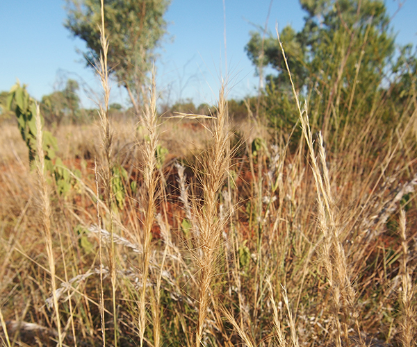
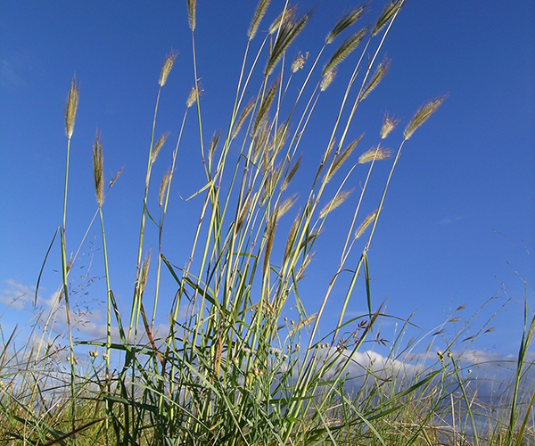
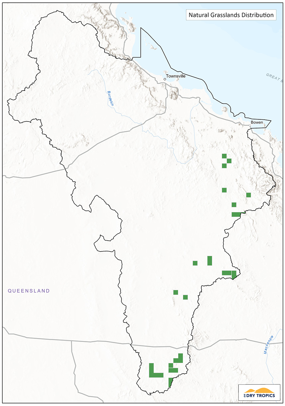 Natural grasslands of the Queensland Central Highlands and northern Fitzroy Basin are grasslands that are characterised by native tussock grasses and a low level of tree canopy cover (less than 10%) and are normally found on areas that are flat to generally undulating. The soil is typically basalt or cracking clay and the soil, along with other factors such as fire and frost may also contribute to the overall lack of trees.
Species of native grasses found in this ecological community include Bluegrasses, Three-awned grasses, Panic grasses and Mitchell grass species. The grassland also includes forb species such as Scurvy Grass, Native Jute and Cow Vine. A shrub layer of acacia species, along with others may be present.
Grasslands provide important habitat for foraging and feeding, including for granivorous species such as quail and for birds of prey such as falcons, kites and harriers. Planigales, a small, carnivorous and nocturnal marsupial are also found in these grasslands.
Key Diagnostic Characteristics:
- Distribution: It occurs within the Brigalow Belt North and South, which are largely within the Central Highlands and northern Fitzroy River Basin regions of Queensland;
- Tree canopy absent or sparse (less than 10% projective crown cover). If it can be demonstrated, beyond reasonable doubt, that the grassland was derived from cleared woodland then it is not part of the national ecological community; and,
- The ground layer is typically dominated by perennial native grasses and contains at least 3 of the indicator native species listed below:
| Aristida latifolia | Feather-top Wiregrass |
| Aristida leptopoda | White Speargrass |
| Astrebla elymoides | Hoop Mitchell Grass |
| Astrebla lappacea | Curly Mitchell Grass |
| Astrebla squarrosa | Bull Mitchell Grass |
| Bothriochloa erianthoides | Satin-top Grass |
| Dichanthium queenslandicum | King Bluegrass |
| Dichanthium sericeum | Queensland Bluegrass |
| Eriochloa crebra | Cup Grass |
| Panicum decompositum | Native Millet |
| Panicum queenslandicum | Yabila Grass |
| Paspalidium globoideum | Shot Grass |
| Thellungia advena | Coolibah Grass |
This ecological community has become threatened due to grazing, cropping and pasture improvement, weeds, pest animals, mining, construction of roads and other infrastructure. Potential threats are identified as climate change and lack of knowledge.The ecological community is found only in Queensland, in the Brigalow Belt North and South. In the Burdekin Dry Tropics region, this grassland ecological community occurs within the Brigalow Belt North bioregion, in the southern area of the region, from Collinsville and extending south to the border with Fitzroy Basin NRM.
Current Projects:
There are currently no projects funded by the NLP2 program taking place in this ecological community in the Burdekin Dry Tropics region.
Key Collaborators
This list does not cover all groups or organisations, but rather represents the ‘key’ organisations and groups whose assistance, advice, approval or cooperation would be required to work on this Threatened Ecological Community:
- Department of Agriculture, Water and Environment (DAWE).
- Queensland Department of Environment and Science.
- Queensland National Parks and Wildlife Service.
- Landholder / managers (for work on privately held properties).
- Birriah, Jangga, Wangan/Jagalingou and Bidjara Traditional Owner groups.
- NQ Dry Tropics.
- Fitzroy Basin NRM.
Monitoring:
There are currently no monitoring programs underway for this ecological community, outside that undertaken for specific projects. Some monitoring may occur where mining has an impact on the ecological community.
Potential indicators for this ecological community include:
- Size, condition and functionality of remnants.
- Presence of habitat features for key species.
- Presence and abundance of key species.
- Threat level and management.
Links and further information:
- Burdekin Dry Tropics Conservation Action Planning Summary Report
- Species Profile and Threats Database (SPRAT) – https://www.environment.gov.au/cgi-bin/sprat/public/publicshowcommunity.pl?id=99&status=Endangered
- Conservation Advice – http://www.environment.gov.au/biodiversity/threatened/communities/pubs/99-conservation-advice.pdf
- Listing Advice – http://www.environment.gov.au/biodiversity/threatened/communities/pubs/99-listing-advice.pdf
- Department of Environment, Water and Environment – Guide – http://www.environment.gov.au/system/files/resources/347c5d4e-cef8-411c-b53c-bed3ed1d3e1c/files/bio237-0512-natural-grasslands-guide.pdf
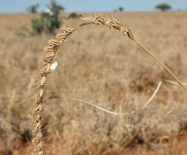
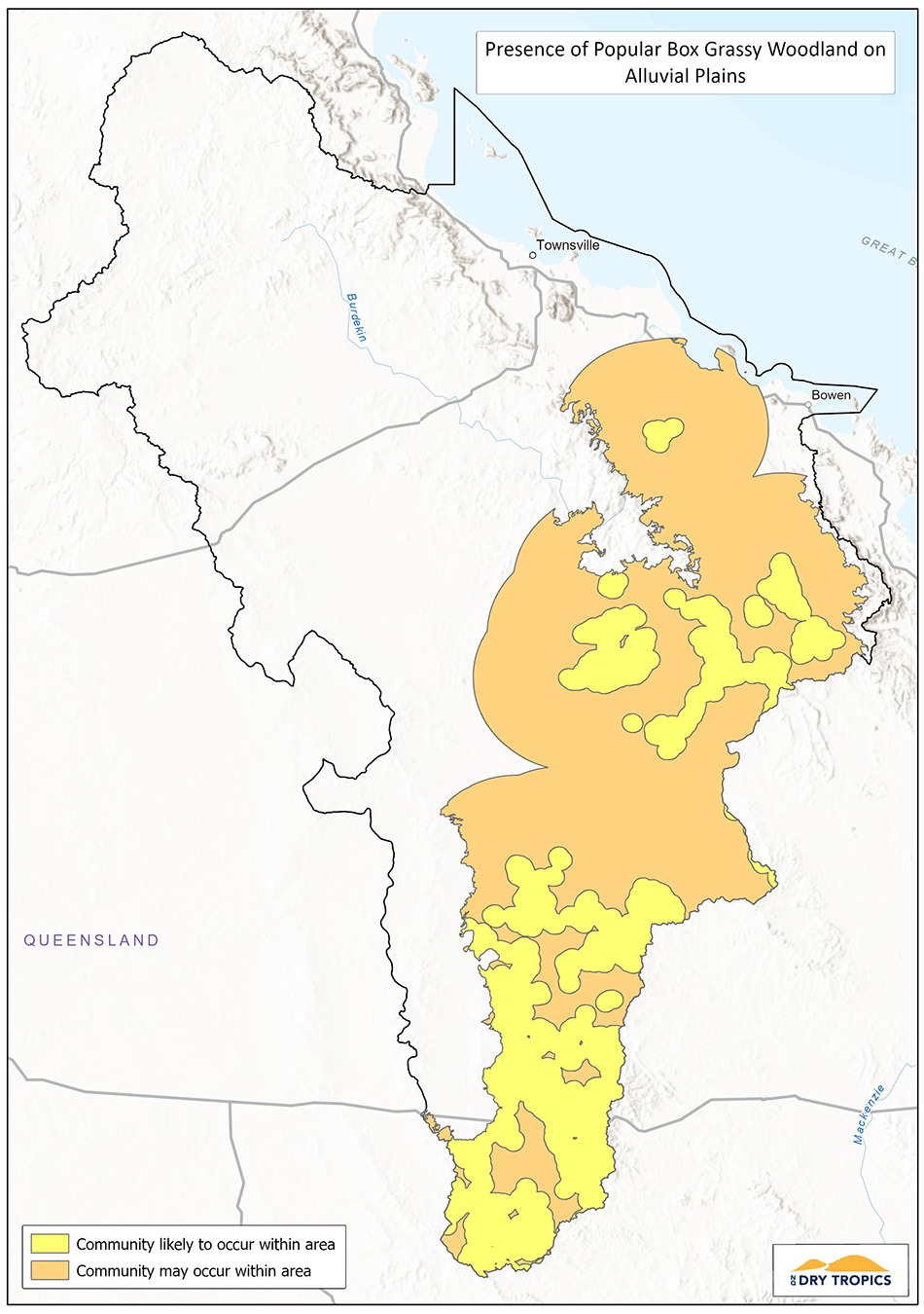
Poplar Box Grassy Woodland on Alluvial Plains
 Status: Endangered – Environment Protection and Biodiversity Conservation Act 1999 (EPBC Act).
Conservation Advice: There an Approved Conservation Advice for this ecological community (2019).
Recovery Plan: There is no adopted or made Recovery Plan for this ecological community (Plan not required – sufficient information in the Approved Conservation Advice).
Threat Abatement Plan: No Threat Abatement Plan has been identified as being relevant for this ecological community.
Poplar Box grassy woodland on alluvial plains is typically an open, grassy woodland found west of the Great Dividing Range. The canopy is dominated by Poplar Box (Eucalyptus populnea) with a canopy height of 10-20m. As the name of the ecological community suggests, it is found on alluvial plains, both active and historic and therefore is found in flat to gently undulating areas. This type of woodland blends into other woodland and grassland types. Other species of eucalypt may be present, along with cedar and casuarina species.
Shrubs and a light understory may be present and the grass layer is dominated by native grass species, with the composition dependent on location and soil type.
This ecological community supports a wide range of native animals that utilise grasslands e.g. kangaroos and woodlands e.g. koalas. Additionally, the provision of tree hollows is particularly important for species that use hollows for protection and rearing young. Native grasses and the flowering of the eucalypt species provide an important food source for herbivorous, granivorous and nectivorous species, as well as the species that prey on them.
 Key Diagnostic Characteristics
Location and physical environment:
- Occurs in the Brigalow Belt North, Brigalow Belt South, Southeast Queensland, Cobar Peneplains, Darling Riverine Plains, NSW South Western Slopes, Riverina and Murray Darling Depression IBRA bioregions.
- Associated with ancient and recent depositional alluvial plains with clay, clay-loam, loam and sandy loam, typically duplex soils or sodosols. This includes areas that may not be part of currently defined floodplains.
Structure:
- A grassy woodland to grassy open woodland with a tree crown cover11 of 10% or more at patch scale.
- A tree canopy must be present that shows these features: o Canopy tree species are capable of reaching 10 m or more in height;
- Eucalyptus populnea (Poplar Box) must be present in the canopy and is the dominant12 tree species;
- Where hybrids of Poplar Box with other Eucalyptus spp are present, they should be counted as part of the Eucalyptus populnea component of the tree canopy when assessing the previous criterion.
- Mid layer (1-10 m) crown cover of shrubs to small trees13 is low, about 30% or less.
There has been a 70% decline in this woodland across its range. As it is typically found in areas used for agriculture, many of the causes for its decline and threats to its current distribution and condition are related to the impacts of agriculture. Threats include; clearing and fragmentation, inappropriate fire and grazing regimes, dieback, chemical impact and spray drift, disturbance of soils and hydrological changes (changed ground water levels, increased salinity, nutrient enrichment), weeds and pest species and climate change.
The ecological community is found in NSW and Queensland, west of the Great Dividing Range. In the Burdekin Dry Tropics it is found in the Brigalow Belt North, in the southern areas of the region, roughly between Collinsville and Alpha.
Current Projects:
There are currently no projects funded by the NLP2 program taking place in this ecological community in the Burdekin Dry Tropics region.
Key Collaborators
This list does not cover all groups or organisations, but rather represents the ‘key’ organisations and groups whose assistance, advice, approval or cooperation would be required to work on this Threatened Ecological Community:
- Department of Agriculture, Water and Environment (DAWE).
- Queensland Department of Environment and Science.
- Queensland National Parks and Wildlife Service.
- Landholder / managers (for work on privately held properties).
- Traditional Owner groups – Bindal, check.
- NQ Dry Tropics.
- Fitzroy Basin NRM.
Monitoring:
There are currently no monitoring programs underway for this ecological community, outside that undertaken for specific projects. Some monitoring may occur where mining has an impact on the ecological community.
Potential indicators for this ecological community include:
- Size, condition and functionality of remnants
- Presence of habitat features for key species
- Presence and abundance of key species
- Threat level and management
Links and further information:
-
- Species Profile and Threats Database (SPRAT) – https://www.environment.gov.au/cgi-bin/sprat/public/publicshowcommunity.pl?id=141
- Conservation Advice – http://www.environment.gov.au/biodiversity/threatened/communities/pubs/141pb-conservation-advice.pdf
- Proposal to list as a nationally threatened community – https://www.environment.gov.au/system/files/consultations/953749e8-2d05-4772-8220-152859f440d7/files/poplar-box-grassy-woodland-alluvial-plains-consultation-guide.pdf
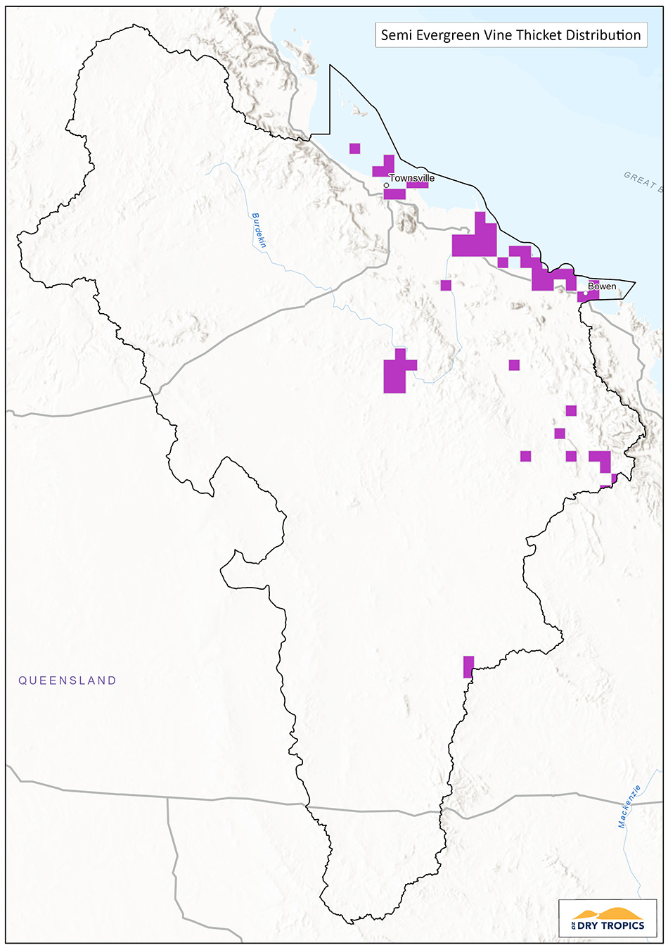 Semi-evergreen vine thickets of the Brigalow Belt (North and South) and Nandewar Bioregions
Status: Endangered – Environment Protection and Biodiversity Conservation Act 1999 (EPBC Act).
Conservation Advice: There is no Approved Conservation Advice for this ecological community.
Recovery Plan: There is an approved Recovery Plan for this ecological community (2001).
Threat Abatement Plan: There are two Threat Abatement Plans identified as being relevant for this ecological community (Cane toads and feral pigs).
Semi-evergreen thickets of the Brigalow Belt are a type of low, dense, sub-tropical (or ‘dry’) rainforest, that features vines, twining or scrambling plants. Trees and shrubs are also present and can vary in height, distribution and composition depending on location. This ecological community is sometimes referred to in Queensland as softwood scrub or bottle tree scrub. While eucalypt species may be present, the community is dominated by non-eucalypt vegetation, some of which is deciduous. It occurs in areas that are relatively protected from fire, with high nutrient soils (usually derived from basalt or other volcanic rocks).
This ecological community is home to a wide variety of native species including birds, mammals, reptiles and amphibians.
There are no listed Key Diagnostic Characteristics of this community, however broadly the following characteristics can be used for the northern distribution:
- Occurs in the Brigalow Belt North.
- The vegetation is low, dry ‘scrub’ with vines / twining / scrambling plants present.
The following species are present:
-
- Broad-leaved bottle tree.
- Yellow tulip.
- Small-leaved ebony.
- Helicopter tree.
- Brush wilga.
- Yellow lemon.
- Strychnine.
- Vine species – Cissus reniformis and Jasminum didymum.
Some species present are deciduous
The current distribution in the Brigalow Belt is estimated to be only 17% of what was present prior to European clearing. Clearing has occurred primarily for agriculture (grazing and cropping). Current threats include; clearing and fragmentation (for agriculture and development), inappropriate fire and grazing regimes, weeds and pest species.
This ecological community is found in the Brigalow Belt (North and South) and in northern areas of New South Wales. In the Burdekin Dry Tropics region, this ecological community is found in Townsville coastal areas and southern inland areas.
Current Projects:
There is currently a project funded by the NLP2 program taking place in this ecological community in the Burdekin Dry Tropics region, which is a combined project in with Littoral Rainforest and Coastal Vine Thickets of Eastern Australia ecological community (see Protecting Beach Scrub project above).
 Key Collaborators:
This list does not cover all groups or organisations, but rather represents the ‘key’ organisations and groups whose assistance, advice, approval or cooperation would be required to work on this Threatened Ecological Community.
- Department of Agriculture, Water and Environment (DAWE).
- Queensland Department of Environment and Science.
- Queensland National Parks and Wildlife Service.
- Landholder / managers (for work on privately held properties)
- Gudjal, Birriah, Jangga, Wangan/ Jagalingou Wulgurukaba, Bindal, Juru Traditional Owner groups
- Relevant local council
- NQ Dry Tropics.
- Fitzroy Basin NRM.
Monitoring:
There are currently no monitoring programs underway for this ecological community, outside that undertaken for specific projects. Some monitoring may occur where mining has an impact on the ecological community.
Potential indicators for this ecological community include:
- Size, condition and functionality of remnants
- Presence of habitat features for key species
- Presence and abundance of key species
- Threat level and management
Links and further information:
- Species Profile and Threats Database (SPRAT) – https://www.environment.gov.au/cgi-bin/sprat/public/publicshowcommunity.pl?id=24
- National Recovery Plan http://www.environment.gov.au/system/files/resources/7994b254-82ed-40cf-9985-29fa09138ff4/files/semi-evergreen-vine-thickets.pdf
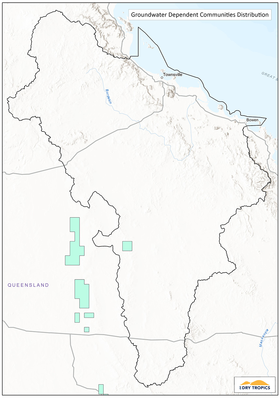 The community of native species dependent on natural discharge of groundwater from the Great Artesian Basin
Status: Endangered – Environment Protection and Biodiversity Conservation Act 1999 (EPBC Act).
Conservation Advice: There is no Approved Conservation Advice for this ecological community.
Recovery Plan: There an approved Recovery Plan for this ecological community (2010).
Threat Abatement Plan: There are two Threat Abatement Plans identified as being relevant for this ecological community (Cane toads and feral pigs).
The Great Artesian Basin is the largest underground aquifer in the world, underlying 22% of the continent, including large areas of NSW, South Australia and Queensland. In places, water from the GAB naturally discharges to the surface (springs), creating a wetland in an otherwise arid or semi-arid environment. These wetlands are distinguished by a lack of seasonality, due to the continual influx of water. Size and structure are highly variable, and water chemistry and substrate create differences in the floral composition.
There are no listed Key Diagnostic Characteristics of this community, however the following criteria apply:
- Natural surface discharge from the Great Artesian Basin, not including spring arising from Tertiary sediments and basalts.
- Discharge may be mound springs, mid springs, boggomoss springs, spring pools or groundwater seeps.
- Occurs mainly within the twelve ‘spring groups’ for the Basin
- Community is comprised of native species which depend on this natural discharge to exist.
- Community comprises combinations of native species, as well as endemic species.
These communities include a number of unique and endemic species, both flora and fauna, particularly those species that require a wetland environment and have low mobility over drier landscapes, such as snails, fish and crustaceans. Some of these species are also endangered. As these communities are geographically distinct and cover a small area, they are particularly vulnerable.
In the Burdekin Dry Tropics region, the eastern edge of the GAB runs along the western side of the region. Along the south-western border of the region there is the potential for these communities to be present.
The main threats to this ecological community are: Aquifer draw-down (through bores and extraction), excavation of springs, exotic plants and aquatic animals, stock and feral animal disturbance, tourist access, and water impoundment e.g. dams causing inundation of sites.

PHOTO: Tom Jefferson, Greenpeace
Current Projects:
There are currently no projects funded by the NLP2 program taking place in this ecological community in the Burdekin Dry Tropics.
Key Collaborators:
This list does not cover all groups or organisations, but rather represents the ‘key’ organisations and groups whose assistance, advice, approval or cooperation would be required to work on this Threatened Ecological Community.
- Department of Agriculture, Water and Environment (DAWE).
- Queensland Department of Environment and Science.
- Queensland National Parks and Wildlife Service.
- Landholder/managers (for work on privately held properties).
- Wangan/Jagalingou and Yirendali Traditional Owner groups.
- NQ Dry Tropics.
- Desert Channels NRM.
Monitoring:
There are currently no monitoring programs underway for this ecological community, outside that undertaken for specific projects. Some monitoring may occur where mining has an impact on the ecological community.
Potential indicators for this ecological community include:
- Size, condition and functionality of remnants.
- Water levels and chemistry.
- Presence of habitat features for key species.
- Presence and abundance of key species.
- Threat level and management.
Links and further information:
- Burdekin Dry Tropics Conservation Action Planning Summary Report.
- Species Profile and Threats Database (SPRAT) – https://www.environment.gov.au/cgi-bin/sprat/public/publicshowcommunity.pl?id=26
- National Recovery Plan – http://www.environment.gov.au/system/files/resources/0cefc83a-3854-4cff-9128-abc719d9f9b3/files/great-artesian-basin-ec.pdf
- Ecological and hydrogeological surveys of the Great Artesian Basin, Vols 1 & 2 – http://www.environment.gov.au/water/publications/great-artesian-basin-springs-survey-vol-1 http://www.environment.gov.au/node/37379
- Queensland Government Wetland Info – https://wetlandinfo.des.qld.gov.au/wetlands/facts-maps/water-resource-planning-area-great-artesian-basin-and-other-regional-aquifers/
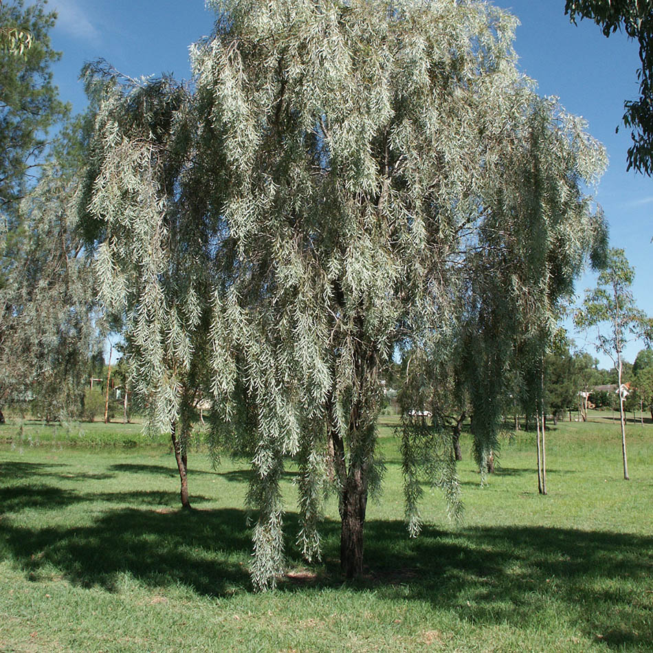
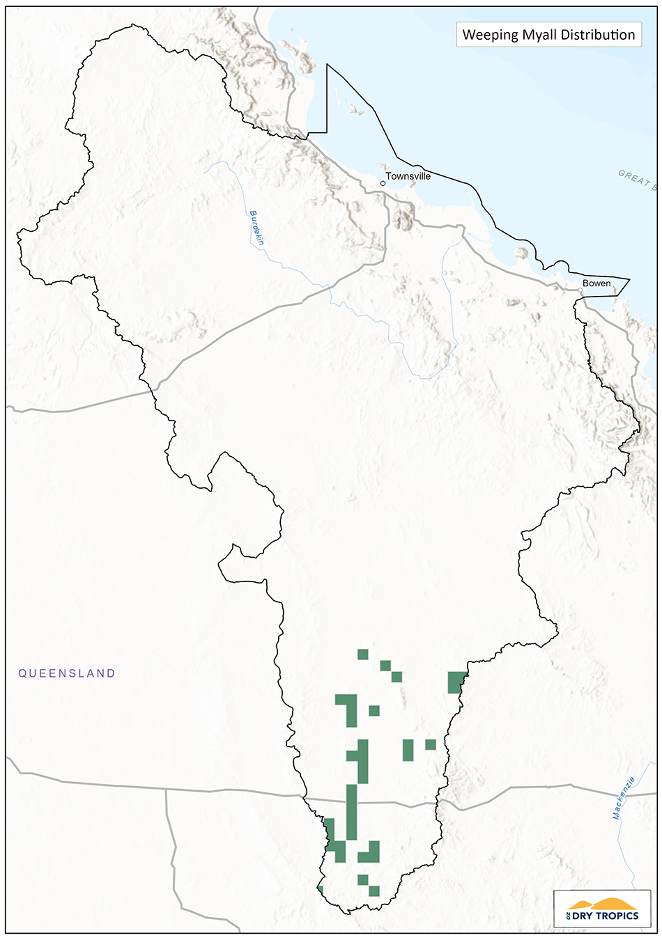 Weeping Myall Woodlands
Status: Endangered – Environment Protection and Biodiversity Conservation Act 1999 (EPBC Act).
Conservation Advice: There is an Approved Conservation Advice for this ecological community (2009).
Recovery Plan: There is no adopted or made Recovery Plan for this ecological community.
Threat Abatement Plan: There is one Threat Abatement Plans identified as being relevant for this ecological community (Cane toads).
Weeping Myall Woodlands are a woodland to open woodland that is dominated by Weeping Myall (Acacia pendula). Weeping Myall (also referred to as Myall, Boree, Balaar, Nilyah, Bastard Gidgee and Silver Leaf Boree) is a species of acacia that grows from 4-12m in height. It has distinctive silver-grey leaves and yellow flowers typical of wattle species. Weeping Myall woodlands typically have a native shrub and/or grass layer, in the northern region this includes Mitchell grass and Queensland Blue Grass. This community is found on alluvial plains, west of the Great Dividing Range.
There are no listed Key Diagnostic Characteristics of this community, however the following criteria apply for a remnant patch to be included in the listed ecological community:
- the tree canopy is dominated (at least 50% of trees present) by living, dead or defoliated Weeping Myall trees;
- the overstorey must have at least 5% tree canopy cover or at least 25 dead or defoliated mature Weeping Myall trees/ha;
- the area is at least 0.5ha in size; and
- the patch has either more than two layers of regeneration of Weeping Myall present; or the tallest layer of living, dead or defoliated Weeping Myall trees is at least 4 m tall and of the vegetative cover present, 50% is comprised of native species.
This community is thought to have occurred in a mosaic with other woodland and grassland communities, however due to agricultural activities it now remains as small patches, or in stretches that have not been cleared or heavily grazed e.g. travelling stock routes.
The range of this community stretches from a small area in Victoria, through NSW and into Queensland, in the Brigalow Belt North and South. There are no confirmed patches of this community in the Burdekin Dry Tropics region.
This community has been reduced by an estimated 75% in Queensland and many of the fragments that remain may not have sufficient condition to be recovered. The primary threat to this community is agricultural activities, as it lies in arable areas that are used for cropping and grazing. While some areas have been cleared by cropping (and remaining patches are under threat from cropping treatments such as fertiliser application and spray drift), many areas have been affected by grazing. Weeping Myall is a highly palatable species, preferred by cattle and therefore is cut to be fed, especially during times of drought. This palatability also means that young plants are grazed before reaching maturity. Therefore, conserving remaining patches will rely on appropriate grazing regimes that allow sufficient recruitment and lopping methods that do not compromise the condition of the trees.
 Current Projects:
There are currently no projects funded by the NLP2 program taking place in this ecological community in the Burdekin Dry Tropics.
Key Collaborators:
This list does not cover all groups or organisations, but rather represents the ‘key’ organisations and groups whose assistance, advice, approval or cooperation would be required to work on this Threatened Ecological Community.
- Department of Agriculture, Water and Environment (DAWE).
- Queensland Department of Environment and Science.
- Queensland National Parks and Wildlife Service.
- Landholder / managers (for work on privately held properties).
- Wangan/Jagalingou and Bidjara Traditional Owner groups .
- NQ Dry Tropics.
- Fitzroy Basin Association NRM.
Monitoring:
There are currently no monitoring programs underway for this ecological community, outside that undertaken for specific projects. Some monitoring may occur where mining has an impact on the ecological community.
Potential indicators for this ecological community include:
- Size, condition and functionality of remnants.
- Presence of habitat features for key species.
- Presence and abundance of key species.
- Threat level and management.
Links and further information:
- Species Profile and Threats Database (SPRAT) – https://www.environment.gov.au/cgi-bin/sprat/public/publicshowcommunity.pl?id=98
- Approved Conservation Advice – http://www.environment.gov.au/biodiversity/threatened/communities/pubs/98-conservation-advice.pdf
- Listing Advice http://www.environment.gov.au/biodiversity/threatened/communities/pubs/98-listing-advice.pdf