
Land Use Planning of the Burdekin Dry Tropics
Successful land use planning identifies the needs of the community while safeguarding natural resources. It occurs at multiple scales, from property planning through to local government area planning, regional planning and state-wide planning.
The Burdekin Dry Tropics covers an area of approximately 146,399km2 and includes part or all of 12 local government areas, each with its own local planning scheme. Unlike other parts of Queensland, there is no statutory regional plan for North Queensland, however, there is a North Queensland Regional Economic Development Plan 2014-2031, produced by the North Queensland Regional Organisation of Councils (Townsville City, Palm Island Shire, Hinchinbrook Shire, Burdekin Shire and Charters Towers Regional) (Regional Economic Development Sub-Committee, 2014).
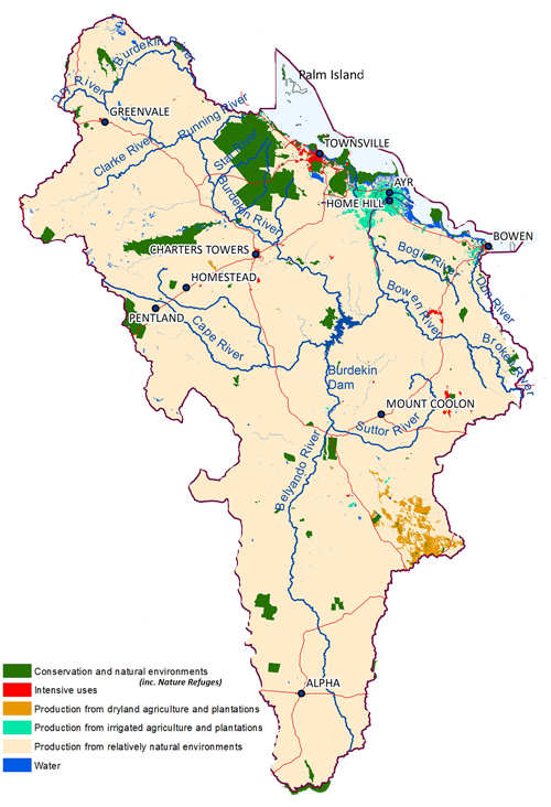
The major urban centers are located at Townsville, Charters Towers, Ayr, Home Hill and Bowen, however, the majority of our region is rural and supports a productive agricultural industry. Grazing occurs mostly in the rangelands, dryland cropping is widespread in the Belyando-Suttor and Bowen-Broken sub-catchments, and irrigated sugar cane production occurs in coastal areas (Department of Agricultural and Fisheries, 2013) (see map).
Native forest lands also occur in our region and are either managed as National Parks or state land for forestry, recreation and/or quarry material, including sand, gravel, road base, crushed aggregate and landscaping rock. The landscapes of our region also support a substantial mining industry, which produces coal, gold, silver and copper. There are about 330 granted mining leases in our region. Mining operations over the last 150 years have left a legacy of impacts and risks associated with around 2472 abandoned mine sites in our region (Department of Agricultural and Fisheries, 2013), (Queensland Department of Natural Resources and Mines, 2015).
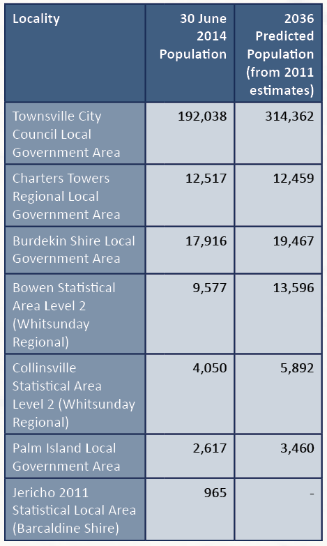
The Queensland Statistician’s Office has predicted a regional population growth of approximately 50 per cent over the next 20 years. See table below. As urban areas and services expand, they will encroach into rural lands and natural environments.
Land-use planning decisions must be made in a way that allocates land to its most appropriate use (Department of Natural Resources and Mines, 2013). This is determined by taking into consideration and balancing multiple interests, including the land’s attributes, government policies and community views.In addition to urban expansion, the rural community has expressed a desire to expand agricultural development throughout the region, particularly surrounding Ayr/Home Hill, Pentland, Belyando/Suttor (via water harvesting) Urannah and Collinsville. The Burdekin Dam provides unique opportunities to accommodate expansion and diversification, however, it also has a number of high-profile constraints around the allocation of water resources and downstream impacts, including the GBR catchment.
For example, decisions must balance the expansion of urban and agricultural land use with the need to protect natural areas that are environmentally sensitive. Protecting natural areas can be achieved by providing sufficient distance between developed and natural areas or areas that pose a hazard (for example: acid sulfate soils and flooding). This approach allows ecosystems to continue functioning whilst also protecting people and property from unnecessary risk.
Additionally, land resource attributes, such as fertile soils, need to be prioritised in land use decisions to ensure the long-term sustainability of the local agricultural economy. Decisions resulting in land being appropriately used lead to less conflict or cases of reverse amenity (in which existing land use impacts on newer land use or vice versa). In our region, planning and designing urban and agricultural expansion, also need to meet regional responsibilities to improve water quality and protect the GBR (Great Barrier Reef Marine Park Authority, 2014). Development and expansion should be done in a way that does not exceed environmental parameters, and maintains water quality, soil health and the surrounding natural environments. Appropriate waste management and planning, including sewage treatment and future land fill needs, are also vital to reduce the health impacts on the public and the receiving environments (Department of Environment and Heritage Protection, 2014). See Part C – Water for more regional information regarding waste treatment and Part C – Biodiversity for littering and illegal dumping.

Impacts resulting from land use can also come from further afield. Urban areas and major transport corridors increase the frequency of movement of people, animals and materials regionally, interstate or globally, and increases the risk of introducing pests and diseases. This also occurs when urban and peri-urban (rural residential) areas encroach into rural lands.
In urban environments, pests and diseases are mostly considered health issues, however, they are major threats that can migrate to adjacent rural and agricultural land where they can create ongoing pest management problems and have significant impacts on people’s businesses and the natural environment (Wadsworth & Choy, 2011). Rural land managers adjoining reserves or major watercourses have expressed concern about trespassers who drop litter, potentially spread weed seeds, contribute to land and riparian degradation, and compromise livestock welfare. They have linked the issue with a lack of well-managed natural recreational areas in our region that provide urban people with the opportunity to recreate, including camping and four wheel driving. Further information on biosecurity is detailed in Part C – Biodiversity.
Expansion of urban and agricultural areas may potentially threaten the environment and GBR, however, it also presents an opportunity for innovative, improved land development and sustainable management techniques, such as promoting efficient urban infill.
This community NRM plan can be used as a guide by decision makers and vested community members to help balance competing interests when undertaking land use planning assessments.
Next: LAND MANAGEMENT & ABCD FRAMEWORKS FOR LAND CONDITION ⇒