This Status Report arises from the Burdekin Dry Tropics NRM Plan and was developed in conjunction with a multi-sector Advisory Panel (see below).
The Status Report is intended to provide a broad overview of the status of natural resource management in the region, reflecting the achievements and challenges. Although the report is divided into a number of themes, we acknowledge the interconnected nature of our communities, our work, our recreation and our environment.
We would like to acknowledge the Traditional Owners of land and sea country across the Burdekin Dry Tropics region and pay our sincere respect to the Elders past and present. We acknowledge and pay respect to the Warrungnu, Nywaigi, Manbarra, Wulgurukaba, Bindal, Gugu Badhun, Gudjala, Juru, Birriah, Gia, Widi, Jangga, Wangan and Jagalingou, Bidjara, Yirendali, and Iningai Traditional Owner groups and celebrate the diversity and knowledge of the regional community where we live, work and continue to learn.
Burdekin Shire Council
Arcadia Coastcare
Greening Australia
As part of its Dune Management Strategy, Burdekin Shire Council partnered with NQ Dry Tropics and a range of local stakeholders to protect the dunal systems at Lynch’s Beach, Alva.
Volunteer environment organisation Arcadia Coastcare produced a booklet and self-guided walk to help locals and visitors explore Magnetic Island’s foreshores and reserves. The booklet covers more than 60 native plants in easily accessible locations at Arcadia and links many insects to their host plants.
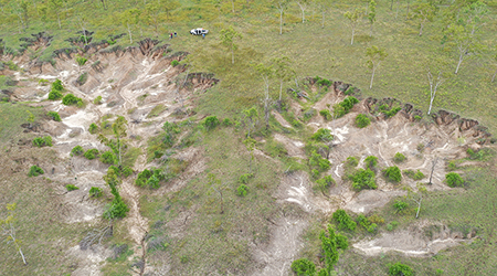
The Burdekin River delivers the highest volume of fine sediment of any river into the Great Barrier Reef lagoon. Greening Australia worked with a range of partners to remediate 10 alluvial gullies on Kirknie Station on the banks of the Bogie and Burdekin rivers, preventing 2,078 tonnes of fine sediment from reaching the reef annually.
Reef Check Australia
Townsville City Council
Australian Wildlife Conservancy
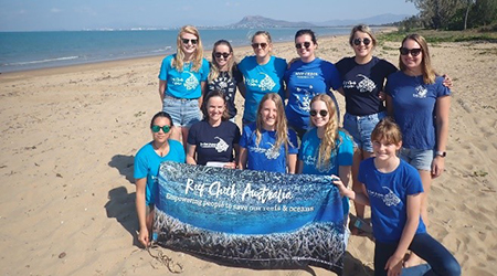
Since 2003, Reef Check Australia volunteers have been collecting locally and globally relevant reef health data as a part of a long-term monitoring program within the Townsville region.
 Funded through the Queensland Government’s Reef Assist program, Townsville City Council partnered with First Nations people and local businesses to deliver a range of activities including restoring riparian vegetation, removing flood debris, removing weeds and improving soil health.
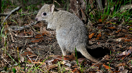 Australian Wildlife Conservancy has been working to create conditions for the return of the extremely rare northern bettong to a section of wet sclerophyll forest located north west of Townsville. Activities included removing cattle, prescribed burning, and manually removing woody weeds.
NQ Wildlife Care
OzFish Unlimited
MINCA
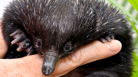 Voluntary non-profit group North Queensland Wildlife Care rescues sick, injured, and orphaned native wildlife until they are rehabilitated and can be released back into the wild. These include bandicoots, bettongs, snakes, turtles, and wallabies. A network of volunteers, in Townsville, Ingham, the Burdekin, Charters Towers and Mount Isa, cares for 2000-3000 animals each year in their own homes, successfully rehabilitating about half them.
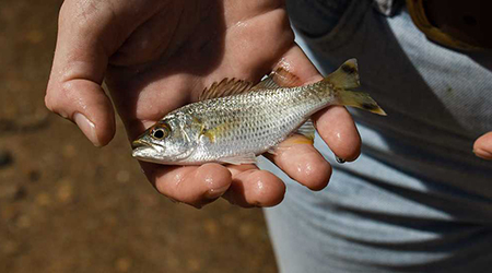 Fishing conservation charity OzFish Unlimited has been delivering the Creekwatch program in Townsville since 2021. The community awareness and citizen science program, established by Townsville City Council, encourages community members to participate in monitoring the condition of local waterways. By doing so, locals grow their knowledge and capacity, and help fill data gaps in regional waterway health.
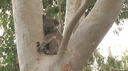 Bolger Bay contains the most extensive and continuous remaining area of lowland ecosystems on Magnetic Island, off the coast of Townsville. Environmental group Magnetic Island Nature Care Inc (MINCA) has been working to protect this important koala habitat, and, supported by the local community, raised more than $300,000 to purchase a key block of land so it could be maintained and protected.
Cultural burning
MICDA
Burdekin Irrigation Project
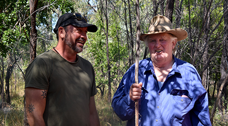 NQ Dry Tropics’ Cultural Fire Management for Grazing Landscapes project aims to revitalise ancient cultural fire management practices among Traditional Owners, while strengthening their relationships with graziers as they work together to heal Country.
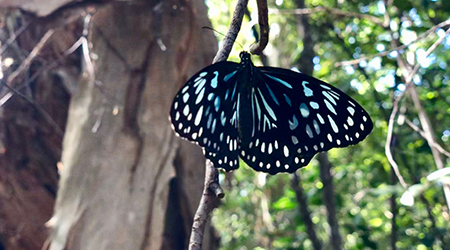 Magnetic Island Community Development Association (MICDA) developed a Community Action Plan mapping out partnerships and activities to achieve positive outcomes for the Great Barrier Reef and the population of Magnetic Island (Yunbenun).
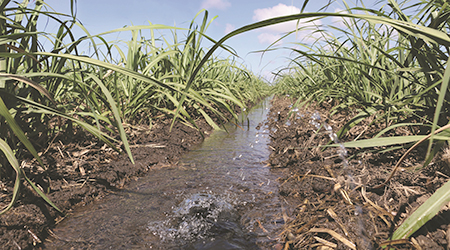
In the Burdekin, high yielding sugarcane results from high solar radiation and a reliable irrigation supply. Due to run-off from furrow irrigation systems, the region has been identified as a priority catchment for nitrogen and pesticide loads entering the Great Barrier Reef lagoon. The Burdekin Irrigation Project supports growers’ transition to more efficient irrigation reducing on-farm expenses, run–off and deep drainage losses while improving profitability and environmental outcomes.
Acknowledgements
| Bronwyn Bignoux | Townsville City Council |
| Terri Buono | Department of Agriculture & Fisheries (QDAF) |
| Dr Greg Calvert | Environmental Scientist and Consultant |
| Dr Niall Connolly | Department of Agriculture & Fisheries (QDAF) |
| Kate Cumming | Department of Resources |
| Paul Groves | Great Barrier Reef Marine Park Authority |
| Richard Hoolihan | Traditional Owner Management Group (Gugu Badhun) |
| Katie Malouf | AgForce Queensland |
| Allan McManus | Department of Defence |
| Jane Moore | Rivercea Pty Ltd |
| Natasha Rodwell | Coastal Dry Tropics Landcare Inc. |
| Trevor Robinson | Traditional Owner Management Group (Bidjara) |
| David Sartori | Lower Burdekin Water |
| Dr Samantha Stone-Jovicich | CSIRO |
| Jane Waterhouse | C2O Consulting & TropWater |
| Greg Watson | Canegrowers Burdekin |
| Dale Williams | Euri Gold Farms |
| Dr Yvette Williams | Reef and Rainforest Research Centre |
Assistance with this Status Report
Arcadia Coastcare; Australian Wildlife Conservancy; Barcaldine Regional Council; BBIFMAC Inc; Birdlife Townsville; Burdekin Shire Council; CANEGROWERS Burdekin Ltd; Coastal Dry Tropics Landcare Inc.; Greening Australia; Lower Burdekin Landcare; Magnetic Island Community Development Association; Magnetic Island Nature Care Assn Inc; North Queensland Conservation Council Inc.; North Queensland Wildlife Care Incorporated; OzFish Unlimited; Reef Check Australia; Sugar Research Australia; Sunwater; Tangaroa Blue Foundation; Townsville City Council; and Whitsundays Regional Council.
Statistics
| Burdekin Dry Tropics Region data | |
| Indicator | Where data obtained |
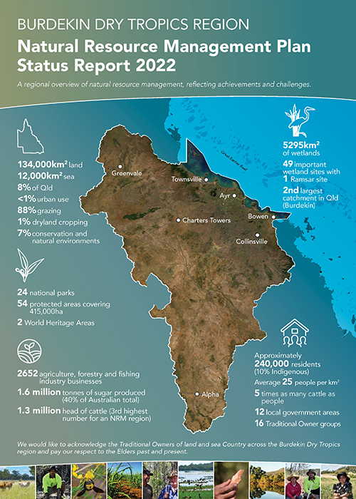
| Land area: 134,000km2 | https://nrm.nqdrytropics.com.au/ |
| Sea area: 12,000km2 | https://nrm.nqdrytropics.com.au/ |
| 8% of the area of Queensland | https://nrm.nqdrytropics.com.au/ |
| 12 Local Government Areas | https://nrm.nqdrytropics.com.au/ |
| Burdekin River catchment 2nd largest in QLD | https://nrm.nqdrytropics.com.au/ |
| 5,295km2 of wetlands with 49 important wetland sites, including 1 Ramsar listed wetland | https://wetlandinfo.des.qld.gov.au/wetlands/facts-maps/nrm-nq-dry-tropics/ and Australian Bureau of Statistics https://www.abs.gov.au/ausstats/abs@.nsf/Lookup/4609.0.55.001main+features52011 |
| 88% of land used for grazing, 7% for conservation and natural environments, 1% dryland cropping. Less than 1% urban land use | 2020 Reef report card
https://www.reefplan.qld.gov.au/tracking-progress/reef-report-card/2020 |
| 2,652 Agriculture, forestry and fishing industry businesses | Australian Bureau of Statistics – Data by region 2011-2022, by ASGS main structure (ASGS Ed. 3, 2021) Townsville & Charters Towers – Ayr – Ingham data |
| 2 World Heritage Areas | https://nrm.nqdrytropics.com.au/ |
| 54 protected areas, including 24 National Parks partly or wholly in the region covering an area of over 415,000ha | Qspatial https://qldspatial.information.qld.gov.au/catalogue/custom/viewMetadataDetails.page?uuid=%7B07E360E3-A191-4C24-9671-1471362F0B1B%7D |
| 16 Traditional Owner Groups | https://nrm.nqdrytropics.com.au/ |
| Indigenous Australians making up around 10% of the population | Australian Bureau of Statistics – Data by region 2011-2022, by ASGS main structure (ASGS Ed. 3, 2021) Townsville & Charters Towers – Ayr – Ingham data |
| Around 240,000 residents | Australian Bureau of Statistics – Data by region 2011-2022, by ASGS main structure (ASGS Ed. 3, 2021) Townsville & Charters Towers – Ayr – Ingham data |
| Around 25 people per square km (most concentrated in urban areas) | Australian Bureau of Statistics – Data by region 2011-2022, by ASGS main structure (ASGS Ed. 3, 2021) Townsville & Charters Towers – Ayr – Ingham data |
| Over 1.6 million tonnes of sugar produced (40% of total Australian production) | 2021 figures for Herbert-Burdekin region
https://asmc.com.au/policy-advocacy/sugar-industry-overview/statistics/ |
| Over 1.3 million head of cattle, the third largest cattle herd in Australia | 2019 data
https://www.mla.com.au/globalassets/mla-corporate/prices–markets/documents/trends–analysis/fast-facts–maps/2020/mla-cattle-numbers-map-2020-at-june-2019.pdf |
| 5 times as many cattle as people | Calculated from head of cattle and residents data |
| Caring for Country | |
| Indicator | Where data obtained |
| 1 Indigenous Protected Area | https://www.niaa.gov.au/indigenous-affairs/environment/indigenous-protected-areas-ipas |
| Over 4 million ha with Native Title finalised (nearly 30% of region) | Queensland Spatial Catalogue – https://qldspatial.information.qld.gov.au/catalogue/custom/index.page |
| 4 State and Commonwealth funded ranger programs | https://www.girringun.com/girringunrangers, https://gudjudatours.com/, https://parks.des.qld.gov.au/parks/magnetic-island/about#management, https://www.qld.gov.au/environment/plants-animals/conservation/community/land-sea-rangers/locations/palm-islands |
| 7 Indigenous Corporations undertaking Natural Resource Management work | https://nrm.nqdrytropics.com.au/community-consultation/ |
| 1 Cultural burning project | NQ Dry Tropics & WWF joint project |
| Working together | |
| Indicator | Where data obtained |
| Over 80 different organisations and government departments across 12 sectors involved in natural resource management in the region | https://nrm.nqdrytropics.com.au/community-consultation/ |
| 44 Reef Guardian Schools | https://www.reefed.edu.au/reef-guardian-school-portal |
| Over 2,500 people volunteered for NRM projects and activities in 2022 | Survey undertaken with NRM organisations in the region (total of 20 organisations responded) |
| Each organisation relies on an average of 10 partnerships across areas including industry, research, conservation and government to deliver NRM projects and activities – 80% of organisations partner with regional NRM organisations | Survey undertaken with NRM organisations in the region (total of 20 organisations responded) |
| Looking after our landscapes | |
| Indicator | Where data obtained |
| 7 Critically Endangered species, 23 Endangered species and 47 Vulnerable species | https://nrm.nqdrytropics.com.au/five-year-outcome-2/ |
| 9 Threatened Ecological Communities | https://nrm.nqdrytropics.com.au/addendum_1/ |
| 244ha of natural wetlands lost | 2020 Reef Report Card
https://www.reefplan.qld.gov.au/tracking-progress/reef-report-card/2020 |
| 56% of grazing land with adequate ground cover | 2020 Reef Report Card
https://www.reefplan.qld.gov.au/tracking-progress/reef-report-card/2020 |
| 3:1 the ratio of woody vegetation cleared: regrown | SLATS data 2019-2020 https://www.qld.gov.au/environment/land/management/mapping/statewide-monitoring/slats |
| 7,296 ha of riparian extent lost | 2020 Reef Report Card
https://www.reefplan.qld.gov.au/tracking-progress/reef-report-card/2020 |
| 280 weed species recorded in the region, 18 of National Significance | G. Calvert – personal communication & Atlas of Living Australia https://lists.ala.org.au/speciesListItem/list/dr823 |
| 11 Restricted invasive animal species found in the region, including 8 mammals, two fish and one insect species | https://www.business.qld.gov.au/industries/farms-fishing-forestry/agriculture/biosecurity/animals/invasive/restricted and Atlas of Living Australia occurrence records https://biocache.ala.org.au/#tab_simpleSearch |
| 8 Councils participating in the Regional Pest Management Group | https://www.nqdrytropics.com.au/projects/protecting-biodiversity/regional-pest-management-strategy/ |
| More than 734,500 ha of feral animal control undertaken by Councils in the region | Data supplied by councils. Note data is incomplete and not all councils data is included |
| More than 335,000 ha of weed control undertaken by Councils in the region | Data supplied by councils. Note data is incomplete and not all councils data is included |
| IUCN World Heritage outlook for the Great Barrier Reef World Heritage is Critical, Wet Tropics is Significant Concern | https://worldheritageoutlook.iucn.org/explore-sites |
| Effectively managing our resources | |
| Indicator | Where data obtained |
| Over $9 million invested in carbon projects through the Land Restoration Fund | https://www.qld.gov.au/environment/climate/climate-change/land-restoration-fund |
| Over $15 million invested in natural resource management in 2021-2022 by State and Federal Governments | https://www.nqdrytropics.com.au/wp-content/uploads/2022/10/NQDT-Year-in-review-2021-22.pdf |
| Over 26,000ha of sugarcane management practice improvements | 2020 Reef Report Card
https://www.reefplan.qld.gov.au/tracking-progress/reef-report-card/2020 |
| Over 450,000ha of improved grazing and gully management | 2020 Reef Report Card
https://www.reefplan.qld.gov.au/tracking-progress/reef-report-card/2020 |
| Over 6,500 tonnes sediment saved from reaching the reef | 2020 Reef Report Card
https://www.reefplan.qld.gov.au/tracking-progress/reef-report-card/2020 |
| Adapting for the future | |
| Indicator | Where data obtained |
| 4,220 small scale solar system installations | Australian Bureau of Statistics – Data by region 2011-2022, by ASGS main structure (ASGS Ed. 3, 2021) Townsville & Charters Towers – Ayr – Ingham data |
| 9 solar power farms, 12 proposed | https://electricity-generation-map.epw.qld.gov.au/ |
| 4 bioenergy power plants | https://electricity-generation-map.epw.qld.gov.au/ |
| 0 active coal-fired power plants | https://electricity-generation-map.epw.qld.gov.au/ |