
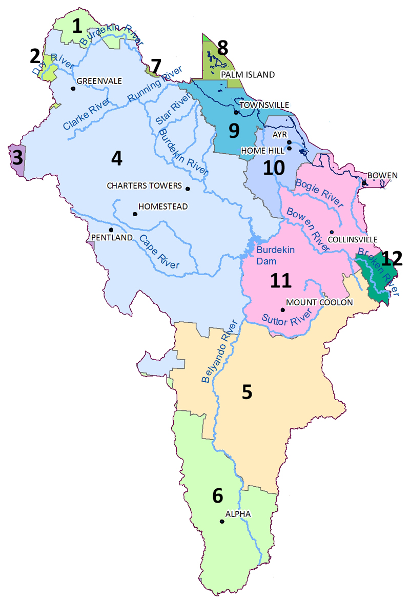
1 – Tablelands Regional Council
2 – Etheridge Shire
3 – Flinders Shire
4 – Charters Towers Regional Council
5 – Isaac Regional Council
6 – Barcaldine Regional Council
7 – Hinchinbrook Shire
8 – Palm Island Aboriginal Shire
9 – Townsville City
10 – Burdekin Shire
11 – Whitsunday Regional Council
12 – Mackay Regional Council
All levels of government are important partners in NRM in the region.
The region covers 12 local government areas, including Townsville, Burdekin, Charters Towers and Palm Island, significant parts of Whitsunday, Isaac and Barcaldine and small sections of the Tablelands, Etheridge, Flinders, Hinchinbrook and Mackay (see Figure 2).
Local government is actively involved in NRM, including through statutory town planning, strategic environmental management planning, public education, regulating development, and managing open spaces, which includes controlling weeds and other pests. Specific examples in the region include managing wetlands, beaches and foreshores in Townsville, Burdekin and Bowen, and Townsville City Council’s community energy programmes (wind, solar and reflective roofing).
The Queensland Government is actively involved in natural resource planning, management and regulation, including funding NRM programmes, managing state lands (including protected areas), allocating natural resources (water, minerals, quarrying), providing extension and education programmes, and regulating the use of, and impacts on, natural resources (such as vegetation clearing and mining). One of its important roles is to provide up-to-date information and maps on natural resources, for example, regional ecosystems and soils, which form the basis for informed NRM planning and management decisions.
The Australian Government provides national strategic direction through national plans such as the Reef 2050 Plan, oversees a threatened species programme, and World Heritage and other international agreements. It is a large investor in research and NRM activities, including funding universities, the Green Army, the National Landcare Programme, the 20 Million Trees Programme and projects to tackle invasive species.
The health of the GBR World Heritage Area is a major driver for funding NRM management in our region. The GBR Intergovernmental Agreement 2015 between the Australian and Queensland Governments reflects their shared responsibility for meeting the targets of the Reef 2050 Plan, which includes improving the quality of water leaving catchments that feed into the GBR. The Great Barrier Reef Water Science Taskforce identified that climate change is the most significant long-term threat to the GBR and improving water quality now will help build the GBR’s resilience and its ability to bounce back. The Taskforce identified that the greatest water quality risks to the reef are excess nutrients, fine sediments and pesticides (Great Barrier Reef Water Science Taskforce, and the Office of the Great Barrier Reef and Department of Environment and Heritage Protection , 2015).
Australian and Queensland governments’ investment makes it possible and achievable to understand natural resource values and threats, and to undertake innovative practices that lead to better management. However, it is critical that governments have strong connections with the region’s community so that they are aware of regional priorities when making NRM policies and decisions. Our community has identified that the shifts in policy direction caused by changes in government, remain a barrier to long-term sustainable NRM. Changes to government priorities can lead to funding cuts that impact upon worthwhile projects, and result in a loss of valuable scientific and technical research and information.
Related information
- 10 state electoral areas are fully or partially located in the Burdekin Dry Tropics region:
- Search for a current member of Queensland Parliament.
- 6 federal electoral areas are fully or partially located in the Burdekin Dry Tropics region:
- Search for a current member of the Australian Federal Parliament.