
Soil, biodiversity and vegetation on-farm services

Five-Year Outcome: By 2023 there will be an increased awareness and adoption of land management practices that improve and protect the condition of the soil, biodiversity and vegetation.
Investment Priorities:
Background:
The health and integrity of soils is recognised as pivotal for the productivity and resilience of agricultural landscapes. Degradation of soils through erosion, acidification and loss of carbon not only impacts productivity but has flow on effects, such as increased amounts of sediment in waterways, many of which are catchments for the Great Barrier Reef.
Vegetation has a vital role to play in maintaining soil health and agricultural productivity, with ground cover and the availability of the ‘3P’ grass species (perennial, palatable and preferred/productive) two areas of intense focus. However, vegetation has a larger role to play in maintaining the health and productivity of agricultural land, including providing shelter for livestock, stabilisation of streambanks, providing habitat for native species and influencing hydrological cycles. Maintenance and restoration of native vegetation has become an increasing focus of increasing the health and resilience of agricultural landscapes.
It is also increasingly being realised that biodiversity has an essential role to play in the health and resilience of agricultural land. Biodiversity is responsible for the balance of an ecosystem that enables it to retain its functionality, the provision of important species such as pollinators and as a source of genetic diversity, which is essential for resilience.
In the Burdekin Dry Tropics region grazing is the major land use (around 88 per cent), while intensive agriculture (mainly irrigated cropping) occupies around 1 per cent of the total region in coastal zones, including sugar cane production and horticultural production. The seasonality of the region (wet, monsoonal summers and dry winters) strongly affects water availability, water movement, vegetation growth and fire risk. The region is also subject to periods of drought (particularly in the western regions), flooding from monsoonal rains and cyclones.
Some of the major challenges in the region include retaining groundcover throughout the dry season, retaining natural pasture diversity and condition, slowing movement of large volumes of water through the landscape, preventing erosion and soil loss and minimising the amount of sediment and nutrients entering local waterways.
 Alignment with Sub-regional aspirations and regional goals:
These priorities align with the sub-regional and regional goals outlined in the NRM Plan:
- Burdekin rangelands sub-region: Sustainable land use – Our community would like to protect our land, which is a source of cultural identity and an inspiration for current and potential new enterprises, including tourism. We will continue to support property management, which integrates actions to look after soils, water, vegetation, weeds and feral animals, with agricultural best practice and business sustainability. We will strive to achieve good soil biodiversity, which benefits pasture, captures moisture and carbon, and prevents erosion (Page 14)
- Townsville Coastal Plains and Offshore sub-region: Catchment to reef water management – Our community sees water as the most valuable natural asset and we need to take a holistic view on how it is managed to protect the quality of water entering the GBR. Working with stakeholders across our region and with our neighbours, we will strive to collaboratively manage our waterways for low impact use, and diligently control sediments, nutrients and pest aquatic species. (Page 16).
- Lower Burdekin and offshore sub-region: Effective management of water and energy for productivity and the environment – Our community recognises the link between adopting innovation and profitability, and that efficient use of energy and water increases agricultural productivity and environmental protection. We will achieve this by sharing information, adopting beneficial technologies and clearly measuring results to build community resilience, successful enterprises, and the health of our local groundwater systems, rivers, wetlands and the GBR. (Page 18).Recognised land stewardship and control of introduced pests – Our farmers are stewards of the land, who seek to achieve social, economic and environmental outcomes for their enterprises to create security for their families and the community. Our community will encourage them to increase their uptake of best management practices and explore opportunities for financial incentives to reward sustainable practices. We will encourage urban development without the loss of prime farm land, and promote the importance of urban, rural and peri-urban residents proactively working together to tackle pest and weed issues. We would like to foster strategic and compatible land use to realise its full potential, while maintaining soil health and reducing unnecessary financial inputs (page 18)
- Bowen catchments and offshore sub-region: Soils for productivity – Our land and soils are interdependent and their health is critical for viable horticultural and livestock operations. We will undertake integrated land management practices to increase soil productivity and minimise sediment loads in local waterways, which can impact on fishing and tourism activities (Page 20).
- Belyando–Suttor sub-region: Good water and pasture – Our community’s biggest concern is water quantity and quality, for livestock, for our environment to be sustainable, and community survival. We will support best practices in water management in our region to assist grazing productivity, minimise the loss of soils, improve reef health and secure community infrastructure in an integrated manner. (Page 22).
This outcome aligns with the regional goal in the NRM Plan:
- Landscapes and soils are healthy (page 43).
The right to protect Country and culture is fundamental to Traditional Owners as the custodians of Country based on a history of more than 60,000 years. Traditional Owners aspire to have greater management, involvement and empowerment over Country and their cultural knowledge and understanding of Country are embraced. The Traditional Owner aspirations for the region can be found in the Burdekin Dry Tropics NRM Plan (pages 25-26), Caring for Country Plan (2005) and the Indigenous Participation Plan. Access to Country to connect and manage cultural and natural resources continue to be priorities for Traditional Owners. A map of Traditional Owner group areas can be accessed here.
Current Projects:
There are no current projects in the Burdekin Dry Tropics region addressing this outcome (however, see Current Projects for Outcome 6).
In addition to funding projects to address the five year outcomes and investment priorities, the National Landcare Program also funds Regional Agricultural Landcare Facilitators (RALFs) through each of the regional NRM bodies. The RALFs work within each region to support farmers, industry and community groups, including Landcare groups, to adopt new and innovative sustainable agriculture practices. Services provided by the RALFs include keeping farming communities up to date with new and innovative practices and government policies, facilitating partnerships between relevant groups such as industry and community, assisting farmers to develop new projects and secure funding and liaising with the Department of Agriculture, Water and Environment regarding local issues and events affecting farmers, industry and communities, such as natural disasters.
Key Collaborators:
This list does not cover all groups or organisations, but rather represents the ‘key’ organisations and groups whose assistance, advice, approval or cooperation would be required to work on hillslope erosion in the Burdekin Dry Tropics region:
- Department of Agriculture, Water and Environment (DAWE).
- Queensland Department of Agriculture and Fisheries (DAF).
- Landholder / managers (for work on privately held properties).
- Traditional Owner groups (see map).
- Agronomy Service Providers.
- CSIRO.
- NQ Dry Tropics.
Links and further information:
- Burdekin NRM Unit – Land Use Summary app – https://qgsp.maps.arcgis.com/apps/MapSeries/index.html?appid=457cf35ff6cc4f1ab260a961e4a5db91.
Hillslope Erosion
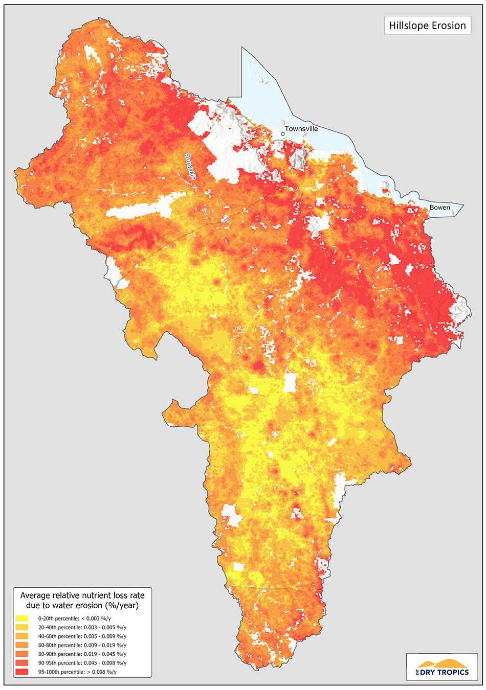
Hillslope erosion is the process by which soil is lost from sloping landscape surfaces (i.e. a hill). On hillslopes, the combined forces of water and gravity combine to erode the surface soil and carry it to lower areas in the landscape, often a waterway such as a creek or stream.
If the rate of soil loss from the hillslope is greater than that of the formation rate, there will be an overall loss of soil from the hillslope that cannot be replaced, reducing soil depth, condition and productivity. The soil eroded by water is usually carried by that water until it is deposited, either in a flat area of the landscape, or into a local water stream, affecting water quality.
The slope of the hill, the amount of water movement and the amount of vegetation on the hillslope all play a role in determining the rate and severity of hillslope erosion.
In the Burdekin Dry Tropics region, there is a substantial area considered to be at medium to high risk of hillslope erosion and it is considered to be one of the highest erosion areas in Australia. The majority of this area is used for grazing, therefore focussing on grazing management practices that retain hillslope vegetation and reduce erosion are critical strategies for managing and minimising hillslope erosion.

Monitoring:
There are currently no specific monitoring programs underway for hillslope erosion in the Burdekin Dry Tropics region, however the Paddock to Reef monitoring and modelling program does model rates of sediment loss, based on changed practices that affect groundcover and erosion levels. There is also information available through government sites with mapping and soil information.
Monitoring of late dry season ground cover and sediment and nutrients in waterways is part of the monitoring coordinated by Great Barrier Reef Marine Park Authority under the Reef 2050 Integrated Monitoring and Reporting Program (RIMReP). Results can be accessed through the knowledge system and Reef Report Cards.
- Paddock to Reef – https://www.reefplan.qld.gov.au/tracking-progress/paddock-to-reef
- Reef Knowledge System – https://reefiq.gbrmpa.gov.au/ReefKnowledgeSystem/About-the-program
- RIMReP – https://www.gbrmpa.gov.au/our-work/reef-strategies/reef-integrated-monitoring-and-reporting-program
- Reef Report Cards – https://www.reefplan.qld.gov.au/tracking-progress/reef-report-card
Potential indicators for hillslope erosion include:
- Percentage of ground cover (particularly during the dry season)
- Soil testing
- Water quality
- Land condition
Links and further information:
- Regional Land Partnerships app – https://erin.maps.arcgis.com/apps/MapSeries/index.html?appid=c2606f315ee74d899c4f7ae478c29ccc
- Queensland Government Publications Portal (reports on erosion and soils in the Burdekin region) – https://www.publications.qld.gov.au/dataset?q=burdekin
- Queensland Government soil data – https://www.qld.gov.au/environment/land/management/soil/soil-data
- CSIRO Report – Priorities for improving soil condition across Australia’s agricultural landscapes https://publications.csiro.au/rpr/download?pid=csiro:EP177962&dsid=DS3
- Queensland Government – Preventing and managing erosion – https://www.qld.gov.au/environment/land/management/soil/erosion/management
- CSIRO – Australian Soil Resource Information System – https://www.asris.csiro.au/index_ie.html
Soil acidification
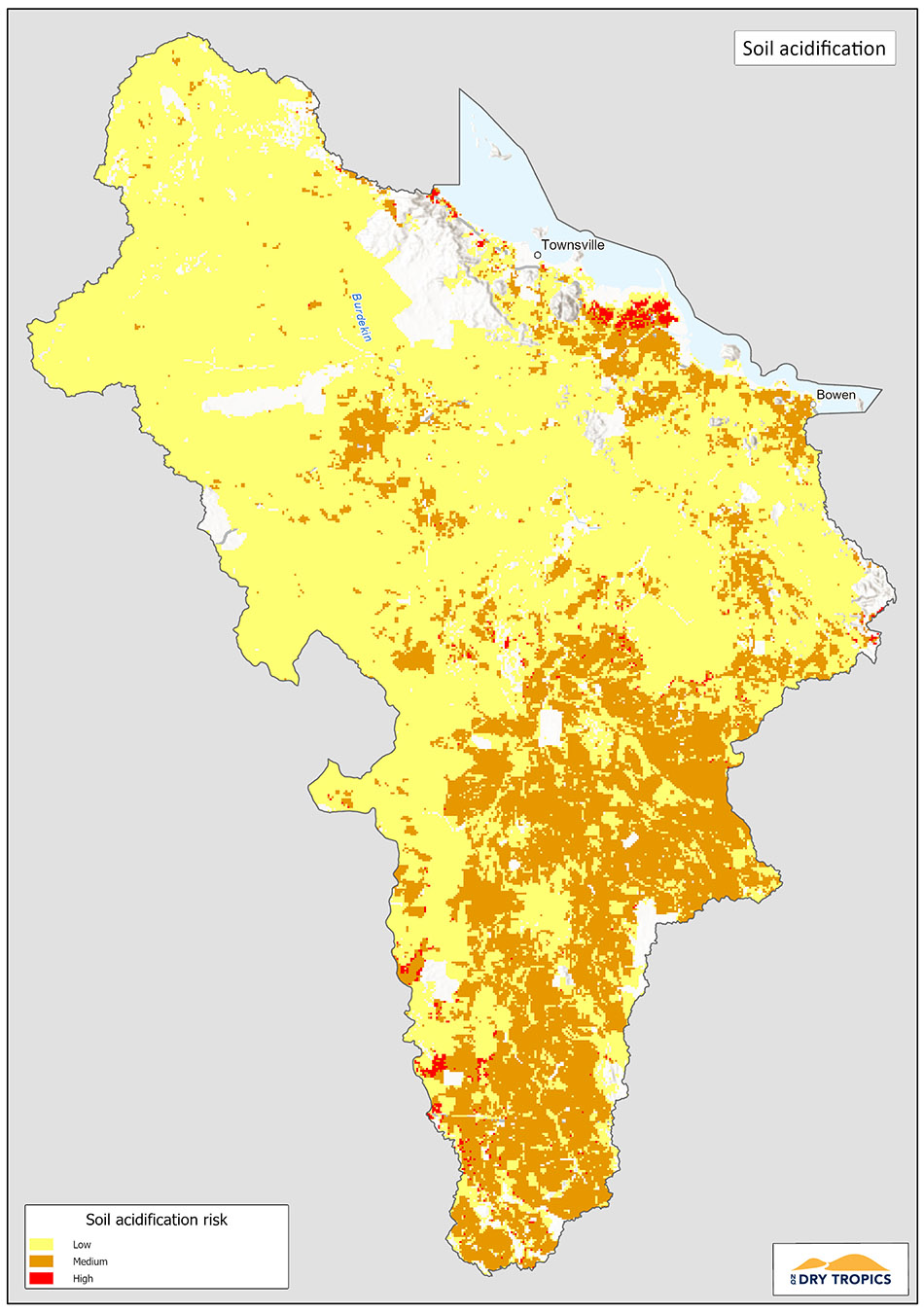
Soil pH is a fundamental quality of soils, affecting a wide range of attributes from microbial activity, ability to store carbon and vegetation composition and growth. Soil acidification occurs where the pH of the soil drops, making it acidic. It is a significant problem in Australia, affecting an estimated 50% of agriculturally productive soils.
Soil acidification can be caused by natural factors, such as high precipitation rates and substrate materials, and be accelerated by human activities, such as fertiliser application. Soils with a pH of 6.5 or below are considered to be acidic, with soils with a pH of 5.5 or below are considered strongly acidic.
The acidity of the soil can have a major impact on the condition of the soil and its ability to support vegetation. Soil acidity can cause major nutrients to either become toxic to plants, or make them unavailable to plants, both affecting plant growth and productivity. Increased soil acidity also negatively affects the ability of the soil to retain carbon.
In the Burdekin Dry Tropics region, there is a substantial area considered to be at medium risk of soil acidification (predominantly in the southern half of the region). Areas with high intensity agriculture are particularly at risk, as activities such as fertiliser application can accelerate acidification.
While the application of lime can reduce acidity, this is only cost effective on a relatively small scale and can only address soil acidity at the surface level, therefore prevention of acidification of the soil is preferred.

Monitoring:
There are currently no ongoing monitoring programs underway for soil acidity in the Burdekin Dry Tropics region, however soil testing and monitoring is undertaken routinely by landholders, agronomy and NRM service providers.
The indicator for soil acidity is the pH level of the soil. Historical measurements from the same site will show the rate at which acidification is occurring.
Links and further information:
- Regional Land Partnerships app – https://erin.maps.arcgis.com/apps/MapSeries/index.html?appid=c2606f315ee74d899c4f7ae478c29ccc
- Queensland Government Publications Portal (reports on soils in the Burdekin region) – https://www.publications.qld.gov.au/dataset?q=burdekin
- Queensland Government soil data – https://www.qld.gov.au/environment/land/management/soil/soil-data
- CSIRO Report – Priorities for improving soil condition across Australia’s agricultural landscapes https://publications.csiro.au/rpr/download?pid=csiro:EP177962&dsid=DS3
- CSIRO – Australian Soil Resource Information System – https://www.asris.csiro.au/index_ie.html
- Queensland Government – Soil acidification fact sheet – https://www.publications.qld.gov.au/dataset/science-notes-soils/resource/2a2b6fc7-671d-4031-96ad-377eaabba6fa
- Soil Quality – fact sheet – http://soilquality.org.au/factsheets/soil-acidity
- Geoscience Australia – Preliminary soil pH map of Australia http://www.ga.gov.au/webtemp/image_cache/GA16735.pdf
Soil carbon
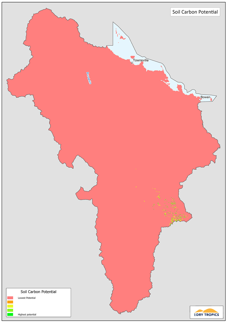
Soil has the ability to store, cycle and release carbon as part of the natural carbon cycle.
Carbon in soils occurs in two forms: inorganic and organic.
Inorganic carbon is mineral based e.g. calcium carbonate, whereas organic carbon comes from organic sources, such as decaying vegetation.
Managing soil carbon usually refers to managing the organic component of soil carbon, which can be influenced through activities such as clearing of vegetation, tilling of soil, crop rotation and residue handling, erosion and fertiliser use.
Increasing and maintaining soil carbon content has a number of benefits, including improving the condition and resilience of the soil, increased productivity and carbon sequestration.
The amount of soil carbon that can be captured and held by a soil depends on the capacity of the soil to hold carbon, the amount of carbon available to be added to the soil and the rate of loss of carbon to the atmosphere.
In the Burdekin Dry Tropics region, the loss of soil carbon and/or the ability to store more carbon is considered to be low for the majority of the region, compared to more southerly areas of the state. This is due to a range of factors, including soil type, history of vegetation clearing and type of agriculture practiced.
While the risk of carbon loss and capacity to increase soil carbon in the soils of the region is considered low, managing soils to maximise soil carbon is still beneficial for soil condition and productivity and plays a role in preventing erosion and acidification. Managing and increasing soil carbon is also a potential source of income through carbon credit trading schemes.

Monitoring:
Monitoring for soil carbon typically occurs at the property level by the landholder, however with the emergence of soil carbon as a potential income source, there is likely to be a rise in soil carbon monitoring using standardised techniques.
The National Soil Carbon Program outcomes for Queensland can be accessed at publications.qld.gov.au/dataset/soil-carbon-program
Measuring soil carbon normally requires laboratory testing, however work is being undertaken to improve the simplicity and affordability of soil carbon testing.
Links and further information:
- Regional Land Partnerships app – https://erin.maps.arcgis.com/apps/MapSeries/index.html?appid=c2606f315ee74d899c4f7ae478c29ccc
- Queensland Government Publications Portal (reports on soils in the Burdekin region) – https://www.publications.qld.gov.au/dataset?q=burdekin
- Queensland Government soil data – https://www.qld.gov.au/environment/land/management/soil/soil-data
- CSIRO Report – Priorities for improving soil condition across Australia’s agricultural landscapes https://publications.csiro.au/rpr/download?pid=csiro:EP177962&dsid=DS3
- CSIRO – Australian Soil Resource Information System – https://www.asris.csiro.au/index_ie.html
- Queensland Government – Carbon farming methods – https://www.qld.gov.au/environment/climate/climate-change/land-restoration-fund/about/carbon-farming-methods
- Department of Agriculture, Water & Environment – Soil carbon – https://www.agriculture.gov.au/ag-farm-food/climatechange/australias-farming-future/soil-carbon
Vegetation and biodiversity on farms
 Given that agriculture is the dominant land use in the region (nearly 90%), the majority of land and its associated vegetation and biodiversity is managed by agricultural land holders and managers.
Since European arrival, significant amounts of native vegetation have been cleared for development and agriculture. This has resulted in many species and ecological communities being reduced to a small fraction of their former range, making them vulnerable to extinction. Species of plants were often introduced, either as crops or as preferred grass species for grazing. Many of these species outcompete native species, further degrading native ecological communities. Additionally, unintentionally introduced species have become invasive and place additional stress on these natural communities (see Threatened Ecological Communities section of this Addendum).
Alongside this process is an associated loss of biodiversity. Biodiversity can be broadly described as the diversity of living organisms in an ecosystem. In this context, biodiversity typically refers to the diversity of native organisms. In a complete and functioning ecosystem, each organism has evolved in response to the environment and to the other organisms in that environment. Different organisms perform different ‘roles’ within the ecosystem, such as pollinating plants, breaking down and recycling organic materials, eating vegetation and predating on other animals. Through these interactions the ecosystem reaches a state of balance. When this ecosystem experiences a disturbance, either natural, such as a severe weather event or human-induced such as clearing vegetation, the network of organisms is disrupted and if the disturbance is sufficiently severe and/or continues the network is permanently altered, leading to impaired function of the ecosystem as a whole and loss of organisms, their roles and relationships. This can also lead to outbreaks of particular species in large numbers that would otherwise have been prevented.
Biodiversity is an important resource, not only for agriculture, but for the health of all people and other species on earth. Greater biodiversity, including diversity of genetics, enables species and ecosystems to absorb the impact of a disturbance and return to a state of equilibrium and provides the ability to change and adapt over time. Diversity of species enables the full range of roles to be played. In the agricultural context this is particularly important for species that provide services to agriculture, such as pollinators and animals that eat, or compete with, pest species.
As land holders and managers are responsible for managing a large proportion of land, both Australia wide and in the Burdekin Dry Tropics, there is a need for this land to be managed both as an agricultural resource and as an ecological resource for the benefit of the community.
While there can be tension between agricultural activities and preservation of ecological communities and species, increasingly the mutual benefits of farming for production and ecological health are being recognised.
In the Burdekin Dry Tropics region, work is being undertaken to preserve remnants of native vegetation, particularly those listed as threatened and improving the condition of these remnants. This includes vegetation that grows on the banks of watercourses and wetlands (riparian vegetation) which also plays an important role in water quality. This may include fencing areas of remnant vegetation to exclude feral animals and manage stock access, culling feral animals, treating invasive weed species, replanting native plant species, education and training and incentive schemes for the retention and improvement of native ecological communities.
Supporting native vegetation, species and ecological communities contributes to biodiversity by providing the environment in which biodiversity is supported and maintained.

Monitoring:
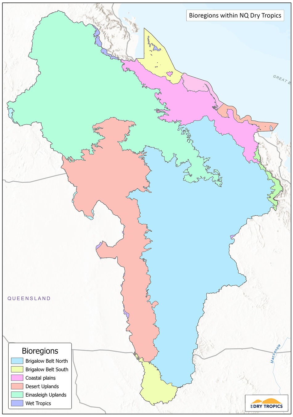
In Queensland regional ecosystems are classified according to the Regional Ecosystem Framework which assigns a number based on the bioregion, land type and vegetation. qld.gov.au/environment/plants-animals/plants/ecosystems/descriptions/framework
There are 13 bioregions in Queensland and the Burdekin Dry Tropics includes: Wet Tropics, Einasleigh Uplands and Brigalow Belt.
Monitoring occurs at a range of scales, from continent and state wide monitoring, such as the State of the Environment report https://www.stateoftheenvironment.des.qld.gov.au/home and the National Vegetation Information System – http://www.environment.gov.au/land/native-vegetation/national-vegetation-information-system down to the local scale by individual groups or land holders. Monitoring is also done for compliance checking and planning e.g. planned burns.
Monitoring for vegetation can be conducted from aerial (satellite, plane and drone imagery), through to on-ground surveys using a range of methods. For remnant vegetation important characteristics for monitoring include the size and shape of the remnant (small or narrow areas are most susceptible to impacts), the species present, the structure of the vegetation (the layers e.g. canopy, shrubs, grasses and how these are spread out) and the nature and magnitude of the threats (e.g. presence and abundance of weed species).
Monitoring for biodiversity can include a wide variety of techniques. Given the number of organisms that can be present in an ecosystem and the complex relationships between them, monitoring is often limited to a subset of the measurements that could be undertaken, for example the presence and abundance of key species (indicator species), presence and abundance of pest species, area of disturbed and undisturbed habitat, monitoring of particular guilds, e.g. nectivorous species or the total number of different species in a defined area.
Links and further information:
- Burdekin Dry Tropics Conservation Action Planning Summary Report.
- Regional Land Partnerships app – https://erin.maps.arcgis.com/apps/MapSeries/index.html?appid=c2606f315ee74d899c4f7ae478c29ccc
- Queensland Government Publications Portal (reports on soils in the Burdekin region) – https://www.publications.qld.gov.au/dataset?q=burdekin
- Queensland Government soil data – https://www.qld.gov.au/environment/land/management/soil/soil-data
- CSIRO Report – Priorities for improving soil condition across Australia’s agricultural landscapes https://publications.csiro.au/rpr/download?pid=csiro:EP177962&dsid=DS3
- CSIRO – Australian Soil Resource Information System – https://www.asris.csiro.au/index_ie.html
- Queensland Government – Carbon farming methods – https://www.qld.gov.au/environment/climate/climate-change/land-restoration-fund/about/carbon-farming-methods
- Department of Agriculture, Water & Environment – Soil carbon – https://www.agriculture.gov.au/ag-farm-food/climatechange/australias-farming-future/soil-carbon