All posts by Ted Bragg

Cultural burning

Healing Country with cultural fire

Second fire management workshop at Jervoise Station in June 2022. Victor Steffensen, Firesticks Alliance, and Greg Jonsson, grazier, Jervoise Station.

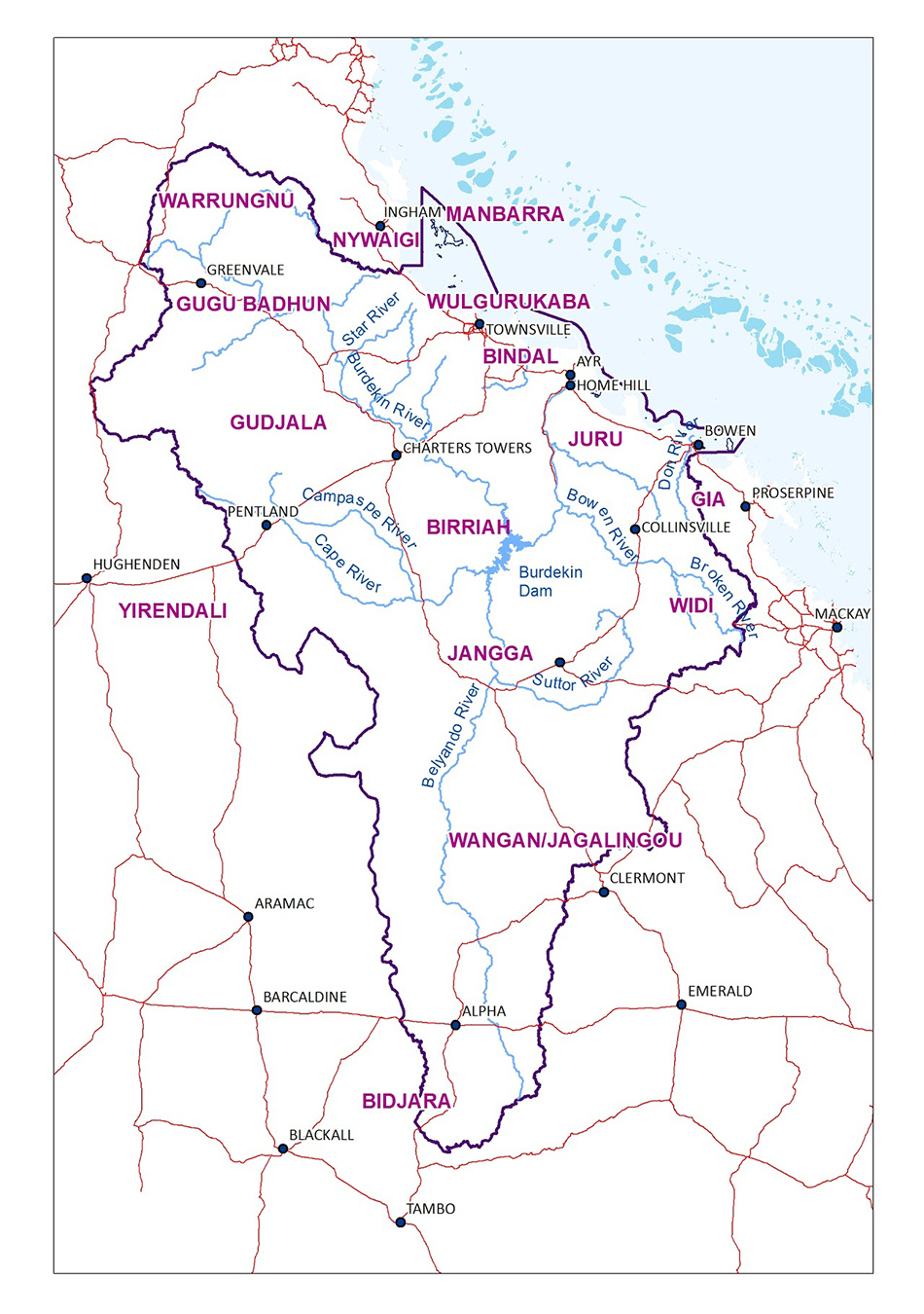
The Burdekin Dry Tropics Traditional Owner Management Group (TOMG), which consists of leaders from 14 Traditional Owner groups, has been providing advice and direction to NQ Dry Tropics for more than 20 years. 

In 2020 the TOMG identified a priority to build regional First Nations people’s capacity and capability to undertake cultural fire practices. As a result, NQ Dry Tropics worked closely with the TOMG to develop and design the Cultural Fire Management for Grazing Landscapes project. 

Delivered in partnership between Traditional Owners of the Burdekin Dry Tropics region, WWF-Australia, Firesticks Alliance, and graziers, the project’s main objective is to revitalise ancient cultural fire management practices among Traditional Owners, while strengthening their relationships with graziers as they work together to heal Country. The project, which employs a full time First Nations Cultural Fire Management Project Officer, aims to demonstrate how cultural fire can improve the health and productivity of grazing land, benefit biodiversity, and  greatly reduce the risk of wildfires.

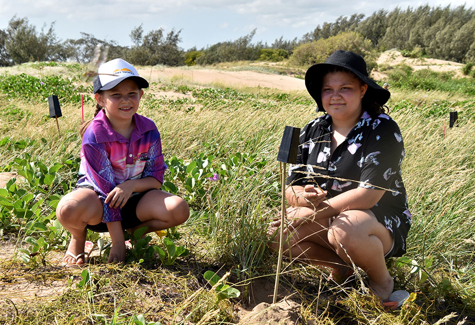
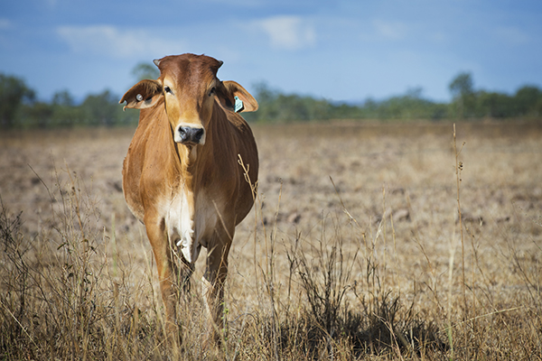
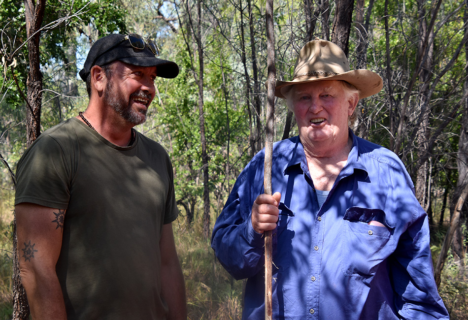
Organic cattle property Jervoise Station, on Gugu Badhun country near Greenvale, is operated by three generations of the Jonsson family. They were keen to get involved, and were chosen as a demonstration site for a carefully-planned two-year cultural fire management regime overseen by Gugu Badhun Traditional Owners and Firesticks Alliance Lead Fire Practitioner, Victor Steffensen. 

Pictured at the workshop are (from left) Josephine Smallwood (Wangan and Jagalingou), NQ Dry Tropics Partnerships Coordinator Karen Vidler, with graziers Ashton Reynolds and Elliot Smith.

Mr Steffensen said traditional knowledge and cultural fire management was needed back in the landscape to address environmental problems:

 “This is about connecting people back to Country and healing Country in a way that improves landscapes and livelihoods at the same time,” Mr Steffensen said.

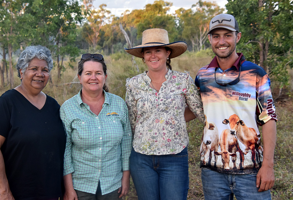
During a series of facilitated workshops and burns, Traditional Owners and grazing property owners learned more about reading Country, helping them to better understand landscape condition and determine how to restore balance through cultural burning.

Four workshops have been held so far on Gugu Badhun and Bindal country, all of which were well-attended, with 12 of the regions’ Traditional Owner groups represented from across the region including Traditional Owner Elders, Gudjuda Rangers, Girringun Rangers, Minggamingga Rangers, Wulgurukaba QPWS Rangers, Rural Fire Service, and Indigenous employment group Three Big Rivers.  

The “Cultural Fire Management for Grazing Landscapes” project is funded through WWF-Australia’s Indigenous Fire Management Program.

Workshop participants (from left) Reg Kerr (Gudjala), Richard Hoolihan (Gugu Badhun), Scott Crawford (CEO, NQ Dry Tropics), Ben Kitchener (Indigenous Fire Coordinator, WWF-Australia), Victor Steffensen (Firesticks Alliance Lead Fire Practitioner), Jervoise grazier Greg Jonsson with granddaughter Ashton Reynolds, and Josephine Smallwood (Wangan and Jagalingou).

Traditional Owner Management Group

Townsville City Council

Reef Assist makes waves in first phase

The Townsville City Council’s (TCC) Reef Assist – Business Activity and Environmental Restoration project was funded through the initial stage of the Queensland Government’s $33.5 million Reef Assist program.

It was proudly delivered by TCC, in collaboration with five business partners, including three First Nations and two not-for-profit local businesses.

During its first phase, spanning the whole of 2021, the project achieved a range of outcomes, including riparian vegetation restoration, foreshore restoration, bank stabilisation, flood debris removal, soil health remediation, weed removal and humification, and development of low-impact eco-trails.

The project also sought to enhance longer-term environmental outcomes for the region, building local skill and restoration capacity through employment, training, and creating opportunities for circular economy outcomes.

The engagement and upskilling of First Nations people as part of this project have provided the opportunity to connect to Country and deliver impactful management outcomes across key landscapes.

Training programs have amplified Townsville’s natural resource management industry and built the region’s capacity to undertake rehabilitation works into the future.

The project also provided a great opportunity to further develop the model for the reuse of weeds removed and harvested from riparian zones.

Previously, weeds removed were trucked to Waste Recycling Facilities, where materials could end up landfill at a cost. Now, harvested weeds can be generated into a stable and beneficial product for enhancing on-site soils.

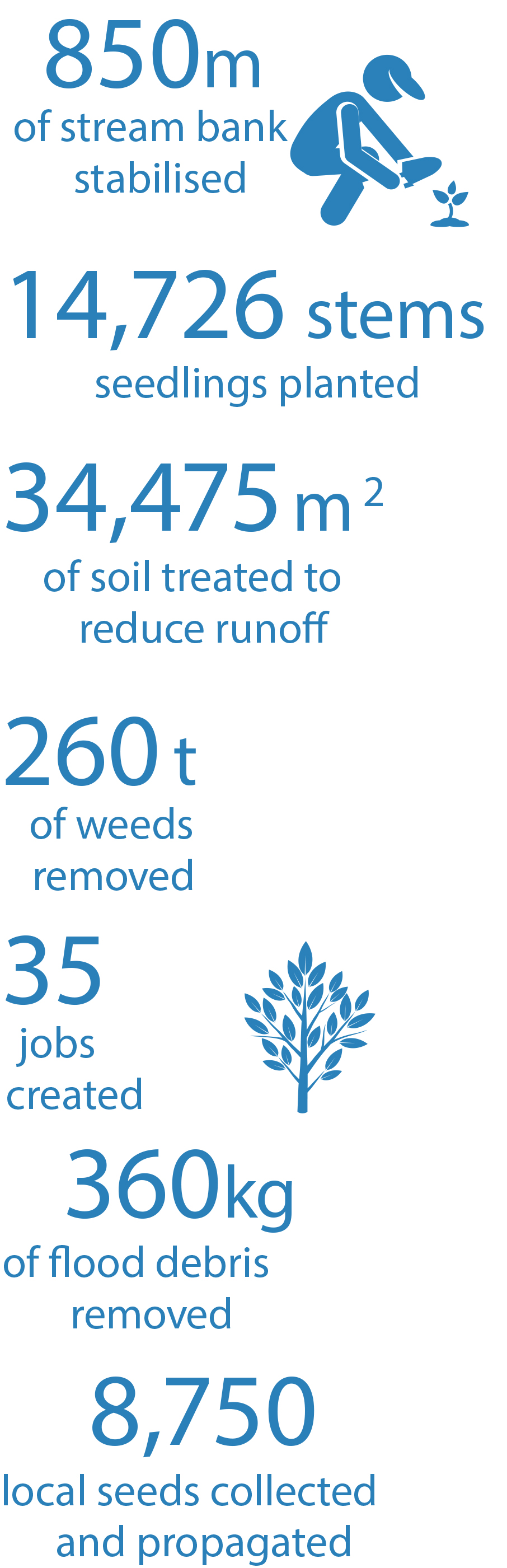
The Reef Assist project has continued throughout 2022, delivering continued beneficial outcomes for local waterways, including the construction of leaky weirs and other sediment erosion control structures, and thousands more local native tree plantings.

“Reef Assist has been great for Ausfield Services to build our staff skills and capability in the delivery of environmental restoration projects,” Sharon from Ausfield Services said.

“Working collaboratively with the Townsville City Council sustainability team, community stakeholders, Indigenous groups and other small businesses has led to profitable relationships and made us a stronger company with knowledgeable crews.”

Burdekin Shire Council – Alva Beach

Community partnerships protect coastal ecosystem

Lekyrah, (left), and Schanette Byers, Ayr.

Coastal ecosystems link land with water, and provide a variety of benefits to society, including carbon storage, commercial and recreational fisheries, migratory bird habitat, and flood mitigation

In the Burdekin region these ecosystems, which connect to the Great Barrier Reef World Heritage Area, face a range of threats, including weeds, feral animals, and human activity.

For example, the dune system at Lynch’s Beach, near Ayr, had become severely degraded by four-wheel drive vehicles and quad bikes, which had damaged the vegetation binding the dunes together, exposing the sand to wind erosion.

Burdekin Shire Council partnered with NQ Dry Tropics to install fencing and signage to help protect the seedlings and inform the public about the importance of keeping vehicles off the dunes. 

The two groups also organised a Community Planting Day, attended by 50 locals who planted 450 stems selected for their ability to withstand harsh coastal conditions, such as beach hibiscus, Burdekin plum and spinifex.

Burdekin Shire Council Mayor Lyn McLaughlin said the event was very well-attended by both residents and visitors to the region.

“I want to thank the community for supporting the Alva Community Planting Day, which is an important step in stabilising dunes on Lynch’s Beach and reducing further erosion and damage from four-wheel drives and quad bikes,” Cr McLaughlin said.

“Burdekin Shire Council’s Dune Management Strategy outlines the importance of dunal systems at both Alva and Wunjunga, with revegetation a key strategy to stabilise them and ensure their longevity – however this is only possible with the continued support of the community. 

“Please obey all signage and fencing in the area to give new vegetation the best chance of survival and to ensure we are not further damaging these dune systems to leave a strong legacy for future generations.”

Event organiser, NQ Dry Tropics Biodiversity Project Officer Brittany Butler, said the turnout reflected the importance of the beach not just for the lower Burdekin community, but also Townsville residents.

“We had plenty of participants from Alva and Ayr, but also others from as far afield as Bushland Beach,” Ms Butler said.

“I was pleased to see so many enthusiastic kids wanting to plant trees and learn how the dunes protect the coastline from erosion and storm inundation.

“Attendees represented groups including Lower Burdekin Landcare, Coastal Dry Tropics Landcare Inc, Gudjuda, Centrogen, Three Big Rivers, and the Invasive Species Council.

”Today’s endeavours are part of a wider revegetation effort organised by NQ Dry Tropics at Alva, where members of Lower Burdekin Landcare, Gudjuda Reference Group Aboriginal Corporation, and Three Big Rivers planted and maintained thousands of native plants on the dunes.”

Sarita and Keatan Jarvis, Ayr.

Keith Kiloh, Chair, Lower Burdekin Landcare, with Brittany Butler, Biodiversity Project Officer, NQ Dry Tropics.

Linda Govan, Coordinator, Environment and Health Projects Burdekin Shire Council with Dan Mulcahy, Manager Environmental and Health Services, Burdekin Shire Council.

Pictured at the planting day are (fromn left): Annalise and Rose Trigg (Bushland Beach) with Paige Colls (Ayr).

Cr Sue Perry, Deputy Mayor, Burdekin Shire Council.

Alva Community Planting Day, Lynch’s Beach.

Darryl Chong and Trevor Riley, of Three Big Rivers, watering the site post-event

Dawn at Lynch’s Beach. Photo: Grail Films

Arcadia Coastcare

Native plants booklet, a guide for island walkers


A booklet and self-guided walk to help locals and visitors explore Magnetic Island’s foreshores and reserves launched in late 2022.

The booklet covers more than 60 native plants in easily accessible locations at Arcadia and links many insects to their host plants.

The visually stunning publication ‘Some Native Plants of Arcadia, Magnetic Island (Yunbenun)’ was written by Arcadia Coastcare.

Co-author Selina Hale said many people contributed to the booklet.

“It reflects many voices and ways of expression and uniquely combines local, scientific and Indigenous knowledge,” she said.

Botanist Professor Betsy Jackes said if you had the booklet, then no walk would ever again be boring.

“Here is your chance to note how the plants and the 3Bs — birds, butterflies and bugs — all interact and are dependent on one another,” she said.

“I hope this booklet encourages you to take a slow stroll around Arcadia rather than a speedy walk or run.”

Butterfly expert Professor Peter Valentine said local nature havens were increasingly important as climate change impacted our environment and lifestyle.

“This excellent booklet is a wonderful asset for the people of Magnetic Island and Townsville to get to know the natural history in their backyard,” he said.

Lead author Selina Hale addresses the audience at the book launch.

Division 3 representative Cr Ann-Maree Greaney said Townsville City Council was proud to support the development of the booklet which provided an invaluable insight into the island’s natural environment.

“Townsville is lucky to be home to diverse flora and fauna and it’s our shared responsibility to protect our environment each and every day,” she said.

“I know this booklet will be greatly appreciated by locals and visitors.”

Arcadia Coastcare acknowledges the financial support of Townsville City Council and Magnetic Island Nature Care Association (MINCA). Proceeds from booklet sales will be used by MINCA to fund island conservation activities.

Arcadia Coastcare is a volunteer community group helping council and National Parks look after natural areas on public land at Arcadia through weed control, tree planting, habitat protection and knowledge sharing.

The booklet is for sale at Arcadia Newsagency, The Old Island Nursery, Magnetic Museum and Mary Who? Bookshop.

Pictured at the book launch are (from left): Selina Hale with co-presenters Dr Betsy Jackes and Cr Anne-Maree Greaney.

Reef Check Australia

Monitoring the inshore reef on Magnetic Island

Hard coral around Magnetic Island has reduced by 20 per cent.

Since 2003, Reef Check Australia volunteers have been collecting locally and globally relevant reef health data as a part of a long-term monitoring program within the Townsville region. Inshore reefs are extremely important environments, offering refuge and nursery for a variety of invertebrate and fish species.

Magnetic Island inshore reefs are resilient; despite being impacted directly from activities occurring on land. Around Magnetic Island alone, volunteers have donated 4,608 hours and collected 23,040 pieces of substrate data, along with data on invertebrates, impacts and fish.

Hard coral is one of the most important substrate categories we measure. Since our monitoring began, average hard coral coverage around Magnetic Island reduced progressively from 40 per cent in 2007 to 20 per cent in 2013/2014 however has been steadily increasing since then and currently sits around 44 per cent. The more robust foliose coral and encrusting corals (as pictured above) are the most frequently sighted. Reef Check Australia monitors several impacts to corals, with coral bleaching being the topic of most frequently asked questions.

Fortunately, coral bleaching around Magnetic Island was limited and generally affected less than 5% of the coral population during our recent surveys. Although an increase was detected in 2015/2016 during a significant bleaching event, the good news is the amount of coral bleaching detected reduced again in 2017 and has continued to remain low.

Reef Ambassador program

The Reef Check Australia team.

Recognising the gap between science, and communication, Reef Check launched the Townsville Reef Ambassador program in March 2017, and since then, its network of Reef Ambassadors has grown exponentially. They helped run the first Seaside Scavenge events for North Queensland, joined the plastic straw-free movement with the inspiring crew at The Last Straw on the Great Barrier Reef, and reached thousands of community members through events including market days, beach clean-ups, DIY beeswax wraps events, and sustainability days.

The Reef Ambassador program continues to grow, with new participants leading the way in reducing impacts on reefs and oceans through community engagement, education, and sharing success stories. Reef Check believes each individual plays a huge role in their community, and the group plans to continue facilitating hands-on courses to empower community members to make real differences in the world around them.

By partnering with organisations such as Townsville City Council, Reef Check is able to continue to develop its programs and train community leaders to communicate, engage and empower their peers.

MERI

Monitoring, evaluation, reporting and improvement

Natural resource management in the Burdekin Dry Tropics region involves a wide array of stakeholders and participants, as outlined in the Community consultation, engagement and collaboration section. Each organisation and group involved in natural resource management has its own reporting requirements and regulations. Some of these are formal and publicly accessible, while others are less formal in nature and not available to the general public.

For each of the Five-year Outcome sections in this Addendum, relevant monitoring programs and information is provided, along with a list of potential indicators for monitoring of that resources, system or species. The Conservation Action Plan also outlines monitoring requirements for each community or species addressed.

Below is a summary of the major monitoring that is undertaken in the region, where the monitoring program information is publicly available.

Great Barrier Reef Marine Park Authority Reef 2050 Integrated Monitoring and Reporting Program (RIMRep)https://www.gbrmpa.gov.au/our-work/reef-strategies/reef-integrated-monitoring-and-reporting-program

This monitoring is a large, coordinated effort between different stakeholders in the health, protection and use of the Great Barrier Reef. The monitoring provides information for the GBRMPA Reef Knowledge System, Reef Report Cards and other reports. Information covered includes water quality (sediment, nutrients, pesticides), groundcover levels and inshore marine condition, including seagrass and coral. Reports are available for NRM regions and catchments.

Paddock to Reefhttps://www.reefplan.qld.gov.au/tracking-progress/paddock-to-reef

Reef water quality monitoring and reporting is also informed through the Paddock to Reef program, which is a large-scale monitoring and modelling program that evaluates management practice adoption and effectiveness, catchment condition, pollution run-off and marine condition. These areas are inter-linked and integrated through a common assessment and reporting framework.

Dry Tropics Partnership for Healthy Waters https://drytropicshealthywaters.org/ and Healthy Rivers to Reef Partnerships – https://healthyriverstoreef.org.au

These collaborations are between community, industry, science, research and government to provide catchment-level annual report cards on the ecological, social and economic health of the GBR and waterways in the Townsville Dry Tropics region.

Queensland State of the Environment Reporting – https://www.stateoftheenvironment.des.qld.gov.au/

This state-wide reporting assesses the state and condition of Queensland’s environmental assets and the pressures affecting these.

Statewide Landcover and Trees Study (SLATS)

https://www.qld.gov.au/environment/land/management/mapping/statewide-monitoring/slats

SLATS is a scientific monitoring program led by the Queensland Department of Environment and Science’s in conjunction with other organisations to capture satellite imagery and field data that enables annual reporting of changes in woody vegetation. This includes data for legislative purposes and data is used to inform natural resource planning, management and reporting.

Regional Report Card

In addition to the above, a Regional NRM Plan Report Card is planned that will provide a broad overview of natural resource management in the region under several themes: Working together; Adapting for the future; Looking after our landscapes; and Effectively managing our resources.

The report card will include three sections:  ‘Region at a glance’ that provides context e.g. major land use; population and production figures; Indicators (listed below) that will provide information on trends in natural resource use and management and case studies that highlight particular issues or achievements in NRM in the region.

Information will be drawn from existing monitoring and reporting programs and with the assistance of regional organisations and groups.

Potential Indicators for Report Card:

Theme Indicator
Adapting for the future Number of renewable and bioeconomy energy projects or investments in the region
Number of councils with climate change plans
Use of renewable energy (as a % of total)
Number of NRM research projects in the region
Training and education opportunities (and no. of attendees)
Number of schools with NRM related programs or activities
Effectively managing our resources Hectares with improved practice
Progress towards water quality improvement targets
Number of land holders with best management practice
Amount of groundcover
Sugarcane production
Beef production
Looking after our landscapes Amount of native vegetation cleared / replaced
Pest plant and animal information / biosecurity threats
$ invested in NRM projects in the region
Freshwater connectivity
Trends in threatened species status (vulnerable, endangered, etc)
Working together Partnerships in NRM delivery
Number of landholders involved in NRM projects
Traditional Owner participation
Volunteer time


COMMUNITY CONSULTATION

Community consultation, engagement and collaboration

Community collaboration is essential for the planning, implementation and evaluation of natural resource projects and activities in the Burdekin Dry Tropics region. Consultation, engagement and collaboration takes place at all levels, from small regional groups and individual landholders, through to state and commonwealth government departments. Consultation, engagement and collaboration also take place in formal and informal ways, with differing levels dependent on the nature, location and focus of the project or activity. All natural resource management projects and activities rely on the collaboration between different stakeholders and community members.

As part of the activities for the current Regional Landcare Partnerships program, a Community Participation Plan was developed, which can be accessed here.

Community members and stakeholders for natural resources in the Burdekin Dry Tropics include a diverse range of groups and organisations, each of which contribute to natural resource management in the region. These are listed below:


Sector / Area of Interest or Expertise Organisations and Groups

NRM and

Conservation

Bowen and Collinsville Landcare group

Coastal Dry Tropics Landcare Inc

Dalrymple Landcare Committee (DLC)

Lower Burdekin Landcare Association

Woodstock Landcare

Toomulla Coastcare

Mundy Creek Catchment Care

Greening Australia

Conservation Volunteers Australia

Burdekin Bowen Integrated Floodplain Management Authority Committee (BBIFMAC)

Central Highlands Regional Resources Use Planning Cooperative (CHRRUP)

Desert Uplands Build-up and Development Strategy Committee

Wunjunga Progress Association

Ravenswood Restoration and Preservation Association

Birdlife Townsville

Magnetic Island Nature Care Association

North Queensland Conservation Council

North Queensland Wildlife Care Inc

Queens Beach Action Group

NRM Regions Queensland Member groups

NQ Dry Tropics

Tangaroa Blue 

Traditional Owner Groups and Corporations


Traditional Owners and Registered Native Title Representative Corporations or Prescribed Body Corporates:

Bidjara

Bindal

Birriah

Gia

Gudjala

Gugu Badhun

Iningai

Jangga

Juru

Manbarra

Nywaigi

Wangan/Jagalingou

Warrungnu

Widi

Wulgurukaba

Yirendali

Indigenous Corporations, including but not limited to:-

Gudjuda Reference Group Aboriginal Corporation

Girringun Aboriginal Corporation

Three Big Rivers

On Common Country

Juru Enterprises Limited

The Vegetation Guys

Jangga (Extrastaff)

Industry

Queensland Farmers Federation

AgForce Queensland

Bowen Gumlu Growers Association

Farmacist

Burdekin Productivity Services

Lower Burdekin Water

Sunwater

CANEGROWERS Burdekin

Kalamia Cane Growers & Kalagro

Pioneer Cane Growers

Growcom

Meat & Livestock Australia

Science and Research

James Cook University

CSIRO

Australian Institute of Marine Sciences (AIMS)

Sugar Research Australia

Tropwater

Griffith University

Central Queensland University

Great Barrier Reef

Great Barrier Reef Marine Park Authority

Office of Great Barrier Reef

Great Barrier Reef Foundation

Dry Tropics Partnership for Healthy Waters

Healthy Rivers to Reef Partnership

Reef Alliance

Local Government

Townsville City Council

Burdekin Shire Council

Charters Towers Regional Council

Palm Island Shire Council

Whitsunday Regional Council

Isaac Regional Council

Mackay Regional Council

Barcaldine Regional Council

State Government

Department of Environment & Science

Department of Agriculture & Fisheries

Department of Natural Resources, Mining & Energy

Federal Government Department of Agriculture, Water and the Environment

Each of these groups or organisations provide one or more of the following to the management of natural resources in the Burdekin Dry Tropics region:

  • Input based on knowledge and expertise
  • Information or data
  • Site access
  • Access to further networks
  • Promotion of natural resource management and projects
  • Physical assistance and support
  • Funding
  • In-kind contributions
  • Specialist knowledge and skills
  • Monitoring and reporting
  • Strategic direction, advice and guidance

A number of NRM Community advisory panels have been established to provide a structured and transparent mechanism for NRM community involvement in setting strategic direction for programs and projects in the Burdekin Dry Tropics region.

NRM Plan Advisory Panel

NQ Dry Tropics is responsible for the development, maintenance and publication of the regional NRM Plan, however the plan belongs to the NRM community of the region. To ensure that different stakeholder and community groups’ knowledge and experience informs the plan, including amendments, monitoring and implementation, the NRM Plan Advisory Panel has been formed. The Panel includes members from the grazing and cane industries, Traditional Owners, local and state government, scientific and research institutions, water service providers, community landcare and ecological service providers and meets twice a year to review and implement the NRM Plan. The Panel first met in 2019 and will conclude its current term in 2023 with the end of the Regional Land Partnerships II program.

Traditional Owner
Management Group

The Traditional Owner Management Group is comprised of representatives of the Traditional Owner groups whose traditional land is partially or fully within the Burdekin Dry Tropics region. The group normally meets twice annually, facilitated by NQ Dry Tropics, to provide advice and direction for natural resource management in the region, including ensuring that the aspirations of Traditional Owners for land and sea management are represented in natural resource planning and implementation.

Ramsar Management Advisory Group (RMAG)

As part of the Restoration of the Ramsar Wetlands Bowling Green Bay a Ramsar Management Advisory Group (RMAG) has been established to drive, support and enhance communication and management concerning conservation outcomes of the site. The RMAG membership includes stakeholders such as relevant state and local government, Traditional Owners, water service providers and non-government organisations with a specific interest in the site. The RMAG provides advice for ongoing management of the site, in line with requirements under Commonwealth and State legislation, guidelines and principles. A significant role of RMAG is to facilitate and encourage involvement in a shared vision for the management of the site between existing on-ground managers, and the wider community.

Burdekin Regional Pest Management Group

The Burdekin Regional Pest Management Group brings together core agencies in pest management, including regional landcare and industry representatives, infrastructure managers, local and state government, and community members such as Traditional Owners. The group provides strategic direction and collaboratively oversees implementation of the Burdekin Regional Pest Management Strategy.

FIVE-year Outcome #4

Background Information:

An ecological community is a collection of native species (plants, animals and other organisms) that are found in a specific geographic location and that have evolved together over time. The species in the community interact with each other and with other factors in the environment, such as the soil and climate in such a way that the community is unique.

Ecological communities are often defined by their dominant vegetation type or structure and the location. Preservation of the community requires that the system as a whole is preserved, thereby maintaining the organisms and relationships that make the community unique.

An ecological community is considered threatened when the extent and condition of the community has been compromised to the extent that it is at risk of extinction. Threatened Ecological Communities are prescribed under the Environment Protection and Biodiversity Conservation Act 1999 and are classified as Critically Endangered, Endangered or Vulnerable.

There are 17 Threatened Ecological Communities in Queensland and 8 in the Burdekin Dry Tropics region, one of which is Critically Endangered, while the other 7 are Endangered. The table below summarises the name, status and occurrence of the eight Threatened Ecological Communities of the region.


Abbreviated Name Status Occurrence in Area
Brigalow Endangered Known to occur
Broad-leaf tea-tree woodlands Endangered Likely to occur
Coolibah-Black Box Woodlands Endangered May occur
Littoral Rainforest & Coastal Vine Thickets Critically Endangered Likely to occur
Natural Grassland of Central Highlands & northern Fitzroy Basin Endangered Likely to occur
Poplar Box Grassy Woodland Endangered Likely to occur
Semi-evergreen vine thickets of the Brigalow Belt & Nandewar Bioregions Endangered Likely to occur
Great Artesian Basin community Endangered Likely to occur
Weeping Myall Woodlands Endangered Likely to occur

Alignment with Sub-regional aspirations and regional goals

These threatened ecological communities lie within the following sub-regions and aligns with their sub-regional goals:

  • Burdekin rangelands sub-region: Sustainable land useOur community would like to protect our land, which is a source of cultural identity and an inspiration for current and potential new enterprises, including tourism. We will continue to support property management, which integrates actions to look after soils, water, vegetation, weeds and feral animals, with agricultural best practice and business sustainability. We will strive to achieve good soil biodiversity, which benefits pasture, captures moisture and carbon, and prevents erosion (Page 14).
  • Townsville Coastal Plains and Offshore sub-region: Connected corridors and urban green space – Our region is managed for residential lifestyles which are integrated with, and sensitive to, the natural environment. Our community wants to improve this by creating more natural links between urban green spaces and within agricultural land, identifying biodiversity hot spots, enhancing habitat and riparian corridors, and protecting intact coastal foreshores. The integrity of our coastline is important to protect against storm surges, waves, wind and overland flows, which may require sand and vegetation restoration works (Page 16).
  • Lower Burdekin and offshore sub-region: Recognised land stewardship and control of introduced pestsOur farmers are stewards of the land, who seek to achieve social, economic and environmental outcomes for their enterprises to create security for their families and the community. Our community will encourage them to increase their uptake of best management practices and explore opportunities for financial incentives to reward sustainable practices. We will encourage urban development without the loss of prime farm land, and promote the importance of urban, rural and peri-urban residents proactively working together to tackle pest and weed issues. We would like to foster strategic and compatible land use to realise its full potential, while maintaining soil health and reducing unnecessary financial inputs (page 18).
  • Bowen catchments and offshore sub-region: Passionate people caring for our landscapes – Our community greatly values the wetlands, beaches, rivers, dunes and woodlands that make up our region. One of our greatest resources is a community that is passionate about caring for these landscapes. Our diverse marine and terrestrial habitats support a variety of industries. We are a small community, and to sustain these environments and industries into the future we need appropriate long-term career pathways and methods to retain NRM professionals with local knowledge. We believe technology can increase community awareness, and may encourage greater local actions to support sustainability (page 20).
  • Belyando–Suttor sub-regionLandholder and industry capacity for strong bio-security – Working with government, we would like to be empowered to undertake effective bio-security practices that mitigate risks to and from local industries. We would like to see collaborative decision making lead to proactive funding and support that allows landholders to achieve outcomes, and industries to conserve important natural ecosystems (page 22).

 This outcome aligns with the regional goal in the NRM Plan:

  • The unique biodiversity of the Burdekin Dry Tropics region is protected and enhanced to increase the resilience of native species, ecosystems and ecological processes (page 67).

The right to protect Country and culture is fundamental to Traditional Owners as the custodians of Country based on a history of more than 60,000 years. Traditional Owners aspire to have greater management, involvement and empowerment over Country and their cultural knowledge and understanding of Country are embraced. The Traditional Owner aspirations for the region can be found in the Burdekin Dry Tropics NRM Plan (pages 25-26), Caring for Country Plan (2005) and the Indigenous Participation Plan. Access to Country to connect and manage cultural and natural resources continue to be priorities for Traditional Owners. A map of Traditional Owner group areas can be accessed here.

Links and further information:

More information on Threatened Ecological Communities – https://www.environment.gov.au/biodiversity/threatened/communities/about

Brigalow – dominant and codominant

(Acacia harpophylla)

Status: Endangered – Environment Protection and Biodiversity Conservation Act 1999 (EPBC Act).

Conservation Advice: There an Approved Conservation Advice for this ecological community (2013).

Recovery Plan: There no adopted or made Recovery Plan for this ecological community.

Threat Abatement Plan: There is one Threat Abatement Plan for this ecological community (Cane toads).

Acacia harpophylla is a native Australian species of acacia, with the common name of Brigalow. It grows to around 25m in height and is found on predominantly fertile, clay soils. It is characterised by a dark, hard bark, silvery-grey leaves and yellow flowers, that are similar to other wattle species. It is usually found with other native plant species such as casuarina and eucalypt species.

The Brigalow Belt bioregion is band of acacia woodland and grassland that stretches from the QLD-NSW border to Townsville at the most northern extent. Remnants of Brigalow in Queensland are found in this bioregion. The community is classified as Endangered, as it has declined to about 10 per cent of its former range. There is no adopted or made Recovery Plan for this community.

In the Burdekin Dry Tropics region, Brigalow is found in the Cape River Hills, Belyando Downs, Bogie River Hills, Broken River, Townsville Plains and Upper Belyando Floodout subregions.

The Brigalow Ecological community has become threatened primarily through clearing. As the species occurs primarily on agricultural land clearing has been undertaken predominantly for purposes of increasing pasture area for grazing in the Burdekin Dry Tropics region. Historically, much of this clearing was encouraged and incentivised. While this species does produce seeds, new recruitment is usually through suckers from the roots of existing trees. This can produce dense areas of Brigalow (whipstick Brigalow), which can prevent pasture from growing and access for cattle, leading to repeated clearing of Brigalow dominated vegetation. These areas of regrowth also do not have the ecological value of original, uncleared remnants. Remnant areas of Brigalow are now under threat by high-intensity fires, weeds and pest animals.

Brigalow communities provide habitat for 17 species that are threatened in Queensland, or nationally, many of them rare reptiles. Some species found in Queensland brigalow include: the ornamental snake, brigalow scaly-foot, glossy-black cockatoo, painted honeyeater, spotted bowerbird, and the rare pale imperial hairstreak butterfly.

Current Projects:

Project Name: Conserving Brigalow Corridors
Project Duration: 2018 – 2023
Managed by: NQ Dry Tropics
Funding Program: Regional Land Partnerships
Project website:  Conserving-brigalow-corridors/

Summary: This project is meeting the Five Year Outcome of ‘By 2023, the implementation of priority actions is leading to an improvement in the condition of EPBC Act listed Threatened Ecological Communities’ by working with landholders in the Suttor region to address threats to the condition of Brigalow community remnants on their properties, such as pests and weeds, in accordance with the Queensland Governments Brigalow management guidelines.

Key Collaborators

This list does not cover all groups or organisations, but rather represents the ‘key’ organisations and groups whose assistance, advice, approval or cooperation would be required to work on the Brigalow Threatened Ecological Community in the Burdekin Dry Tropics region.

  • Department of Agriculture, Water and Environment (DAWE).
  • Queensland Department of Environment and Science.
  • Landholder s and managers (for work on privately held properties).
  • Traditional Owners – check.
  • NQ Dry Tropics (regional NRM group).

Monitoring:

There are currently no monitoring programs underway for the Brigalow community, outside that undertaken for specific projects.

  • Potential indicators for Brigalow communities include:
  • Size, condition and functionality of remnants.
  • Connectivity of remnants.
  • Presence of habitat features for key species
  • Presence and abundance of key species.
  • Threat level and management.

Links and further information:

Broad leaf tea-tree woodlands in high rainfall coastal north Queensland

(Melaleuca viridiflora)

 Status: Endangered – Environment Protection and Biodiversity Conservation Act 1999 (EPBC Act).

Conservation Advice: There an Approved Conservation Advice for this ecological community (2012),

Recovery Plan: There no adopted or made Recovery Plan for this ecological community.

Threat Abatement Plan: There is one Threat Abatement Plan for this ecological community (Phytophthora).

Melaleuca viridiflora is a native Australian species of myrtle, with the common name of Broad-leaf tea-tree or Broad-leaf paperbark. It normally grows to a height of around 10m and is found in areas that receive monsoonal rain and remain wet such as swamps, waterways and woodlands. It is characterised by paper-like bark and flowers that are of the typical size and structure of melaleuca species, however flowers can be cream, yellow, yellow-green or occasionally red.

The key defining attributes for the ecological community are:

  • it occurs in the Wet Tropics and Central Mackay Coast bioregions in landscapes characterised by high rainfall and near coastal or floodplain locations;
  • sites are seasonally inundated during the wet season but are not permanently waterlogged;
  • the tree canopy is clearly dominated (i.e. more than 50% of canopy cover) by Melaleuca viridiflora;
  • a shrub layer is typically absent or sparse (juvenile canopy species and/or a conspicuous layer of Xanthorrhoea (grass tree) may sometimes be present); and
  • there is a diverse ground-layer of grasses, sedges and forbs which includes species listed under the Description section.

In the Burdekin Dry Tropics region, Broad leaf tea-tree is found in the southern-most area of the region (between Bowen and Mackay) and in the northern most area that encompasses the Wet Tropics.

The community has become threatened initially through clearing for agriculture, however, while there is no longer widespread clearing, habitat fragmentation through clearing of smaller areas remains a threat and weeds, inappropriate fire regimes, feral animals and disease threaten the condition of the remnant areas. The total reduction of the community is estimated at 71%, with 77% of the remaining patches are less than 10ha in size.

Broad leaf tea-tree woodlands are known to provide habitat for a range of flora and fauna species, some of which are also endangered, including several species of orchid and when flowering, the Broad leaf tea-tree is an important source of nectar for native species.

Current Projects

There are currently no projects being undertaken in Broad-leaf tea-tree in the Burdekin Dry Tropics region.

Key Collaborators

This list does not cover all groups or organisations, but rather represents the ‘key’ organisations and groups whose assistance, advice, approval or cooperation would be required to work on the Broad leaf tea-tree Threatened Ecological Community in the Burdekin Dry Tropics region:

  • Department of Agriculture, Water and Environment (DAWE)
  • Queensland Department of Environment and Science
  • Landholder / managers (for work on privately held properties)
  • Gia, Juru and Birriah Traditional Owners
  • NQ Dry Tropics (regional NRM group)

 Monitoring

There are currently no monitoring programs underway for the Broad leaf tea-tree community, outside that undertaken for specific projects.

Potential indicators for Broad-leaf tea-tree communities include:

  • Size, condition and functionality of remnants
  • Connectivity of remnants
  • Presence of habitat features for key species
  • Presence and abundance of key species
  • Threat level and management

Links and further information:

Coolibah – Black Box Woodlands of the Darling Riverine Plains and the Brigalow Belt South Bioregions

Status: Endangered – Environment Protection and Biodiversity Conservation Act 1999 (EPBC Act).
Conservation Advice: There an Approved Conservation Advice for this ecological community (2011).
Recovery Plan: There no adopted or made Recovery Plan for this ecological community.
Threat Abatement Plan: There are no Threat Abatement Plans identified as relevant for this ecological community.

Coolibah – Black Box woodlands are open, sub-tropical woodland that are dominated by Eucalyptus coolabah and may be co-occuring with Eucalyptus largiflorens (Black Box). The range of potential occurrence of this type of woodland extends from the Brigalow Belt South (with the most northerly extension just north of Rockhampton) and extending down to the NSW border. The canopy ranges from 5 – 15m high and other species of eucalypt, acacia and casuarina may be present. The woodland also includes a shrub layer and grassland and is home to a wide variety of fauna that utilise woodlands, particularly those species that require tree hollows.

The key diagnostic attributes for the Coolibah – Black Box Woodlands of the Darling Riverine Plains and the Brigalow Belt South Bioregions ecological community are as follows:

  • Distribution is limited to the Darling Riverine Plains and the Brigalow Belt South bioregions
  • It typically occurs on the grey, self-mulching clays of periodically waterlogged floodplains, swamp margins, ephemeral wetlands and stream levees.
  • A tree canopy layer is present that shows these features:
    • Eucalyptus coolabah subsp. coolabah (Coolibah) must be present in the tree canopy;
    • Coolibah typically is dominant (≥50% of tree crown cover);
    • Where Coolibah and E. largiflorens (Black Box) co-occur, together they make up the dominant species in the tree canopy layer (≥50% of tree crown cover);
    • Hybrids of Coolibah or Black Box with each other and other Eucalyptus species (typically Bimble Box) are included as dominant tree species.
  • The mid or shrub layer may or may not be present. When present it is typically sparse or clumped and is of variable composition.
  • The ground layer is of variable composition and cover ranging from sparse to dense. Ground cover lifeforms typically comprise native graminoids, other herbs, chenopods and other low shrubs that are typically under 50 cm tall.

This ecological community has become threatened due to clearing and fragmentation, changes to water flows and patterns, inappropriate grazing regimes, invasion of exotic species and low levels of protection within reserves. Future threats are further clearing and fragmentation, further changes to water flows and patterns from infrastructure and water storage for irrigation and the impacts of climate change.

Although the most northerly section of the Brigalow Belt South is in the lower area of the Burdekin Dry Tropics, there are no records of Coolibah-Black Box woodlands in this area.

Current Projects

There are currently no projects being undertaken in Broad-leaf tea-tree in the Burdekin Dry Tropics region.

Key Collaborators

This list does not cover all groups or organisations, but rather represents the ‘key’ organisations and groups whose assistance, advice, approval or cooperation would be required to work on the Broad leaf tea-tree Threatened Ecological Community in the Burdekin Dry Tropics region:

  • Department of Agriculture, Water and Environment (DAWE)
  • Queensland Department of Environment and Science
  • Landholder / managers (for work on privately held properties)
  • Traditional Owners – check
  • NQ Dry Tropics (regional NRM group)

 Monitoring

There are currently no monitoring programs underway for the Broad leaf tea-tree community, outside that undertaken for specific projects.

Potential indicators for Broad-leaf tea-tree communities include:

  • Size, condition and functionality of remnants
  • Connectivity of remnants
  • Presence of habitat features for key species
  • Presence and abundance of key species
  • Threat level and management

Links and further information:

Littoral Rainforest and Coastal Vine Thickets of Eastern Australia

Status: Critically Endangered – Environment Protection and Biodiversity Conservation Act 1999 (EPBC Act).

Conservation Advice: There an Approved Conservation Advice for this ecological community (2015).
Recovery Plan: There is a National Recovery Plan for this ecological community.

Threat Abatement Plan: There is one Threat Abatement Plan identified as relevant for this ecological community (Cane toads).

Littoral (meaning on the shore) Rainforest and Coastal Vine Thickets ecological community is a complex of rainforest and coastal vine thickets on the east coast of Australia. It typically occurs within two kilometres of the coast or adjacent to a large salt water body, such as an estuary and so is strongly influenced by its proximity to the sea and the saline nature of the location. It is distributed as a series of unconnected, localised stands and can be found on a variety of soil types and geographic features. It is spread along the eastern coast of Australia, including off-shore islands, from the south-eastern corner in Victoria, up to the Cape York peninsula, north of Cooktown. As the community is spread over a wide geographical range, the diversity, height and structure of the vegetation is different between northern and southern communities.

The rainforest canopy helps to protect plants underneath it and within it from the effects of being so close to the coast, such as salty wind spray, however all areas are affected by the saline nature of the environment.

 Key Diagnostic Characteristics:

  • The ecological community occurs in the following IBRA bioregions: Cape York Peninsula (from Princess Charlotte Bay southwards), Wet Tropics, Central Mackay Coast, South Eastern Queensland, NSW North Coast, Sydney Basin and South East Corner.
  • Patches of the ecological community occur within two kilometres of the east coast, including offshore islands, or adjacent to a large body of salt water, such as an estuary, where they are subject to maritime influence.
  • The structure of the ecological community typically is a closed canopy of trees that can be interspersed with canopy gaps that are common in exposed situations or with storm events. Usually, several vegetation strata are present. However, where there is extreme exposure to salt laden winds, these strata may merge into a height continuum rather than occurring as distinct vegetation layers. The canopy forms a mosaic due to canopy regeneration, typically in the form of basal coppice following canopy decapitation due to prevailing salt laden winds and storm events. Wind sheared canopy can be present on the frontal section leading to closed secondary canopies. Emergents may be present. The ground stratum of the vegetation typically is very sparse.
  • The ecological community contains a range of plant life forms including trees, shrubs, vines, herbs, ferns and epiphytes. To the north, most plant species diversity is in the tree and shrub (i.e. canopy) layers rather than in lower strata. Feather palms, fan palms, large leaved vascular epiphytes and species that exhibit buttressing are generally rare. Ground ferns and vascular epiphytes are lower in diversity in littoral rainforests compared to most other rainforest types.
  • Plants with xeromorphic and succulent features are generally more common in littoral rainforest than in hinterland rainforest types. Canopy stem sizes also tend to be smaller compared to that in hinterland rainforest. Trunks rarely host mosses though lichens are usually common.
  • Whilst species can be regionally predictable, there may be considerable variation in the composition of individual stands of the ecological community within any given bioregion.

This ecological community provides habitat for a range of fauna including the Southern Cassowary and the Grey-headed Flying Fox.

This ecological community has become threatened due to primarily to its coastal location and pressures arising, including sand mining, clearing for agriculture and urban development, human impacts from visitation and recreation, weed incursion, feral animals and inappropriate fire regimes. The community is also vulnerable to the effects of climate change and is also subject to natural disturbance from storms and cyclones. The nature of the ecological community – being naturally fragmented and located in a narrow strip adjacent to shorelines also contributes to the vulnerability of this ecological community.

Current Projects:

Project Name: Protecting Beach Scrub.
Project Duration: 2018 – 2023.
Managed by: NQ Dry Tropics.
Funding Program: Regional Land Partnerships.
Project website: protecting-beach-scrub/

Summary: This project is meeting the Five Year Outcome of ‘By 2023, the implementation of priority actions is leading to an improvement in the condition of EPBC Act listed Threatened Ecological Communities’ by working in Beach Scrub remnants along the coastline of the region and off-shore islands to reduce threats from weeds, feral animals and human disturbance. This project works with local councils, landcare groups and Traditional Owner groups to manage and monitor these threats.

Key Collaborators

This list does not cover all groups or organisations, but rather represents the ‘key’ organisations and groups whose assistance, advice, approval or cooperation would be required to work on this Threatened Ecological Community.

  • Department of Agriculture, Water and Environment (DAWE)
  • Queensland Department of Environment and Science
  • Queensland National Parks and Wildlife Service
  • Landholder / managers (for work on privately held properties)
  • Townsville City Council
  • Whitsunday Regional Council
  • Palm Island Aboriginal Shire Council
  • Manbarra, Wulgurukaba, Bindal and Juru Traditional Owner groups
  • NQ Dry Tropics

 Monitoring:

There are currently no monitoring programs underway for this ecological community, outside that undertaken for specific projects.

Potential indicators for this ecological community include:

  • Size, condition and functionality of remnants
  • Presence of habitat features for key species
  • Presence and abundance of key species
  • Threat level and management

Links and further information:

Natural Grasslands of the Queensland Central Highlands and northern Fitzroy Basin

Status: Endangered – Environment Protection and Biodiversity Conservation Act 1999 (EPBC Act).
Conservation Advice: There an Approved Conservation Advice for this ecological community (2008).
Recovery Plan: There is no adopted or made Recovery Plan for this ecological community.
Threat Abatement Plan: There is one Threat Abatement Plan identified as relevant for this ecological community (Cane toads)

Natural grasslands of the Queensland Central Highlands and northern Fitzroy Basin are grasslands that are characterised by native tussock grasses and a low level of tree canopy cover (less than 10%) and are normally found on areas that are flat to generally undulating. The soil is typically basalt or cracking clay and the soil, along with other factors such as fire and frost may also contribute to the overall lack of trees.

Species of native grasses found in this ecological community include Bluegrasses, Three-awned grasses, Panic grasses and Mitchell grass species. The grassland also includes forb species such as Scurvy Grass, Native Jute and Cow Vine. A shrub layer of acacia species, along with others may be present.

Grasslands provide important habitat for foraging and feeding, including for granivorous species such as quail and for birds of prey such as falcons, kites and harriers. Planigales, a small, carnivorous and nocturnal marsupial are also found in these grasslands.

Key Diagnostic Characteristics:

  • Distribution: It occurs within the Brigalow Belt North and South, which are largely within the Central Highlands and northern Fitzroy River Basin regions of Queensland;
  • Tree canopy absent or sparse (less than 10% projective crown cover). If it can be demonstrated, beyond reasonable doubt, that the grassland was derived from cleared woodland then it is not part of the national ecological community; and,
  • The ground layer is typically dominated by perennial native grasses and contains at least 3 of the indicator native species listed below:


Aristida latifolia Feather-top Wiregrass
Aristida leptopoda White Speargrass
Astrebla elymoides Hoop Mitchell Grass
Astrebla lappacea Curly Mitchell Grass
Astrebla squarrosa Bull Mitchell Grass
Bothriochloa erianthoides Satin-top Grass
Dichanthium queenslandicum King Bluegrass
Dichanthium sericeum Queensland Bluegrass
Eriochloa crebra Cup Grass
Panicum decompositum Native Millet
Panicum queenslandicum Yabila Grass
Paspalidium globoideum Shot Grass
Thellungia advena Coolibah Grass

This ecological community has become threatened due to grazing, cropping and pasture improvement, weeds, pest animals, mining, construction of roads and other infrastructure. Potential threats are identified as climate change and lack of knowledge.The ecological community is found only in Queensland, in the Brigalow Belt North and South. In the Burdekin Dry Tropics region, this grassland ecological community occurs within the Brigalow Belt North bioregion, in the southern area of the region, from Collinsville and extending south to the border with Fitzroy Basin NRM.

Current Projects:

There are currently no projects funded by the NLP2 program taking place in this ecological community in the Burdekin Dry Tropics region.

 Key Collaborators

This list does not cover all groups or organisations, but rather represents the ‘key’ organisations and groups whose assistance, advice, approval or cooperation would be required to work on this Threatened Ecological Community:

  • Department of Agriculture, Water and Environment (DAWE).
  • Queensland Department of Environment and Science.
  • Queensland National Parks and Wildlife Service.
  • Landholder / managers (for work on privately held properties).
  • Birriah, Jangga, Wangan/Jagalingou and Bidjara Traditional Owner groups.
  • NQ Dry Tropics.
  • Fitzroy Basin NRM.

Monitoring:

There are currently no monitoring programs underway for this ecological community, outside that undertaken for specific projects. Some monitoring may occur where mining has an impact on the ecological community.

Potential indicators for this ecological community include:

  • Size, condition and functionality of remnants.
  • Presence of habitat features for key species.
  • Presence and abundance of key species.
  • Threat level and management.

Links and further information:

Poplar Box Grassy Woodland on Alluvial Plains

Status:  Endangered – Environment Protection and Biodiversity Conservation Act 1999 (EPBC Act).
Conservation Advice: There an Approved Conservation Advice for this ecological community (2019).
Recovery Plan: There is no adopted or made Recovery Plan for this ecological community (Plan not required – sufficient information in the Approved Conservation Advice).
Threat Abatement Plan: No Threat Abatement Plan has been identified as being relevant for this ecological community.

Poplar Box grassy woodland on alluvial plains is typically an open, grassy woodland found west of the Great Dividing Range. The canopy is dominated by Poplar Box (Eucalyptus populnea) with a canopy height of 10-20m. As the name of the ecological community suggests, it is found on alluvial plains, both active and historic and therefore is found in flat to gently undulating areas. This type of woodland blends into other woodland and grassland types. Other species of eucalypt may be present, along with cedar and casuarina species.

Shrubs and a light understory may be present and the grass layer is dominated by native grass species, with the composition dependent on location and soil type.

This ecological community supports a wide range of native animals that utilise grasslands e.g. kangaroos and woodlands e.g. koalas. Additionally, the provision of tree hollows is particularly important for species that use hollows for protection and rearing young. Native grasses and the flowering of the eucalypt species provide an important food source for herbivorous, granivorous and nectivorous species, as well as the species that prey on them.

Key Diagnostic Characteristics

Location and physical environment:

  • Occurs in the Brigalow Belt North, Brigalow Belt South, Southeast Queensland, Cobar Peneplains, Darling Riverine Plains, NSW South Western Slopes, Riverina and Murray Darling Depression IBRA bioregions.
  • Associated with ancient and recent depositional alluvial plains with clay, clay-loam, loam and sandy loam, typically duplex soils or sodosols. This includes areas that may not be part of currently defined floodplains.

Structure:

  • A grassy woodland to grassy open woodland with a tree crown cover11 of 10% or more at patch scale.
  • A tree canopy must be present that shows these features: o Canopy tree species are capable of reaching 10 m or more in height;
    • Eucalyptus populnea (Poplar Box) must be present in the canopy and is the dominant12 tree species;
    • Where hybrids of Poplar Box with other Eucalyptus spp are present, they should be counted as part of the Eucalyptus populnea component of the tree canopy when assessing the previous criterion.
  • Mid layer (1-10 m) crown cover of shrubs to small trees13 is low, about 30% or less.

There has been a 70% decline in this woodland across its range. As it is typically found in areas used for agriculture, many of the causes for its decline and threats to its current distribution and condition are related to the impacts of agriculture. Threats include; clearing and fragmentation, inappropriate fire and grazing regimes, dieback, chemical impact and spray drift, disturbance of soils and hydrological changes (changed ground water levels, increased salinity, nutrient enrichment), weeds and pest species and climate change.

The ecological community is found in NSW and Queensland, west of the Great Dividing Range. In the Burdekin Dry Tropics it is found in the Brigalow Belt North, in the southern areas of the region, roughly between Collinsville and Alpha.

Current Projects:

There are currently no projects funded by the NLP2 program taking place in this ecological community in the Burdekin Dry Tropics region.

Key Collaborators

This list does not cover all groups or organisations, but rather represents the ‘key’ organisations and groups whose assistance, advice, approval or cooperation would be required to work on this Threatened Ecological Community:

  • Department of Agriculture, Water and Environment (DAWE).
  • Queensland Department of Environment and Science.
  • Queensland National Parks and Wildlife Service.
  • Landholder / managers (for work on privately held properties).
  • Traditional Owner groups – Bindal, check.
  • NQ Dry Tropics.
  • Fitzroy Basin NRM.

 Monitoring:

There are currently no monitoring programs underway for this ecological community, outside that undertaken for specific projects. Some monitoring may occur where mining has an impact on the ecological community.

Potential indicators for this ecological community include:

  • Size, condition and functionality of remnants
  • Presence of habitat features for key species
  • Presence and abundance of key species
  • Threat level and management

Links and further information:

Semi-evergreen vine thickets of the Brigalow Belt (North and South) and Nandewar Bioregions

Status: Endangered – Environment Protection and Biodiversity Conservation Act 1999 (EPBC Act).
Conservation Advice: There is no Approved Conservation Advice for this ecological community.
Recovery Plan: There is an approved Recovery Plan for this ecological community (2001).
Threat Abatement Plan: There are two Threat Abatement Plans identified as being relevant for this ecological community (Cane toads and feral pigs).

Semi-evergreen thickets of the Brigalow Belt are a type of low, dense, sub-tropical (or ‘dry’) rainforest, that features vines, twining or scrambling plants. Trees and shrubs are also present and can vary in height, distribution and composition depending on location. This ecological community is sometimes referred to in Queensland as softwood scrub or bottle tree scrub. While eucalypt species may be present, the community is dominated by non-eucalypt vegetation, some of which is deciduous. It occurs in areas that are relatively protected from fire, with high nutrient soils (usually derived from basalt or other volcanic rocks).

This ecological community is home to a wide variety of native species including birds, mammals, reptiles and amphibians.

There are no listed Key Diagnostic Characteristics of this community, however broadly the following characteristics can be used for the northern distribution:

  • Occurs in the Brigalow Belt North.
  • The vegetation is low, dry ‘scrub’ with vines / twining / scrambling plants present.

The following species are present:

    • Broad-leaved bottle tree.
    • Yellow tulip.
    • Small-leaved ebony.
    • Helicopter tree.
    • Brush wilga.
    • Yellow lemon.
    • Strychnine.
    • Vine species – Cissus reniformis and Jasminum didymum.

Some species present are deciduous

The current distribution in the Brigalow Belt is estimated to be only 17% of what was present prior to European clearing. Clearing has occurred primarily for agriculture (grazing and cropping). Current threats include; clearing and fragmentation (for agriculture and development), inappropriate fire and grazing regimes, weeds and pest species.

This ecological community is found in the Brigalow Belt (North and South) and in northern areas of New South Wales. In the Burdekin Dry Tropics region, this ecological community is found in Townsville coastal areas and southern inland areas.

Current Projects:

There is currently a project funded by the NLP2 program taking place in this ecological community in the Burdekin Dry Tropics region, which is a combined project in with Littoral Rainforest and Coastal Vine Thickets of Eastern Australia ecological community (see Protecting Beach Scrub project above).

Key Collaborators:

This list does not cover all groups or organisations, but rather represents the ‘key’ organisations and groups whose assistance, advice, approval or cooperation would be required to work on this Threatened Ecological Community.

  • Department of Agriculture, Water and Environment (DAWE).
  • Queensland Department of Environment and Science.
  • Queensland National Parks and Wildlife Service.
  • Landholder / managers (for work on privately held properties)
  • Gudjal, Birriah, Jangga, Wangan/ Jagalingou Wulgurukaba, Bindal, Juru Traditional Owner groups
  • Relevant local council
  • NQ Dry Tropics.
  • Fitzroy Basin NRM.

Monitoring:

There are currently no monitoring programs underway for this ecological community, outside that undertaken for specific projects. Some monitoring may occur where mining has an impact on the ecological community.

Potential indicators for this ecological community include:

  • Size, condition and functionality of remnants
  • Presence of habitat features for key species
  • Presence and abundance of key species
  • Threat level and management

Links and further information:

The community of native species dependent on natural discharge of groundwater from the Great Artesian Basin

Status: Endangered – Environment Protection and Biodiversity Conservation Act 1999 (EPBC Act).
Conservation Advice: There is no Approved Conservation Advice for this ecological community.
Recovery Plan: There an approved Recovery Plan for this ecological community (2010).
Threat Abatement Plan: There are two Threat Abatement Plans identified as being relevant for this ecological community (Cane toads and feral pigs).

The Great Artesian Basin is the largest underground aquifer in the world, underlying 22% of the continent, including large areas of NSW, South Australia and Queensland. In places, water from the GAB naturally discharges to the surface (springs), creating a wetland in an otherwise arid or semi-arid environment. These wetlands are distinguished by a lack of seasonality, due to the continual influx of water. Size and structure are highly variable, and water chemistry and substrate create differences in the floral composition.

There are no listed Key Diagnostic Characteristics of this community, however the following criteria apply:

  • Natural surface discharge from the Great Artesian Basin, not including spring arising from Tertiary sediments and basalts.
  • Discharge may be mound springs, mid springs, boggomoss springs, spring pools or groundwater seeps.
  • Occurs mainly within the twelve ‘spring groups’ for the Basin
  • Community is comprised of native species which depend on this natural discharge to exist.
  • Community comprises combinations of native species, as well as endemic species.

These communities include a number of unique and endemic species, both flora and fauna, particularly those species that require a wetland environment and have low mobility over drier landscapes, such as snails, fish and crustaceans. Some of these species are also endangered. As these communities are geographically distinct and cover a small area, they are particularly vulnerable.

In the Burdekin Dry Tropics region, the eastern edge of the GAB runs along the western side of the region. Along the south-western border of the region there is the potential for these communities to be present.

The main threats to this ecological community are: Aquifer draw-down (through bores and extraction), excavation of springs, exotic plants and aquatic animals, stock and feral animal disturbance, tourist access, and water impoundment e.g. dams causing inundation of sites.

PHOTO: Tom Jefferson, Greenpeace

Current Projects:

There are currently no projects funded by the NLP2 program taking place in this ecological community in the Burdekin Dry Tropics.

Key Collaborators:

This list does not cover all groups or organisations, but rather represents the ‘key’ organisations and groups whose assistance, advice, approval or cooperation would be required to work on this Threatened Ecological Community.

  • Department of Agriculture, Water and Environment (DAWE).
  • Queensland Department of Environment and Science.
  • Queensland National Parks and Wildlife Service.
  • Landholder/managers (for work on privately held properties).
  • Wangan/Jagalingou and Yirendali Traditional Owner groups.
  • NQ Dry Tropics.
  • Desert Channels NRM.

 Monitoring:

There are currently no monitoring programs underway for this ecological community, outside that undertaken for specific projects. Some monitoring may occur where mining has an impact on the ecological community.

Potential indicators for this ecological community include:

  • Size, condition and functionality of remnants.
  • Water levels and chemistry.
  • Presence of habitat features for key species.
  • Presence and abundance of key species.
  • Threat level and management.

Links and further information:

Weeping Myall Woodlands

Status: Endangered – Environment Protection and Biodiversity Conservation Act 1999 (EPBC Act).
Conservation Advice: There is an Approved Conservation Advice for this ecological community (2009).
Recovery Plan: There is no adopted or made Recovery Plan for this ecological community.
Threat Abatement Plan: There is one Threat Abatement Plans identified as being relevant for this ecological community (Cane toads).

Weeping Myall Woodlands are a woodland to open woodland that is dominated by Weeping Myall (Acacia pendula). Weeping Myall (also referred to as Myall, Boree, Balaar, Nilyah, Bastard Gidgee and Silver Leaf Boree) is a species of acacia that grows from 4-12m in height. It has distinctive silver-grey leaves and yellow flowers typical of wattle species. Weeping Myall woodlands typically have a native shrub and/or grass layer, in the northern region this includes Mitchell grass and Queensland Blue Grass. This community is found on alluvial plains, west of the Great Dividing Range.

There are no listed Key Diagnostic Characteristics of this community, however the following criteria apply for a remnant patch to be included in the listed ecological community:

  • the tree canopy is dominated (at least 50% of trees present) by living, dead or defoliated Weeping Myall trees;
  • the overstorey must have at least 5% tree canopy cover or at least 25 dead or defoliated mature Weeping Myall trees/ha;
  • the area is at least 0.5ha in size; and
  • the patch has either more than two layers of regeneration of Weeping Myall present; or the tallest layer of living, dead or defoliated Weeping Myall trees is at least 4 m tall and of the vegetative cover present, 50% is comprised of native species.

This community is thought to have occurred in a mosaic with other woodland and grassland communities, however due to agricultural activities it now remains as small patches, or in stretches that have not been cleared or heavily grazed e.g. travelling stock routes.

The range of this community stretches from a small area in Victoria, through NSW and into Queensland, in the Brigalow Belt North and South. There are no confirmed patches of this community in the Burdekin Dry Tropics region.

This community has been reduced by an estimated 75% in Queensland and many of the fragments that remain may not have sufficient condition to be recovered. The primary threat to this community is agricultural activities, as it lies in arable areas that are used for cropping and grazing. While some areas have been cleared by cropping (and remaining patches are under threat from cropping treatments such as fertiliser application and spray drift), many areas have been affected by grazing. Weeping Myall is a highly palatable species, preferred by cattle and therefore is cut to be fed, especially during times of drought. This palatability also means that young plants are grazed before reaching maturity. Therefore, conserving remaining patches will rely on appropriate grazing regimes that allow sufficient recruitment and lopping methods that do not compromise the condition of the trees.

Current Projects:

There are currently no projects funded by the NLP2 program taking place in this ecological community in the Burdekin Dry Tropics.

Key Collaborators:

This list does not cover all groups or organisations, but rather represents the ‘key’ organisations and groups whose assistance, advice, approval or cooperation would be required to work on this Threatened Ecological Community.

  • Department of Agriculture, Water and Environment (DAWE).
  • Queensland Department of Environment and Science.
  • Queensland National Parks and Wildlife Service.
  • Landholder / managers (for work on privately held properties).
  • Wangan/Jagalingou and Bidjara Traditional Owner groups .
  • NQ Dry Tropics.
  • Fitzroy Basin Association NRM.

Monitoring:

There are currently no monitoring programs underway for this ecological community, outside that undertaken for specific projects. Some monitoring may occur where mining has an impact on the ecological community.

Potential indicators for this ecological community include:

  • Size, condition and functionality of remnants.
  • Presence of habitat features for key species.
  • Presence and abundance of key species.
  • Threat level and management.

Links and further information:

FIVE-year Outcome #6

Capacity of agriculture systems to adapt

Five-Year Outcome: By 2023, there is an increase in the capacity of agriculture systems to adapt to significant changes in climate and market demands for information on provenance and sustainable production.

 Investment Priorities:

  • No specific priorities

Background Information:

Australian agriculture faces a number of significant challenges that will require adaptation in the practices, technologies and approaches that are used to produce food and fibre in a sustainable manner that meets both market, environmental and consumer requirements.

These challenges include the effects of climate change on agricultural land and production, consumer driven requirements for products whose production methods are traceable and sustainable and meeting our international obligations to protect biodiversity, soil and wetlands and address climate change.

Climate change will change conditions that affect production through:

  • Decreased predictability of seasons.
  • Increased frequency and intensity of weather events such as floods and extreme heat days.
  • Increased drought.

This in turn, leads to increased production risks through:

  • Extent and severity of pest an disease outbreaks.
  • Plant and animal heat stress.
  • Crop and livestock losses from flood and drought.
  • Changes in regional suitability of production systems and products.

In order to meet these challenges and make the landscape and the business resilient to the impacts of climate change, land holders and managers require the knowledge and data to make informed decisions, access to new technologies that allows them to gather and use this data and support to implement new practices. Market variability is also another factor impacting on the viability and resilience of agricultural businesses that requires data, planning and adaptive management.

For cropping, adaptations may include growing new varieties or different crops better suited to the changed regional conditions, changing planting times, increasing water use efficiency and adjusting fertiliser application rates and regimes.

For grazing operations, adjusting to climate change requires that land holders manage their soil, pasture and cattle. This includes practices such as changing stocking rates and grazing regimes, improving soil and pasture health, increasing groundcover and landscape rehydration, planning for drought, monitoring forage availability and improving infrastructure to support these practices.

The expectations of Australian and international consumers of Australian agricultural products is also changing, with consumers wanting to know the provenance of the food or fibre, assurance that it was produced in a way that is sustainable and meets animal welfare expectations. This requires traceability of food and fibre products from farm to consumer and methods of certifying that best practice is being used.

One of the main methods being implemented to improve traceability is digital tracking systems, through the use of scannable codes that provide information on the source of the food or fibre, to the level of which property or farm it originated from. Being able to track and trace produce also protects the reputation of Australian produce, which is known for its high quality by reducing the opportunity for inferior produce to be introduced into the supply chain. Promotion of local produce to local customers is also a method for improving provenance for customers and developing a local market for producers. Businesses are also marketing directly to customers through online platforms and are providing information for customers through websites and social media to connect them to the property and methods of production.

Additionally, as outlined for Outcome 5, land holders and managers are responsible for managing a significant area of land in Australia, which includes biodiversity, soil and vegetation resources. Australia is signatory to a range of international agreements that require we manage our natural systems and resources in a way that preserves biodiversity, soil and wetlands and that actions are being taken to address climate change, through reduction of carbon emissions and sequestration of carbon from the atmosphere. Agricultural land has a large role to play in each of these areas.

Alignment with Sub-regional aspirations and regional goals

These priorities align with the sub-regional and regional goals outlined in the NRM Plan:

Burdekin rangelands sub-region:
  • Community and industry resilience – We most value our people, because landholders are key to good land and NRM. Succession planning is important to attract energetic and enthusiastic young people, along with schemes that address social isolation and promote a better understanding between city and country dwellers. A stable community is a good environment in which to do business, and enterprises need diverse talents to ‘ride out’ market and climate variability. We will work with extension and education providers to take up new technology and explore business skills and diversification options. (Page 14)
  • Sustainable land useOur community would like to protect our land, which is a source of cultural identity and an inspiration for current and potential new enterprises, including tourism. We will continue to support property management, which integrates actions to look after soils, water, vegetation, weeds and feral animals, with agricultural best practice and business sustainability. We will strive to achieve good soil biodiversity, which benefits pasture, captures moisture and carbon, and prevents erosion (Page 14)
  • Efficient research investment and collaborative decision-making – Good quality research is shared with landholders as it is essential to help properties become more resilient by diversifying and developing new commercial markets. Our community wants to encourage investment in our area for emerging industries, such as using woody weeds as a resource, feedlots, camels and new crops. To achieve this, we will work with State and local governments to influence decisions about land development and regulation that impact on business profitability. We would like to encourage banks to be more flexible, and reduce red tape for enterprises that can demonstrate planning for long-term sustainability. (Page 14)
Lower Burdekin and offshore sub-region:
  • Effective management of water and energy for productivity and the environment – Our community recognises the link between adopting innovation and profitability, and that efficient use of energy and water increases agricultural productivity and environmental protection. We will achieve this by sharing information, adopting beneficial technologies and clearly measuring results to build community resilience, successful enterprises, and the health of our local groundwater systems, rivers, wetlands and the GBR. (Page 18)
  • A skilled and collaborative community – We want ongoing support from well-trained extension staff who continue to build the skills of our community to work individually, or collaboratively, to manage the natural resources on which our livelihoods depend. We will establish strong partnerships and relationships between landholders, community groups, researchers and government, to help disseminate knowledge for future generations. (Page 18)
  • Recognised land stewardship and control of introduced pestsOur farmers are stewards of the land, who seek to achieve social, economic and environmental outcomes for their enterprises to create security for their families and the community. Our community will encourage them to increase their uptake of best management practices and explore opportunities for financial incentives to reward sustainable practices. We will encourage urban development without the loss of prime farm land, and promote the importance of urban, rural and peri-urban residents proactively working together to tackle pest and weed issues. We would like to foster strategic and compatible land use to realise its full potential, while maintaining soil health and reducing unnecessary financial inputs (page 18)
Bowen catchments and offshore sub-region:
  • Industry growth and diversification – Our community desires increased co-investment between locals, government and (limited) foreign interests in our tourism, fishing, horticulture, grazing, aquaculture, mining transport infrastructure, renewable energy and solar industries. Mining is a strong economic resource for our region but we also have the opportunity to build the resilience of our agricultural industry by diversifying products and markets, and developing value-adding businesses. We will work with government to reduce red tape and improve export prospects. (Page 20)
  • Passionate people caring for our landscapes – Our community greatly values the wetlands, beaches, rivers, dunes and woodlands that make up our region. One of our greatest resources is a community that is passionate about caring for these landscapes. Our diverse marine and terrestrial habitats support a variety of industries. We are a small community, and to sustain these environments and industries into the future we need appropriate long-term career pathways and methods to retain NRM professionals with local knowledge. We believe technology can increase community awareness, and may encourage greater local actions to support sustainability. (Page 20)
Belyando–Suttor sub-region:
  • Comprehensive resource management to build resilience – Our community believes in exchanging knowledge about resource management issues and collaboration between different stakeholders in a manner that makes the best use of time. We need to support opportunities to improve communication as well as effectively demonstrate the benefits of integrating environmental action with improved production and better economic viability. This includes working with the mining industry to have a real voice in decisions. Resilience will require new skills and innovation in farming practices, and strengthening of community adaptability in the face of a variable climate. (Page 22)

This outcome aligns with the regional goal in the NRM Plan:

  • Natural resources including soils, vegetation and reefs are managed as carbon stores to offset emissions (Page 35).
  • Natural resources and communities are more resilient to climate change impacts and stresses (Page 35).
  • Agricultural innovations, alternative products and sustainable management practices are supported and adopted (Page 43).

The right to protect Country and culture is fundamental to Traditional Owners as the custodians of Country based on a history of more than 60,000 years. Traditional Owners aspire to have greater management, involvement and empowerment over Country and their cultural knowledge and understanding of Country are embraced. The Traditional Owner aspirations for the region can be found in the Burdekin Dry Tropics NRM Plan (pages 25-26), Caring for Country Plan (2005) and the Indigenous Participation Plan. Access to Country to connect and manage cultural and natural resources continue to be priorities for Traditional Owners. A map of Traditional Owner group areas can be accessed here.

Current Projects:

Project Name: Regenerative Grazing Tools for Burdekin Soils and Pastures
Project Duration: 2018 – 2023 Managed by: NQ Dry Tropics
Funding Program: Regional Land Partnerships
Project Website

Summary: Regenerative Grazing Tools for Burdekin Soils and Pastures is a five year project which will support three cluster groups of five grazing enterprises managing 75,000 ha in the Belyando, Suttor and Cape Campaspe sub-basins of the Burdekin River catchment to prepare for climate variability in their business and on-ground actions through skill development, planning and practice change activities. The project will support these enterprises as well as additional graziers in the district to adapt to climate change and regenerate soil health and pasture condition in grazing landscapes. This will be achieved through grazing management and encompasses an integrated approach to land resource planning, forage budgeting and business system planning.

In addition to funding projects to address the five year outcomes and investment priorities, the National Landcare Program also funds Regional Agricultural Landcare Facilitators (RALFs) through each of the regional NRM bodies. The RALFs work within each region to support farmers, industry and community groups, including Landcare groups, to adopt new and innovative sustainable agriculture practices. Services provided by the RALFs include keeping farming communities up to date with new and innovative practices and government policies, facilitating partnerships between relevant groups such as industry and community, assisting farmers to develop new projects and secure funding and liaising with the Department of Agriculture, Water and Environment regarding local issues and events affecting farmers, industry and communities, such as natural disasters.

Key Collaborators

This list does not cover all groups or organisations, but rather represents the ‘key’ organisations and groups whose assistance, advice, approval or cooperation would be required to work on agricultural adaptation in the Burdekin Dry Tropics region:

  • Department of Agriculture, Water and Environment (DAWE).
  • Queensland Department of Agriculture and Fisheries (DAF).
  • Landholder / managers (for work on privately held properties).
  • Traditional Owner groups (see map).
  • Agronomy Service Providers.
  • Relevant Industry Groups.
  • Technology Service and Equipment Providers.
  • Research Institutions e.g. CSIRO.
  • NQ Dry Tropics.

Monitoring:

Seasonal information and forecasts are provided through the Queensland Governments Long Paddock information portal – https://www.longpaddock.qld.gov.au/ and the Climate app provides a tool for agricultural decision makers based on climate factors https://climateapp.net.au/

Information on climate research, forecasts and impacts for Queensland regions is available at https://www.qld.gov.au/environment/climate/climate-change/resources/science

The Australian Bureau of Meteorology does comprehensive monitoring of weather and climate conditions http://www.bom.gov.au/climate/change/#tabs=Tracker&tracker=timeseries

Monitoring and tracking of food and fibre production is currently managed primarily by the industry bodies and companies involved through the supply chain process.

For information on monitoring of biodiversity, soil health and wetlands please see Outcomes 1, 3 and 5.

Links and further information:

FIVE-year Outcome #5

Soil, biodiversity and vegetation on-farm services

Five-Year Outcome: By 2023 there will be an increased awareness and adoption of land management practices that improve and protect the condition of the soil, biodiversity and vegetation.

Investment Priorities:

Background:

The health and integrity of soils is recognised as pivotal for the productivity and resilience of agricultural landscapes. Degradation of soils through erosion, acidification and loss of carbon not only impacts productivity but has flow on effects, such as increased amounts of sediment in waterways, many of which are catchments for the Great Barrier Reef.

Vegetation has a vital role to play in maintaining soil health and agricultural productivity, with ground cover and the availability of the ‘3P’ grass species (perennial, palatable and preferred/productive) two areas of intense focus. However, vegetation has a larger role to play in maintaining the health and productivity of agricultural land, including providing shelter for livestock, stabilisation of streambanks, providing habitat for native species and influencing hydrological cycles. Maintenance and restoration of native vegetation has become an increasing focus of increasing the health and resilience of agricultural landscapes.

It is also increasingly being realised that biodiversity has an essential role to play in the health and resilience of agricultural land. Biodiversity is responsible for the balance of an ecosystem that enables it to retain its functionality, the provision of important species such as pollinators and as a source of genetic diversity, which is essential for resilience.

In the Burdekin Dry Tropics region grazing is the major land use (around 88 per cent), while intensive agriculture (mainly irrigated cropping) occupies around 1 per cent of the total region in coastal zones, including sugar cane production and horticultural production. The seasonality of the region (wet, monsoonal summers and dry winters) strongly affects water availability, water movement, vegetation growth and fire risk. The region is also subject to periods of drought (particularly in the western regions), flooding from monsoonal rains and cyclones.

Some of the major challenges in the region include retaining groundcover throughout the dry season, retaining natural pasture diversity and condition, slowing movement of large volumes of water through the landscape, preventing erosion and soil loss and minimising the amount of sediment and nutrients entering local waterways.

Alignment with Sub-regional aspirations and regional goals:

These priorities align with the sub-regional and regional goals outlined in the NRM Plan:

  • Burdekin rangelands sub-region: Sustainable land useOur community would like to protect our land, which is a source of cultural identity and an inspiration for current and potential new enterprises, including tourism. We will continue to support property management, which integrates actions to look after soils, water, vegetation, weeds and feral animals, with agricultural best practice and business sustainability. We will strive to achieve good soil biodiversity, which benefits pasture, captures moisture and carbon, and prevents erosion (Page 14)
  • Townsville Coastal Plains and Offshore sub-region: Catchment to reef water management – Our community sees water as the most valuable natural asset and we need to take a holistic view on how it is managed to protect the quality of water entering the GBR. Working with stakeholders across our region and with our neighbours, we will strive to collaboratively manage our waterways for low impact use, and diligently control sediments, nutrients and pest aquatic species. (Page 16).
  • Lower Burdekin and offshore sub-region: Effective management of water and energy for productivity and the environment – Our community recognises the link between adopting innovation and profitability, and that efficient use of energy and water increases agricultural productivity and environmental protection. We will achieve this by sharing information, adopting beneficial technologies and clearly measuring results to build community resilience, successful enterprises, and the health of our local groundwater systems, rivers, wetlands and the GBR. (Page 18).Recognised land stewardship and control of introduced pestsOur farmers are stewards of the land, who seek to achieve social, economic and environmental outcomes for their enterprises to create security for their families and the community. Our community will encourage them to increase their uptake of best management practices and explore opportunities for financial incentives to reward sustainable practices. We will encourage urban development without the loss of prime farm land, and promote the importance of urban, rural and peri-urban residents proactively working together to tackle pest and weed issues. We would like to foster strategic and compatible land use to realise its full potential, while maintaining soil health and reducing unnecessary financial inputs (page 18)
  • Bowen catchments and offshore sub-region: Soils for productivity – Our land and soils are interdependent and their health is critical for viable horticultural and livestock operations. We will undertake integrated land management practices to increase soil productivity and minimise sediment loads in local waterways, which can impact on fishing and tourism activities (Page 20).
  • Belyando–Suttor sub-region: Good water and pasture – Our community’s biggest concern is water quantity and quality, for livestock, for our environment to be sustainable, and community survival. We will support best practices in water management in our region to assist grazing productivity, minimise the loss of soils, improve reef health and secure community infrastructure in an integrated manner. (Page 22).

This outcome aligns with the regional goal in the NRM Plan:

  • Landscapes and soils are healthy (page 43).

The right to protect Country and culture is fundamental to Traditional Owners as the custodians of Country based on a history of more than 60,000 years. Traditional Owners aspire to have greater management, involvement and empowerment over Country and their cultural knowledge and understanding of Country are embraced. The Traditional Owner aspirations for the region can be found in the Burdekin Dry Tropics NRM Plan (pages 25-26), Caring for Country Plan (2005) and the Indigenous Participation Plan. Access to Country to connect and manage cultural and natural resources continue to be priorities for Traditional Owners. A map of Traditional Owner group areas can be accessed here.

Current Projects:

There are no current projects in the Burdekin Dry Tropics region addressing this outcome (however, see Current Projects for Outcome 6).

In addition to funding projects to address the five year outcomes and investment priorities, the National Landcare Program also funds Regional Agricultural Landcare Facilitators (RALFs) through each of the regional NRM bodies. The RALFs work within each region to support farmers, industry and community groups, including Landcare groups, to adopt new and innovative sustainable agriculture practices. Services provided by the RALFs include keeping farming communities up to date with new and innovative practices and government policies, facilitating partnerships between relevant groups such as industry and community, assisting farmers to develop new projects and secure funding and liaising with the Department of Agriculture, Water and Environment regarding local issues and events affecting farmers, industry and communities, such as natural disasters.

Key Collaborators:

This list does not cover all groups or organisations, but rather represents the ‘key’ organisations and groups whose assistance, advice, approval or cooperation would be required to work on hillslope erosion in the Burdekin Dry Tropics region:

  • Department of Agriculture, Water and Environment (DAWE).
  • Queensland Department of Agriculture and Fisheries (DAF).
  • Landholder / managers (for work on privately held properties).
  • Traditional Owner groups (see map).
  • Agronomy Service Providers.
  • CSIRO.
  • NQ Dry Tropics.

Links and further information:

Hillslope Erosion

 Hillslope erosion is the process by which soil is lost from sloping landscape surfaces (i.e. a hill). On hillslopes, the combined forces of water and gravity combine to erode the surface soil and carry it to lower areas in the landscape, often a waterway such as a creek or stream.

If the rate of soil loss from the hillslope is greater than that of the formation rate, there will be an overall loss of soil from the hillslope that cannot be replaced, reducing soil depth, condition and productivity. The soil eroded by water is usually carried by that water until it is deposited, either in a flat area of the landscape, or into a local water stream, affecting water quality.

The slope of the hill, the amount of water movement and the amount of vegetation on the hillslope all play a role in determining the rate and severity of hillslope erosion.

In the Burdekin Dry Tropics region, there is a substantial area considered to be at medium to high risk of hillslope erosion and it is considered to be one of the highest erosion areas in Australia. The majority of this area is used for grazing, therefore focussing on grazing management practices that retain hillslope vegetation and reduce erosion are critical strategies for managing and minimising hillslope erosion.

Monitoring:

There are currently no specific monitoring programs underway for hillslope erosion in the Burdekin Dry Tropics region, however the Paddock to Reef monitoring and modelling program does model rates of sediment loss, based on changed practices that affect groundcover and erosion levels. There is also information available through government sites with mapping and soil information.

Monitoring of late dry season ground cover and sediment and nutrients in waterways is part of the monitoring coordinated by Great Barrier Reef Marine Park Authority under the Reef 2050 Integrated Monitoring and Reporting Program (RIMReP). Results can be accessed through the knowledge system and Reef Report Cards.

Potential indicators for hillslope erosion include:

  • Percentage of ground cover (particularly during the dry season)
  • Soil testing
  • Water quality
  • Land condition

Links and further information:


Soil acidification

 Soil pH is a fundamental quality of soils, affecting a wide range of attributes from microbial activity, ability to store carbon and vegetation composition and growth. Soil acidification occurs where the pH of the soil drops, making it acidic. It is a significant problem in Australia, affecting an estimated 50% of agriculturally productive soils.

Soil acidification can be caused by natural factors, such as high precipitation rates and substrate materials, and be accelerated by human activities, such as fertiliser application. Soils with a pH of 6.5 or below are considered to be acidic, with soils with a pH of 5.5 or below are considered strongly acidic.

The acidity of the soil can have a major impact on the condition of the soil and its ability to support vegetation. Soil acidity can cause major nutrients to either become toxic to plants, or make them unavailable to plants, both affecting plant growth and productivity. Increased soil acidity also negatively affects the ability of the soil to retain carbon.

In the Burdekin Dry Tropics region, there is a substantial area considered to be at medium risk of soil acidification (predominantly in the southern half of the region). Areas with high intensity agriculture are particularly at risk, as activities such as fertiliser application can accelerate acidification.

While the application of lime can reduce acidity, this is only cost effective on a relatively small scale and can only address soil acidity at the surface level, therefore prevention of acidification of the soil is preferred.

Monitoring:

There are currently no ongoing monitoring programs underway for soil acidity in the Burdekin Dry Tropics region, however soil testing and monitoring is undertaken routinely by landholders, agronomy and NRM service providers.

The indicator for soil acidity is the pH level of the soil. Historical measurements from the same site will show the rate at which acidification is occurring.

Links and further information:

Soil carbon

Soil has the ability to store, cycle and release carbon as part of the natural carbon cycle.

Carbon in soils occurs in two forms: inorganic and organic.

Inorganic carbon is mineral based e.g. calcium carbonate, whereas organic carbon comes from organic sources, such as decaying vegetation.

Managing soil carbon usually refers to managing the organic component of soil carbon, which can be influenced through activities such as clearing of vegetation, tilling of soil, crop rotation and residue handling, erosion and fertiliser use.


Increasing and maintaining soil carbon content has a number of benefits, including improving the condition and resilience of the soil, increased productivity and carbon sequestration.

The amount of soil carbon that can be captured and held by a soil depends on the capacity of the soil to hold carbon, the amount of carbon available to be added to the soil and the rate of loss of carbon to the atmosphere.

In the Burdekin Dry Tropics region, the loss of soil carbon and/or the ability to store more carbon is considered to be low for the majority of the region, compared to more southerly areas of the state. This is due to a range of factors, including soil type, history of vegetation clearing and type of agriculture practiced.

While the risk of carbon loss and capacity to increase soil carbon in the soils of the region is considered low, managing soils to maximise soil carbon is still beneficial for soil condition and productivity and plays a role in preventing erosion and acidification. Managing and increasing soil carbon is also a potential source of income through carbon credit trading schemes.

Monitoring:

Monitoring for soil carbon typically occurs at the property level by the landholder, however with the emergence of soil carbon as a potential income source, there is likely to be a rise in soil carbon monitoring using standardised techniques.

The National Soil Carbon Program outcomes for Queensland can be accessed at publications.qld.gov.au/dataset/soil-carbon-program

Measuring soil carbon normally requires laboratory testing, however work is being undertaken to improve the simplicity and affordability of soil carbon testing.

Links and further information:

Vegetation and biodiversity on farms

Given that agriculture is the dominant land use in the region (nearly 90%), the majority of land and its associated vegetation and biodiversity is managed by agricultural land holders and managers.

Since European arrival, significant amounts of native vegetation have been cleared for development and agriculture. This has resulted in many species and ecological communities being reduced to a small fraction of their former range, making them vulnerable to extinction. Species of plants were often introduced, either as crops or as preferred grass species for grazing. Many of these species outcompete native species, further degrading native ecological communities. Additionally, unintentionally introduced species have become invasive and place additional stress on these natural communities (see Threatened Ecological Communities section of this Addendum).

Alongside this process is an associated loss of biodiversity. Biodiversity can be broadly described as the diversity of living organisms in an ecosystem. In this context, biodiversity typically refers to the diversity of native organisms. In a complete and functioning ecosystem, each organism has evolved in response to the environment and to the other organisms in that environment. Different organisms perform different ‘roles’ within the ecosystem, such as pollinating plants, breaking down and recycling organic materials, eating vegetation and predating on other animals. Through these interactions the ecosystem reaches a state of balance. When this ecosystem experiences a disturbance, either natural, such as a severe weather event or human-induced such as clearing vegetation, the network of organisms is disrupted and if the disturbance is sufficiently severe and/or continues the network is permanently altered, leading to impaired function of the ecosystem as a whole and loss of organisms, their roles and relationships. This can also lead to outbreaks of particular species in large numbers that would otherwise have been prevented.

Biodiversity is an important resource, not only for agriculture, but for the health of all people and other species on earth. Greater biodiversity, including diversity of genetics, enables species and ecosystems to absorb the impact of a disturbance and return to a state of equilibrium and provides the ability to change and adapt over time. Diversity of species enables the full range of roles to be played. In the agricultural context this is particularly important for species that provide services to agriculture, such as pollinators and animals that eat, or compete with, pest species.

As land holders and managers are responsible for managing a large proportion of land, both Australia wide and in the Burdekin Dry Tropics, there is a need for this land to be managed both as an agricultural resource and as an ecological resource for the benefit of the community.

While there can be tension between agricultural activities and preservation of ecological communities and species, increasingly the mutual benefits of farming for production and ecological health are being recognised.

In the Burdekin Dry Tropics region, work is being undertaken to preserve remnants of native vegetation, particularly those listed as threatened and improving the condition of these remnants. This includes vegetation that grows on the banks of watercourses and wetlands (riparian vegetation) which also plays an important role in water quality. This may include fencing areas of remnant vegetation to exclude feral animals and manage stock access, culling feral animals, treating invasive weed species, replanting native plant species, education and training and incentive schemes for the retention and improvement of native ecological communities.

Supporting native vegetation, species and ecological communities contributes to biodiversity by providing the environment in which biodiversity is supported and maintained.

Monitoring:

In Queensland regional ecosystems are classified according to the Regional Ecosystem Framework which assigns a number based on the bioregion, land type and vegetation. qld.gov.au/environment/plants-animals/plants/ecosystems/descriptions/framework

There are 13 bioregions in Queensland and the Burdekin Dry Tropics includes: Wet Tropics, Einasleigh Uplands and Brigalow Belt.

Monitoring occurs at a range of scales, from continent and state wide monitoring, such as the State of the Environment report https://www.stateoftheenvironment.des.qld.gov.au/home and the National Vegetation Information System – http://www.environment.gov.au/land/native-vegetation/national-vegetation-information-system down to the local scale by individual groups or land holders. Monitoring is also done for compliance checking and planning e.g. planned burns.

Monitoring for vegetation can be conducted from aerial (satellite, plane and drone imagery), through to on-ground surveys using a range of methods. For remnant vegetation important characteristics for monitoring include the size and shape of the remnant (small or narrow areas are most susceptible to impacts), the species present, the structure of the vegetation (the layers e.g. canopy, shrubs, grasses and how these are spread out) and the nature and magnitude of the threats (e.g. presence and abundance of weed species).

Monitoring for biodiversity can include a wide variety of techniques. Given the number of organisms that can be present in an ecosystem and the complex relationships between them, monitoring is often limited to a subset of the measurements that could be undertaken, for example the presence and abundance of key species (indicator species), presence and abundance of pest species, area of disturbed and undisturbed habitat, monitoring of particular guilds, e.g. nectivorous species or the total number of different species in a defined area.

Links and further information: